


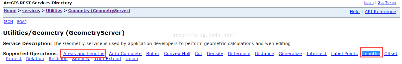
众所周知,使用arcgis api for js实现地图的量算工具功能,无非是调用arcgisserver的Geometry服务(http://localhost:6080/arcgis/rest/services/Utilities/Geometry/GeometryServer)提供的Areas and Lengths以及Lengths,如图:
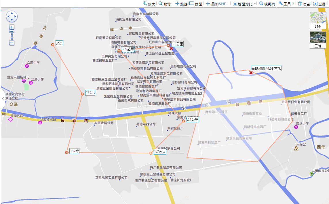
但是我这里提供另一种实现的思路,就是自己写算法来实现距离以及面积的量算,这样的好处是不依赖arcgisserver几何服务,有些项目不排除有些奇特的客户不用Geometry服务的,最终的实现效果图如下:
具体实现思路:创建一个独立的js文件,里面有量算工具类DCIMeature,DCIMeature类构造函数传入地图对象map

construct: function (map) {
    this._dciMap = map;
    this._onClickHandler = dojo.hitch(this, this._onClickHandler);
    this._onMouseMoveHandler = dojo.hitch(this, this._onMouseMoveHandler);
    this._onDrawEndHandler = dojo.hitch(this, this._onDrawEndHandler);
    this._onExtentChangeHandler = dojo.hitch(this, this._onExtentChangeHandler);
    this._onGraphicClearHandler = dojo.hitch(this, this._onGraphicClearHandler);
    this._graphicsLayer = new esri.layers.GraphicsLayer({ id: "DciMeatureGLyr" });
}
核心算法测距:
|
1
2
3
4
5
6
7
8
9
10
11
12
13
14
15
16
17
18
19
20
21
22
23
24
25
26
27
28
29
|
DUtil.getDistanceInEarth =
function
(point1, point2) {
var
d =
new
Number(0);
//1度等于0.0174532925199432957692222222222弧度
//var radPerDegree=0.0174532925199432957692222222222;
var
radPerDegree = Math.PI / 180.0;
if
(DCI.Measure.map.spatialReference.wkid ==
"4326"
) {
var
latLength1 = Math.abs(
this
.translateLonLatToDistance({ x: point1.x, y: point2.y }).x -
this
.translateLonLatToDistance({ x: point2.x, y: point2.y }).x);
var
latLength2 = Math.abs(
this
.translateLonLatToDistance({ x: point1.x, y: point1.y }).x -
this
.translateLonLatToDistance({ x: point2.x, y: point1.y }).x);
var
lonLength = Math.abs(
this
.translateLonLatToDistance({ x: point1.x, y: point2.y }).y -
this
.translateLonLatToDistance({ x: point1.x, y: point1.y }).y);
d = Math.sqrt(Math.pow(lonLength, 2) - Math.pow(Math.abs(latLength1 - latLength2) / 2, 2) + Math.pow(Math.abs(latLength1 - latLength2) / 2 + Math.min(latLength1, latLength2), 2));
}
else
{
var
len_prj = Math.pow((point2.x - point1.x), 2) + Math.pow((point2.y - point1.y), 2);
d = Math.sqrt(len_prj);
}
d = Math.ceil(d);
return
d;
};
DUtil.translateLonLatToDistance =
function
(point) {
var
d =
new
Number(0);
//1度等于0.0174532925199432957692222222222弧度
//var radPerDegree=0.0174532925199432957692222222222;
var
radPerDegree = Math.PI / 180.0;
var
equatorialCircumference = Math.PI * 2 * 6378137;
return
{
x: Math.cos(point.y * radPerDegree) * equatorialCircumference * Math.abs(point.x / 360),
y: equatorialCircumference * Math.abs(point.y / 360)
};
};
|
|
1
|
这里测距的算法有基于地理坐标系以及投影坐标系不同,有不同的计算公式来计算的;
|
测面的核心算法:
//******求三角形面积****
DUtil.getTriangleArea =
function
(point1, point2, point3) {
var
area = 0;
if
(!point1 || !point2 || !point3) {
return
0;
}
if
(DCI.Measure.map.spatialReference.wkid ==
"4326"
) {
point1 =
this
.translateLonLatToDistance(point1);
point2 =
this
.translateLonLatToDistance(point2);
point3 =
this
.translateLonLatToDistance(point3);
}
area = ((point1.x * point2.y - point2.x * point1.y) + (point2.x * point3.y - point3.x * point2.y) + (point3.x * point1.y - point1.x * point3.y)) / 2;
return
area;
};
|
测面算法也是类似,基于地理坐标系以及投影坐标系不同,有不同的计算公式来计算的;
完整的量算工具js文件下载 点击打开链接


 1694
1694


 被折叠的 条评论
为什么被折叠?
被折叠的 条评论
为什么被折叠?
 到【灌水乐园】发言


