室内定位算法,有助于研究者认清研究方向,给定位算法一个准确的描述,是很好的参考教材。the possibility for the user to be notified by visible and Waveformof Distance
audible warnings using buzzer and led
ar to
Very close to al
1903
Tme「 samples
Fig 4 Distance measurement using the RSSi signal
The system is used to determine the distance between
Fig. 2. Tag4M Data Acquisition System
tags and 2, 3, 4 or more APs. The tag scans after the aps
ⅣV. EXPERIMENTS
and sends the rssi values for each ap to the ap which is
associated
The system presented above can be used for objects or In order to read the corresponding rSsi values of all
people localization in an indoor enviro
found access points, a""operation is implemented at
Let's suppose a building where several objects are Tag4M level. The time to scan is smaller than few
distributed all over
milliseconds, because the tag doesnt associate with the all
For a better understanding of the system, it is showed an APs. These values are sent to a pC where the localization
experiment where the objects are placed only at one floor. algorithm is implemented in LabVIFW20 10 (see Fig. 5)
Each of these objects has attached a tag. The devices are
Table I presents a scan operation result. In this case
used to determine the location of the objects in the four APs(which are placed in the floor building)named
building and the distance between tags and APs. To Hawk, Helicopter, Tag4M and WitagServer are detected
measure the distance, the RSSI is processed. This method The corresponding rSSi values(in dBm) measured by the
is not very accurate and is strong depended to the Tag4M are reported for every AP
environment, but is very easy to implement with the
TABLE 1. A SEQUENCE OF RESULTS FOR THE SCANOPERATION
The Fig 3 presents the experiment environment for one EXFCUTED ON THE TAG4M DEVICE
oor where the colored circles represents the APs and the
rectangles represents the objects intended to be located
This floor is divided in six rooms separated by walls
RSSI Scan results: 4
Time Ssid Ch ad-Iloc Sec wps mac Address erp
WMM
SSI Supported Rates(Mbits, Mandatory) Crypto Suites CW
Max/min
AP SCAN. llawk. -57 dBm
AP SCAN, Helicopter, -50 dBm,
AP SCAN, Tag4M.-68 dBm
AP SCAN. WitagServer. -45 dBm
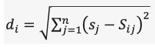
The Rssi values are converted to distance values using
formula(1)
The value of the received signal strength is a function
of the transmitted power and the distance between the
Fig 3. The Experiment Environment
sender and the receiver. The received signal strength will
decrease when the distance increases as the following
First step in finding the location is distance equation shows [23]
measurement using the RSSI signal. The experiment for
computing the distance is presented in Fig. 4. The
RSSI(IOn- logo+A)(1)
experimental precisions of measurements are less than 5
meters
Where:
lal propagation constant al
d
propagation exponent.
d represents the distance from sender,
A represents the received signal strength at a distance of
one meter
worn even by people. The system runs on batterie
w sSID
having a characteristic life time of a couple of years and
回H
offers a platform for sensor measurements. Thus, the
system can use any existent infrastructure, with significant
decrease of implementation costs
REFERENCES
[1] H. Liu, H. Darabi, P. Banerjee and J. Liu, ""Survey of wireless
Distance 2 Tn]
aRch
Indoor Positioning Techniques and SystemS", IEEE
TRANSACTIONS ON SYSTEMS. MAN. AND
CYBERNETICS-PART C: APPLICATIONS AND REVIEWS
VOL 37, NO 6, NOVEMBER 2007, pp. 1067-10801
Distance
3[]
[2
Want, A. Hopper, V. FalcaO, J. Gibbons, "The Active Budge
4MDastDct v
Location System, ACM Transactions on Information Systems
vol. 10, no l, January 1992, pp 91-102.
Fig. 5. Block Diagram of the localization program
[3] Firefly Motion Tracking System User's guide", vcrsion 2.2
December 1999
http://www.gesturecentral.com/firefly/fireflyuserguide.pdf
The application compute the distances between the Wi- [4] Northen Digilal Inc. Website, Oplotrak PROseries, 2011
Fi Tags placed on targets and the APs placed in indoor
http:/www.ndigital.com/industrial/optotrakproseries-family.php
[5] E. Aitenbichler, M. Mhlhuser, An /R Local Positioning System for
environment. For this case, three APs are enough but the
Smart Items and Devices Proc. 23rd IEEE Internationa
number of Aps can be increased for obtaining more
Conference on Distributed Computing Systems Workshops
accurate position estimation. The distances between the
TWSAWC03), 2003
Wi-fiTagsandeachAparerepresentedascirclesasit[6]topaz,2004,http:/www.tadlys.co.il/pAges/productcontent.asp?igi
bald=2
can be seen in Fig. 6, having the centre in the AP locations [7 A. Kotanen, M. Hannikainen, H. Leppakoski, and T. D
which have previously known coordinates. The target's
Hamalaincn, E.cperiments on local positioning with Bluetoothin
position is given by the point at the intersection of the
Proc. IEEE Int Conf. Inf. Technol. Comput. Commun., Apr 2003
three circles
PP.297-303
[8 J. Hallberg, M. Nilsson, and k. Synnes, "Positioning with
Bluetooth"in Proc. Ieee 10th Int Conf. Telecommun. Mar. 2003
ol.2,pp.954958
9
Active bat website. 2008
http:/www.cl.cam.ac.uk/research!dtg/attarchive/bat/
[10] Hazas, M, Hopper, A, "A Novel Brucdbund Ultrasonic Locution
System for Improved Indoor Positioning IEEE Transactions on
mobile Computing. Vol 5, No 5, May 2006
[11 N B Priyantha, The Cricket Indoor Location System", PhD thes
MIT.2005
2]SonitorSystemWebsite2011,http://www.sonitor.com/
[13] Minami M, Fukuju Y, Hirasawa K, Yokoyama S, Mizumachi M
Aoyama T ,"Dolphin. A practical approach for
implementing a fully distributed indoor ultrasonic positioning
system", Ubicomp, 2004, 347-365
Fig. 6. Front Panel of the localization program
14]J. Ilightower, R. Want, and G. borriello, SpotON: An indoor 3D
cation sensing technology hased on RF signal strength"Univ
The simplicity and cost efficiency of the rssi based
Washington, Seattle, Tech Rep UW CSE 2000-02-02, Feb. 2000
localization make the proposed system a desired candidate
15]L. M. Ni, Y. Liu, Y. C. Lau, and A. P. Patil,"LANDMARC: Indoor
location sensing using active RFID Wireless Netw., vol 10, no 6
for specific applications like tracking and positioning
svstems
hP.701-70.N0v.200
Zebra Technologies Corporation
eb sit
http://www.7ebra.com/id/zebra/na/en/index/products/location/isoie
c 24730 2html
V. CONCLUSION
[17 P. Bahl and V. Padmanabhan, "RADAR: An in-building rf based
user location and tracking system, Proc. IEEE INFOCOM, voL 2
In this paper, an indoor localization system based on
March200,pp.775784
ultra-low power Wi-Fi technology and designed to
18Ekahau2011,http://www.ekahau.com:
[19] T. King, S. Kopf, T. Haenselmann, C. Lubberger and w
determine location of objects in a closed environment is
Effelsberg, "COMPASS: A Probabilistic Indoor Positioning System
proposed
gILo
rOC
In the first part of this paper a survey of existing indoor
Workshop on Wireless Network Testbeds, Experimental evaluation
and Cllaracterization (WiNTECID), Los Angeles, CA, USA
positioning systems was made
In the second part was presented the way in which an [20] Convert sensor data to web pages using a Cloud Instrument, june
object can be localized by using access points and Tag 4M
2011.http://www.tag4m.com
devices which may read the rssi values
[21Tag4mDatasheet2010,http://test.tag4m.com/wp-
content/uploads/20/03/Tag4M Prod Datasheet Revised3. pdf
The importance of the proposed system lies in ultra-low [22] Aamodt, K.(2006). CC2431 Location Engine, Application Note
power and Wi-Fi transmission capabilities that are
An042,fromhttp://focus.tii.co.ip/ip/lit/an/swra095/swra095.pdf
embedded in a very small package, why they are suitable
320


 https://mbd.pub/o/bread/ZZ6UmpZw


 1050
1050


 被折叠的 条评论
为什么被折叠?
被折叠的 条评论
为什么被折叠?
 到【灌水乐园】发言


