


转自:http://blog.csdn.net/syy6/article/details/5714631
地理编码(Geocoding)与地理反编码(Reverse Geocoding)是地图操作中的常见操作,前者表示通过街道地址请求空间坐标,后者表示通过空间坐标请求街道地址。通俗的说,二者就是街道地址与经纬度的转换。举例来说,前者就是输入查询"上海市杨浦区四平路1239号"得到(31.285207060526762, 121.50546412914991),而后者则表示这个反过程。
在实际的移动开发过程中,地图相关的操作对于地理编码与地理反编码的使用都是十分普遍。幸运的是,Android的MapView控件中对于这两者都进行了封装,因此可以方便的利用Google Map Service进行二者查询。下面将对开发过程做一个简单介绍。
首先必须进行MapKey的申请,任何地图的显示都需要申请一个MapKey。具体的申请步骤可见
http://code.google.com/intl/zh-CN/android/maps-api-signup.html
然后可以建立一个基于Google APIs的程序,并且在AndroidManifest.xml中加入地图API的支持。
- <?xml version="1.0" encoding="utf-8"?>
- <manifest xmlns:android="http://schemas.android.com/apk/res/android"
- package="net.learn2develop.GoogleMaps"
- android:versionCode="1"
- android:versionName="1.0.0">
- <application android:icon="@drawable/icon" android:label="@string/app_name">
- <uses-library android:name="com.google.android.maps" />
- <activity android:name=".MapsActivity"
- android:label="@string/app_name">
- <intent-filter>
- <action android:name="android.intent.action.MAIN" />
- <category android:name="android.intent.category.LAUNCHER" />
- </intent-filter>
- </activity>
- </application>
- <uses-permission android:name="android.permission.INTERNET" />
- </manifest>
- </xml>
接着可以在主Layout文件中加入对于地图的显示,这里需要加入刚才申请的MapKey,否则地图将无法正常显示。
- <?xml version="1.0" encoding="utf-8"?>
- <RelativeLayout xmlns:android="http://schemas.android.com/apk/res/android"
- android:layout_width="fill_parent"
- android:layout_height="fill_parent">
- <com.google.android.maps.MapView
- android:id="@+id/mapView"
- android:layout_width="fill_parent"
- android:layout_height="fill_parent"
- android:enabled="true"
- android:clickable="true"
- android:apiKey="MapKey"
- />
- </RelativeLayout>
接着在主Activity的JAVA文件进行修改,支持地图显示。
- import com.google.android.maps.MapActivity;
- import com.google.android.maps.MapView;
- import android.os.Bundle;
- public class MapsActivity extends MapActivity
- {
- /** Called when the activity is first created. */
- @Override
- public void onCreate(Bundle savedInstanceState)
- {
- super.onCreate(savedInstanceState);
- setContentView(R.layout.main);
- MapView mapView = (MapView) findViewById(R.id.mapView);
- mapView.setBuiltInZoomControls(true);
- }
- }
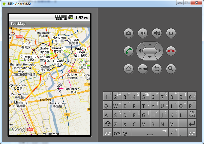
此时运行程序,地图应该就可以正常显示了,见下图。
此时我们再向程序中加入地理编码与地理反编码的功能,其参考代码如下。
地理编码:
- Geocoder geoCoder = new Geocoder(this, Locale.getDefault());
- try {
- List<Address> addresses = geoCoder.getFromLocationName(
- "上海市杨浦区四平路1239号", 5);
- String add = "";
- if (addresses.size() > 0) {
- p = new GeoPoint(
- (int) (addresses.get(0).getLatitude() * 1E6),
- (int) (addresses.get(0).getLongitude() * 1E6));
- mc.animateTo(p);
- mapView.invalidate();
- }
- } catch (IOException e) {
- e.printStackTrace();
- }
地理反编码,其中MapOverlay为地图图层上的叠加图层,用于标识的显示以及点击事件的捕捉。
- class MapOverlay extends com.google.android.maps.Overlay
- {
- @Override
- public boolean draw(Canvas canvas, MapView mapView,
- boolean shadow, long when)
- {
- //...
- }
- @Override
- public boolean onTouchEvent(MotionEvent event, MapView mapView)
- {
- //---when user lifts his finger---
- if (event.getAction() == 1) {
- GeoPoint p = mapView.getProjection().fromPixels(
- (int) event.getX(),
- (int) event.getY());
- Geocoder geoCoder = new Geocoder(
- getBaseContext(), Locale.getDefault());
- try {
- List<Address> addresses = geoCoder.getFromLocation(
- p.getLatitudeE6() / 1E6,
- p.getLongitudeE6() / 1E6, 1);
- String add = "";
- if (addresses.size() > 0)
- {
- for (int i=0; i<addresses.get(0).getMaxAddressLineIndex();
- i++)
- add += addresses.get(0).getAddressLine(i) + "/n";
- }
- Toast.makeText(getBaseContext(), add, Toast.LENGTH_SHORT).show();
- }
- catch (IOException e) {
- e.printStackTrace();
- }
- return true;
- }
- else
- return false;
- }
- }
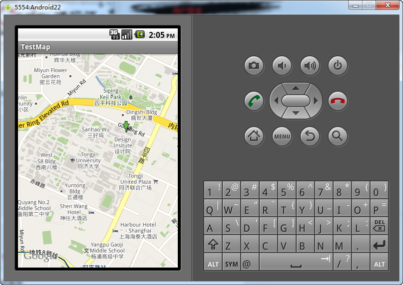
最终实现结果如下图所示,地理编码,查询“上海市杨浦区四平路1239号”,结果其实略有偏差。中国的地址与邮编比较混乱,所以结果有些地方无法做到完全准确。
地理反编码


 680
680


 被折叠的 条评论
为什么被折叠?
被折叠的 条评论
为什么被折叠?
 到【灌水乐园】发言


