


叠加Shp数据。
注意事项
Shp数据在Skyline Web中显示的时候有部分属性是缺失的,需要编码调整后才能正常显示,且需要注意是叠加在底图上,需要把三维模型取消掉才能看得到,否则会被压盖住。
因为需要在Shp数据的面上做点击弹出事件,如果一个Shp数据含多个点或面等,需要使用到GeoTools开源工具包在内部解析多个中心坐标点位,因为Skyline中自带只能解析一个中心点位,被打脸...,在Skyline中也带有可以获取多个点或面的方法,详见API。
这个案例中的Shp数据从本地加载,可以改成网络发布。
需求分解
- 构建特征数据
- 构建信息显示窗口
方法说明
- SGWorld66.Creator.CreateFeatureLayer(layerName,sConnectionString,GroupID);
- 创建特征层,layerName为名称,sConnectionString为数据源,GroupID为目录树组。sConnectionString为数据源的组织方式,可以加载多种数据,详见API。
- 需要注意的是:创建完该对象后,需要配置IgnoreZ=false;属性和Refresh();方法,才能正常显示。
- SGWorld66.Creator.CreateMessage(TargetPosition,msgData,Type,BringToFront);
- 创建信息对象,后通过属性关联。我们这里采用了信息的第五个类型,简单的POPUP对象,如需要完整的POPUP对象(可设置Caption),需要创建CreatePopupMessage对象来完成。
Jsp源码
<%@ page language="java" import="java.util.*" pageEncoding="UTF-8"%>
<%@ include file="/WEB-INF/views/include/taglib.jsp"%>
<%
String path = request.getContextPath();
String basePath = request.getScheme()+"://"+request.getServerName()+":"+request.getServerPort()+path+"/";
%>

<%@ page import="com.thinkgem.jeesite.common.utils.SpringContextHolder"%>
<%@ page import="com.thinkgem.jeesite.common.test.ShpTest"%>
<%@ page import="com.vividsolutions.jts.geom.Point"%>

<%
ShpTest shpTest = SpringContextHolder.getBean(ShpTest.class);
List<Point> pointList = shpTest.readSHP("F:\\ShpTest3\\wj.shp");
%>

<html>
	<script type="text/javascript" >
	 /**
	  * 初始化
	  */
	 function Init() {
		try {
			//文件地址
	        var flyPath = "F:\\YFSY0519\\YFSY0519.fly";
	        //打开工程
	        SGWorld66.Project.Open(flyPath);

	        var shpLayer = SGWorld66.Creator.CreateFeatureLayer("基底图地形","FileName=F:\\ShpTest2\\基底图地形.shp;TEPlugName=OGR;");
	        shpLayer.IgnoreZ = false;
	        shpLayer.Refresh();

	        var labelStyle = createLabelStyle(0xFF0000,0,"微软雅黑",20,200,true);

	        var shpLayer1 = SGWorld66.Creator.CreateFeatureLayer("违章建筑1-SHP","FileName=F:\\ShpTest3\\wj.shp;TEPlugName=OGR;");
	        shpLayer1.IgnoreZ = false;
	        shpLayer1.Refresh();
	        shpLayer1.FeatureGroups.SetProperty("Fill Opacity","100%");
	        shpLayer1.FeatureGroups.SetProperty("Fill Color","#00ff00");
	        <% for(int i=0;i<pointList.size();i++){
	        	Point p = pointList.get(i);
	        %>
	        var p<%=i%> = SGWorld66.Creator.CreatePosition(<%=p.getX()%>,<%=p.getY()%>,0,0,0,0);
	        var ctl<%=i%> = SGWorld66.Creator.CreateTextLabel(p<%=i%>, "违章建筑" + <%=i%>, labelStyle, "", "违章建筑" + <%=i%>);
	        ctl<%=i%>.Message.MessageID = SGWorld66.Creator.CreateMessage(5,"建筑时间:20170666",0).ID;
	        <% } %>

	        var shpLayer2 = SGWorld66.Creator.CreateFeatureLayer("违章建筑-SHP","FileName=F:\\ShpTest3\\wj2.shp;TEPlugName=OGR;");
	        shpLayer2.IgnoreZ = false;
	        shpLayer2.Refresh();
	        shpLayer2.FeatureGroups.SetProperty("Fill Opacity","100%");
	        shpLayer2.FeatureGroups.SetProperty("Fill Color","#6f11ee");
	        var ctl2 = SGWorld66.Creator.CreateTextLabel(shpLayer2.Position, "违章建筑", labelStyle, "", "违章建筑");
	        ctl2.Message.MessageID = SGWorld66.Creator.CreateMessage(5,"建筑时间:20170612",0).ID;

	    } catch (e) {
	        alert("Error: " + e.description);
	    }
	}

	 /**
		 *设置文本标注样式
		 */
		function createLabelStyle(nBGRValue,dAlpha,FontName,FontSize,Scale,Bold){
			// C1. Create label syle
			var cLabelStyle = SGWorld66.Creator.CreateLabelStyle();
			// C2. Change label style settings
			var nBGRValue = nBGRValue;  // Blue
			var dAlpha = dAlpha;        // 50% opacity
			var cBackgroundColor = cLabelStyle.BackgroundColor;     // Get label style background color
			cBackgroundColor.FromBGRColor(nBGRValue);               // Set background to blue
			cBackgroundColor.SetAlpha(dAlpha);                      // Set transparency to 50%
			cLabelStyle.BackgroundColor = cBackgroundColor;         // Set label style background color
			cLabelStyle.FontName = FontName;                      // Set font name
			cLabelStyle.FontSize = FontSize;                              // Set font size
			cLabelStyle.Italic = false;                             // Set label style font to italic
			cLabelStyle.Scale = Scale;                                 // Set label style scale
			cLabelStyle.Bold = Bold;
			//cLabelStyle.MaxViewingHeight = MaxViewingHeight;
			cLabelStyle.LimitScreenSize = true;
			cLabelStyle.LineToGround = true;
			//cLabelStyle.MinViewingHeight = MinViewingHeight;
			return cLabelStyle;
		}

	function Even(){

	}

	</script>
	<style>
  		.btn{
	  		border: none;
			display: inline-block;
			outline: 0;
			padding: 6px 16px;
			margin-bottom: 10px;
			vertical-align: middle;
			overflow: hidden;
			text-decoration: none;
			color: #fff;
			background-color: #3385ff;
			text-align: center;
			transition: .2s ease-out;
			cursor: pointer;
			white-space: nowrap;
			width: 100%;
			margin-top: 5px;
  		}
	</style>

	<body onload = "Init();" style="background-color: black;padding:0; margin:0;overflow: hidden;">
		<div style="position: absolute;width: 80%;height: 100%;left: 0%;">
			<!--定义一个TerraExplorer 3D窗口对象-->
			<object id="TE" classid="clsid:3a4f9192-65a8-11d5-85c1-0001023952c1" style="width: 100%;height: 100%;padding:0; margin:0;"></object>
		</div>
		<div style=" position: absolute;width: 18%;height: 99%;left: 81%;">
			<!--定义一个TerraExplorer 信息窗口对象-->
			<object id="TEInformationWindow" classid="CLSID:3a4f9193-65a8-11d5-85c1-0001023952c1" style="width: 100%;height: 50%;"></object>
			<!--定义TerraExplorer对象SGWorld66-->
			<object id="SGWorld66" classid="CLSID:3a4f9199-65a8-11d5-85c1-0001023952c1" style="visibility:hidden;height:0;"></object>
			<div>
				<input id="Button1" value="示例按钮-编辑事件" onclick="Even()" type="button" class="btn"/>
			</div>
		</div>
	</body>
</html>
Java源码
package com.thinkgem.jeesite.common.test;

import java.io.File;
import java.io.IOException;
import java.io.Serializable;
import java.net.MalformedURLException;
import java.nio.charset.Charset;
import java.util.ArrayList;
import java.util.Collection;
import java.util.HashMap;
import java.util.Iterator;
import java.util.List;
import java.util.Map;

import org.geotools.data.DataUtilities;
import org.geotools.data.DefaultTransaction;
import org.geotools.data.FeatureSource;
import org.geotools.data.Transaction;
import org.geotools.data.shapefile.ShapefileDataStore;
import org.geotools.data.shapefile.ShapefileDataStoreFactory;
import org.geotools.data.simple.SimpleFeatureCollection;
import org.geotools.data.simple.SimpleFeatureSource;
import org.geotools.data.simple.SimpleFeatureStore;
import org.geotools.feature.FeatureCollection;
import org.geotools.feature.FeatureCollections;
import org.geotools.feature.FeatureIterator;
import org.geotools.feature.simple.SimpleFeatureBuilder;
import org.geotools.referencing.crs.DefaultGeographicCRS;
import org.opengis.feature.Property;
import org.opengis.feature.simple.SimpleFeature;
import org.opengis.feature.simple.SimpleFeatureType;
import org.springframework.stereotype.Service;
import org.springframework.transaction.annotation.Transactional;

import com.vividsolutions.jts.geom.Coordinate;
import com.vividsolutions.jts.geom.GeometryFactory;
import com.vividsolutions.jts.geom.MultiPolygon;
import com.vividsolutions.jts.geom.Point;

@Service
@Transactional(readOnly = true)
public class ShpTest {

	public static List<Point> readSHP(String path) {
	    ShapefileDataStore shpDataStore = null;
	    List<Point> pointList = new ArrayList<Point>();
	    try{
	        shpDataStore = new ShapefileDataStore(new File(path).toURI().toURL());
	        shpDataStore.setStringCharset(Charset.forName("GBK"));
	        String typeName = shpDataStore.getTypeNames()[0];
	        FeatureSource<SimpleFeatureType, SimpleFeature> featureSource = null;
	        featureSource = (FeatureSource<SimpleFeatureType, SimpleFeature>)shpDataStore.getFeatureSource(typeName);
	        FeatureCollection<SimpleFeatureType, SimpleFeature> result = featureSource.getFeatures();
	        System.out.println(result.size());
	        FeatureIterator<SimpleFeature> itertor = result.features();
	        while(itertor.hasNext()){
	            SimpleFeature feature = itertor.next();
	            Collection<Property> p = feature.getProperties();
	            Iterator<Property> it = p.iterator();
	            while(it.hasNext()) {
	                Property pro = it.next();
	                if (pro.getValue() instanceof Point) {
	                    System.out.println("PointX = " + ((Point)(pro.getValue())).getX());
	                    System.out.println("PointY = " + ((Point)(pro.getValue())).getY());
	                } if(pro.getValue() instanceof MultiPolygon){
	                	MultiPolygon mp = (MultiPolygon)(pro.getValue());
	                	System.out.println(mp.getCentroid());
	                	pointList.add(mp.getCentroid());
	                } else {
	                    System.out.println(pro.getName() + " = " + pro.getValue());
	                }
	            }
	        }
	        itertor.close();
	    } catch (MalformedURLException e) {
	        e.printStackTrace();
	    } catch(IOException e) { e.printStackTrace(); }
	    return pointList;
	}
}
Maven
GeoTools采用的2.7.2版本。
<repository>
<id>geotools-repos</id>
<name>GeoTools Repository</name>
<url>http://download.osgeo.org/webdav/geotools/</url>
</repository>
<repository>
<id>geotools2-repos</id>
<name>GeoTools2 Repository</name>
<url>http://repo1.maven.org/maven2/</url>
</repository>
<!-- GEOTOOLS begin -->
<!-- https://mvnrepository.com/artifact/org.geotools/gt-api -->
<dependency>
<groupId>org.geotools</groupId>
<artifactId>gt-api</artifactId>
<version>2.7.2</version>
</dependency>
<!-- https://mvnrepository.com/artifact/org.geotools/gt-data -->
<dependency>
<groupId>org.geotools</groupId>
<artifactId>gt-data</artifactId>
<version>2.7.2</version>
</dependency>
<dependency>
<groupId>org.geotools</groupId>
<artifactId>gt-main</artifactId>
<version>2.7.2</version>
</dependency>
<dependency>
<groupId>org.geotools</groupId>
<artifactId>gt-metadata</artifactId>
<version>2.7.2</version>
</dependency>
<dependency>
<groupId>org.geotools</groupId>
<artifactId>gt-opengis</artifactId>
<version>2.7.2</version>
</dependency>
<dependency>
<groupId>org.geotools</groupId>
<artifactId>gt-shapefile</artifactId>
<version>2.7.2</version>
</dependency>
<!-- https://mvnrepository.com/artifact/javax.measure/jsr-275 -->
<dependency>
<groupId>javax.measure</groupId>
<artifactId>jsr-275</artifactId>
<version>1.0.0</version>
</dependency>
<!-- https://mvnrepository.com/artifact/com.vividsolutions/jts -->
<dependency>
<groupId>com.vividsolutions</groupId>
<artifactId>jts</artifactId>
<version>1.11</version>
</dependency>
<dependency>
<groupId>org.geotools</groupId>
<artifactId>gt-referencing</artifactId>
<version>2.7.2</version>
<scope>system</scope>
<systemPath>${project.basedir}/src/main/webapp/WEB-INF/lib/gt-referencing-2.7.2.jar</systemPath>
</dependency>
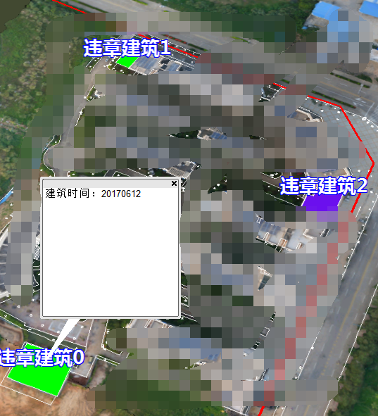
<!-- GEOTOOLS end -->效果图


 852
852


 被折叠的 条评论
为什么被折叠?
被折叠的 条评论
为什么被折叠?
 到【灌水乐园】发言


