PIE SDK与GeoServer结合说明文档

 1.  GeoServer简介

    GeoServer是OpenGIS Web服务器规范的J2EE实现的社区开源项目,利用GeoServer可以方便的发布地图数据,允许用户对特征数据进行更新、删除、插入操作,通过GeoServer可以容易的在用户之间迅速共享空间地理信息。它能兼容WMS和 WFS 特性;支持 PostGIS、Shapefile、ArcSDE、Oracle、VPF、MySQL、MapInfo;支持上百种投影;能够将网络地图输出为 jpeg、gif、png、SVG、KML等格式;支持AJAX 的地图客户端OpenLayers。


   GeoServer的安装参考:https://blog.csdn.net/qq_35732147/article/details/81869864

   GeoServer发布WMTS服务参考:

   https://blog.csdn.net/weixin_38843590/article/details/79879317


2.  应用介绍说明

  2.1.  应用场景介绍

    应用项目中经常遇到WebGIS和桌面GIS中共享一份地图或多个桌面端共享一份地图,应对这个问题的最优的方案就是把数据发布成一份地图服务,通过WMTS地图服务实现不同终端的数据共享。下面我们介绍如何在PIE中加载GeoServer发布的地图服务。

  2.2.  实现思路介绍

    要在PIE中加载GeoServer地图服务,可以通过PIE的自定义瓦片服务接口ICustomerOnlineTiledLayer来完成。要实现它我们需要知道瓦片的地址,那么如何找到GeoServer中WMTS服务的瓦片地址呢?下面演示如何在google浏览器下获得瓦片的路径:


粘贴得到:http://localhost:8080/geoserver/gwc/service/wmts?layer=PIEServer%3AWorldBaseMap&style=&tilematrixset=EPSG%3A4326&Service=WMTS&Request=GetTile&Version=1.0.0&Format=image%2Fpng&TileMatrix=EPSG%3A4326%3A7&TileCol=201&TileRow=44

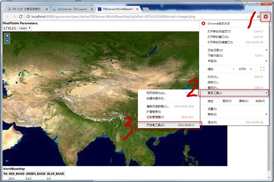
标红的7代表切片的级别,标红的201代表切片的列编号,标红的44代表切片的行编号,修改为对应的标识符为:

http://localhost:8080/geoserver/gwc/service/wmts?layer=PIEServer%3AWorldBaseMap&style=&tilematrixset=EPSG%3A4326&Service=WMTS&Request=GetTile&Version=1.0.0&Format=image%2Fpng&TileMatrix=EPSG%3A4326%3A[$Level]&TileCol=[$Column]&TileRow=[$Row]

 2.3. 核心接口和方法

接口/类

方法

说明

ICustomerOnlineTiledLayer

SetTileInfo(TileInfo info);

设置瓦片信息

TileInfo

DPI

切片DPI,一般为96;

SpatialReference

地图服务坐标系;

Origin

地图服务切片起始点;

InitialExtent

地图服务的数据范围;

FullExtent

地图服务的全局范围

Format

切片的格式,一般为Png;

TileWidth

切片宽度,一般为256;

TileHeight

切片高度,一般为256;

LODInfos

切片级别信息;

LODInfo

Level

切片级别编号;(从0开始)

Resolution

该级别分辨率;

Scale

该级别比例尺;


2.4. 示例代码

项目路径

百度云盘地址下/PIE示例程序/14.SDK拓展开发/04PIE SDK与GeoServer结合/PIEMapApplication_GeoServer

数据路径

百度云盘地址下/PIE示例数据/栅格数据/04.World/World.tif

视频路径

百度云盘地址下/PIE视频教程/14.SDK拓展开发/ PIE SDK与GeoServer结合.avi

示例代码

 1 /// <summary>
 2 /// 增加用户自定义切片服务图层
 3 /// </summary>
 4 public void AddCustomTiledLayer()
 5 {
 6 // 创建自定义瓦片地图服务图层
 7       string url = "http://localhost:8080/geoserver/gwc/service/wmts?layer=PIEServer%3A
 8 WorldBaseMap&style=&tilematrixset=EPSG%3A4326&Service=WMTS&Request=GetTil
 9 e&Version=1.0.0&Format=image%2Fpng&TileMatrix=EPSG%3A4326%3A[$Level]&TileC
10 ol=[$Column]&TileRow=[$Row]";
11       CustomerOnlineTiledLayer layer = new CustomerOnlineTiledLayer(url);
12       layer.Name = "World";
13 
14       // 设置自定义瓦片地图服务图层的地图切片信息
15       PIE.Carto.TileInfo tileInfo = new TileInfo();
16       tileInfo.Format = (PIE.Carto.TileImageFormat)1;
17       tileInfo.DPI = 96;
18       tileInfo.TileWidth = 256;
19       tileInfo.TileHeight = 256;
20       tileInfo.CompressionQuality = 75;
21       tileInfo.LODInfos = new List<LODInfo>();
22       double dResolution = 0.703125;
23       double dScale = 2.95497598570834E8;
24       for (int i = 0; i < 16; ++i)
25       {
26            PIE.Carto.LODInfo lodInfo = new LODInfo();
27            lodInfo.Level = i;
28            lodInfo.Resolution = dResolution / Math.Pow(2.0, i);
29            lodInfo.Scale = dScale / Math.Pow(2.0, i); ;
30            tileInfo.LODInfos.Add(lodInfo);
31       }
32       ISpatialReference spatialReference = SpatialReferenceFactory.CreateSpatialReference(4326);
33       tileInfo.SpatialReference = spatialReference;
34 
35       // 设置自定义瓦片地图服务图层的起始点和范围信息
36       IPoint point = new PIE.Geometry.Point();
37       point.PutCoords(-180, 90);
38       (point as IGeometry).SpatialReference = spatialReference;
39       tileInfo.Origin = point;
40       IEnvelope envelope = new Envelope();
41       envelope.PutCoords(-180, -90, 180, 90);
42       tileInfo.InitialExtent = envelope;
43       tileInfo.FullExtent = envelope;
44       layer.SetTileInfo(tileInfo);
45 
46       // 加载到地图并刷新
47       m_HookHelper.FocusMap.AddLayer(layer);
48       m_HookHelper.ActiveView.PartialRefresh(ViewDrawPhaseType.ViewAll);
49 }

2.5.  示例截图

转载于:https://www.cnblogs.com/PIESat/p/10337992.html

  • 0
    点赞
  • 0
    收藏
    觉得还不错? 一键收藏
  • 0
    评论
1 Introduction 3 1.1 Overview . . . . . . . . . . . . . . . . . . . . . . . . . . . . . . . . . . . . . . . . . . . . . . . . 3 1.2 History . . . . . . . . . . . . . . . . . . . . . . . . . . . . . . . . . . . . . . . . . . . . . . . . . . 3 1.3 Getting involved . . . . . . . . . . . . . . . . . . . . . . . . . . . . . . . . . . . . . . . . . . . . 4 1.4 License . . . . . . . . . . . . . . . . . . . . . . . . . . . . . . . . . . . . . . . . . . . . . . . . . . 6 2 Installation 7 2.1 Windows installer . . . . . . . . . . . . . . . . . . . . . . . . . . . . . . . . . . . . . . . . . . . 7 2.2 Windows binary . . . . . . . . . . . . . . . . . . . . . . . . . . . . . . . . . . . . . . . . . . . . 14 2.3 Mac OS X installer . . . . . . . . . . . . . . . . . . . . . . . . . . . . . . . . . . . . . . . . . . . 15 2.4 Mac OS X binary . . . . . . . . . . . . . . . . . . . . . . . . . . . . . . . . . . . . . . . . . . . . 16 2.5 Linux binary . . . . . . . . . . . . . . . . . . . . . . . . . . . . . . . . . . . . . . . . . . . . . . 18 2.6 Web archive . . . . . . . . . . . . . . . . . . . . . . . . . . . . . . . . . . . . . . . . . . . . . . . 19 2.7 Upgrading existing versions . . . . . . . . . . . . . . . . . . . . . . . . . . . . . . . . . . . . . 20 3 Getting Started 23 3.1 Web Administration Interface Quickstart . . . . . . . . . . . . . . . . . . . . . . . . . . . . . . 23 3.2 Publishing a Shapefile . . . . . . . . . . . . . . . . . . . . . . . . . . . . . . . . . . . . . . . . . 29 3.3 Publishing a PostGIS Table . . . . . . . . . . . . . . . . . . . . . . . . . . . . . . . . . . . . . . 36 4 GeoServer Data Directory 43 4.1 Creating a New Data Directory . . . . . . . . . . . . . . . . . . . . . . . . . . . . . . . . . . . . 43 4.2 Setting the Data Directory . . . . . . . . . . . . . . . . . . . . . . . . . . . . . . . . . . . . . . . 44 4.3 Structure of the Data Directory . . . . . . . . . . . . . . . . . . . . . . . . . . . . . . . . . . . . 46 4.4 Migrating a Data Directory between different versions . . . . . . . . . . . . . . . . . . . . . . 49 5 Web Administration Interface 53 5.1 Interface basics . . . . . . . . . . . . . . . . . . . . . . . . . . . . . . . . . . . . . . . . . . . . . 53 5.2 Server . . . . . . . . . . . . . . . . . . . . . . . . . . . . . . . . . . . . . . . . . . . . . . . . . . 55 5.3 Layer Preview . . . . . . . . . . . . . . . . . . . . . . . . . . . . . . . . . . . . . . . . . . . . . 67 5.4 Data . . . . . . . . . . . . . . . . . . . . . . . . . . . . . . . . . . . . . . . . . . . . . . . . . . . 70 5.5 Services . . . . . . . . . . . . . . . . . . . . . . . . . . . . . . . . . . . . . . . . . . . . . . . . . 96 5.6 Tile Caching . . . . . . . . . . . . . . . . . . . . . . . . . . . . . . . . . . . . . . . . . . . . . . . 106 5.7 Security . . . . . . . . . . . . . . . . . . . . . . . . . . . . . . . . . . . . . . . . . . . . . . . . . 124 5.8 Demos . . . . . . . . . . . . . . . . . . . . . . . . . . . . . . . . . . . . . . . . . . . . . . . . . . 150 6 Working with Vector Data 155 6.1 Shapefile . . . . . . . . . . . . . . . . . . . . . . . . . . . . . . . . . . . . . . . . . . . . . . . . . 155 6.2 Directory of spatial files . . . . . . . . . . . . . . . . . . . . . . . . . . . . . . . . . . . . . . . . 157 i 6.3 Java Properties . . . . . . . . . . . . . . . . . . . . . . . . . . . . . . . . . . . . . . . . . . . . . 159 6.4 GML . . . . . . . . . . . . . . . . . . . . . . . . . . . . . . . . . . . . . . . . . . . . . . . . . . . 161 6.5 VPF . . . . . . . . . . . . . . . . . . . . . . . . . . . . . . . . . . . . . . . . . . . . . . . . . . . . 161 6.6 Pregeneralized Features . . . . . . . . . . . . . . . . . . . . . . . . . . . . . . . . . . . . . . . . 163 7 Working with Raster Data 165 7.1 GeoTIFF . . . . . . . . . . . . . . . . . . . . . . . . . . . . . . . . . . . . . . . . . . . . . . . . . 165 7.2 GTOPO30 . . . . . . . . . . . . . . . . . . . . . . . . . . . . . . . . . . . . . . . . . . . . . . . . 166 7.3 WorldImage . . . . . . . . . . . . . . . . . . . . . . . . . . . . . . . . . . . . . . . . . . . . . . . 167 7.4 ImageMosaic . . . . . . . . . . . . . . . . . . . . . . . . . . . . . . . . . . . . . . . . . . . . . . 168 7.5 ArcGrid . . . . . . . . . . . . . . . . . . . . . . . . . . . . . . . . . . . . . . . . . . . . . . . . . 169 7.6 GDAL Image Formats . . . . . . . . . . . . . . . . . . . . . . . . . . . . . . . . . . . . . . . . . 171 7.7 Oracle Georaster . . . . . . . . . . . . . . . . . . . . . . . . . . . . . . . . . . . . . . . . . . . . 177 7.8 Postgis Raster . . . . . . . . . . . . . . . . . . . . . . . . . . . . . . . . . . . . . . . . . . . . . . 180 7.9 ImagePyramid . . . . . . . . . . . . . . . . . . . . . . . . . . . . . . . . . . . . . . . . . . . . . 180 7.10 Image Mosaic JDBC . . . . . . . . . . . . . . . . . . . . . . . . . . . . . . . . . . . . . . . . . . 182 7.11 Custom JDBC Access for image data . . . . . . . . . . . . . . . . . . . . . . . . . . . . . . . . . 182 7.12 Coverage Views . . . . . . . . . . . . . . . . . . . . . . . . . . . . . . . . . . . . . . . . . . . . 183 8 Working with Databases 187 8.1 PostGIS . . . . . . . . . . . . . . . . . . . . . . . . . . . . . . . . . . . . . . . . . . . . . . . . . 187 8.2 H2 . . . . . . . . . . . . . . . . . . . . . . . . . . . . . . . . . . . . . . . . . . . . . . . . . . . . 192 8.3 ArcSDE . . . . . . . . . . . . . . . . . . . . . . . . . . . . . . . . . . . . . . . . . . . . . . . . . 194 8.4 DB2 . . . . . . . . . . . . . . . . . . . . . . . . . . . . . . . . . . . . . . . . . . . . . . . . . . . . 200 8.5 MySQL . . . . . . . . . . . . . . . . . . . . . . . . . . . . . . . . . . . . . . . . . . . . . . . . . 201 8.6 Oracle . . . . . . . . . . . . . . . . . . . . . . . . . . . . . . . . . . . . . . . . . . . . . . . . . . 204 8.7 Microsoft SQL Server and SQL Azure . . . . . . . . . . . . . . . . . . . . . . . . . . . . . . . . 208 8.8 Teradata . . . . . . . . . . . . . . . . . . . . . . . . . . . . . . . . . . . . . . . . . . . . . . . . . 210 8.9 Database Connection Pooling . . . . . . . . . . . . . . . . . . . . . . . . . . . . . . . . . . . . . 218 8.10 JNDI . . . . . . . . . . . . . . . . . . . . . . . . . . . . . . . . . . . . . . . . . . . . . . . . . . . 219 8.11 SQL Views . . . . . . . . . . . . . . . . . . . . . . . . . . . . . . . . . . . . . . . . . . . . . . . . 220 8.12 Controlling feature ID generation in spatial databases . . . . . . . . . . . . . . . . . . . . . . 224 8.13 Custom SQL session start/stop scripts . . . . . . . . . . . . . . . . . . . . . . . . . . . . . . . 226 8.14 Using SQL session scripts to control authorizations at the database level . . . . . . . . . . . . 226 9 Working with Application Schemas 229 9.1 Complex Features . . . . . . . . . . . . . . . . . . . . . . . . . . . . . . . . . . . . . . . . . . . 229 9.2 Installation . . . . . . . . . . . . . . . . . . . . . . . . . . . . . . . . . . . . . . . . . . . . . . . 233 9.3 WFS Service Settings . . . . . . . . . . . . . . . . . . . . . . . . . . . . . . . . . . . . . . . . . . 233 9.4 Configuration . . . . . . . . . . . . . . . . . . . . . . . . . . . . . . . . . . . . . . . . . . . . . . 234 9.5 Mapping File . . . . . . . . . . . . . . . . . . . . . . . . . . . . . . . . . . . . . . . . . . . . . . 235 9.6 Application Schema Resolution . . . . . . . . . . . . . . . . . . . . . . . . . . . . . . . . . . . 243 9.7 Supported GML Versions . . . . . . . . . . . . . . . . . . . . . . . . . . . . . . . . . . . . . . . 245 9.8 Secondary Namespaces . . . . . . . . . . . . . . . . . . . . . . . . . . . . . . . . . . . . . . . . 246 9.9 CQL functions . . . . . . . . . . . . . . . . . . . . . . . . . . . . . . . . . . . . . . . . . . . . . 248 9.10 Property Interpolation . . . . . . . . . . . . . . . . . . . . . . . . . . . . . . . . . . . . . . . . . 252 9.11 Data Stores . . . . . . . . . . . . . . . . . . . . . . . . . . . . . . . . . . . . . . . . . . . . . . . 253 9.12 Feature Chaining . . . . . . . . . . . . . . . . . . . . . . . . . . . . . . . . . . . . . . . . . . . . 259 9.13 Polymorphism . . . . . . . . . . . . . . . . . . . . . . . . . . . . . . . . . . . . . . . . . . . . . 266 9.14 Data Access Integration . . . . . . . . . . . . . . . . . . . . . . . . . . . . . . . . . . . . . . . . 272 9.15 WMS Support . . . . . . . . . . . . . . . . . . . . . . . . . . . . . . . . . . . . . . . . . . . . . . 274 9.16 WFS 2.0 Support . . . . . . . . . . . . . . . . . . . . . . . . . . . . . . . . . . . . . . . . . . . . 278 9.17 Joining Support For Performance . . . . . . . . . . . . . . . . . . . . . . . . . . . . . . . . . . 279 9.18 Tutorial . . . . . . . . . . . . . . . . . . . . . . . . . . . . . . . . . . . . . . . . . . . . . . . . . 280 ii 10 Working with Cascaded Services 289 10.1 External Web Feature Server . . . . . . . . . . . . . . . . . . . . . . . . . . . . . . . . . . . . . 289 10.2 Cascaded Web Feature Service Stored Queries . . . . . . . . . . . . . . . . . . . . . . . . . . . 291 10.3 External Web Map Server . . . . . . . . . . . . . . . . . . . . . . . . . . . . . . . . . . . . . . . 293 11 Filtering in GeoServer 297 11.1 Supported filter languages . . . . . . . . . . . . . . . . . . . . . . . . . . . . . . . . . . . . . . 297 11.2 Filter Encoding Reference . . . . . . . . . . . . . . . . . . . . . . . . . . . . . . . . . . . . . . . 298 11.3 ECQL Reference . . . . . . . . . . . . . . . . . . . . . . . . . . . . . . . . . . . . . . . . . . . . 303 11.4 Filter functions . . . . . . . . . . . . . . . . . . . . . . . . . . . . . . . . . . . . . . . . . . . . . 306 11.5 Filter Function Reference . . . . . . . . . . . . . . . . . . . . . . . . . . . . . . . . . . . . . . . 308 12 Styling 317 12.1 Introduction to SLD . . . . . . . . . . . . . . . . . . . . . . . . . . . . . . . . . . . . . . . . . . 317 12.2 Working with SLD . . . . . . . . . . . . . . . . . . . . . . . . . . . . . . . . . . . . . . . . . . . 319 12.3 SLD Cookbook . . . . . . . . . . . . . . . . . . . . . . . . . . . . . . . . . . . . . . . . . . . . . 321 12.4 SLD Reference . . . . . . . . . . . . . . . . . . . . . . . . . . . . . . . . . . . . . . . . . . . . . 378 12.5 SLD Extensions in GeoServer . . . . . . . . . . . . . . . . . . . . . . . . . . . . . . . . . . . . . 419 12.6 SLD Tips and Tricks . . . . . . . . . . . . . . . . . . . . . . . . . . . . . . . . . . . . . . . . . . 463 13 Services 473 13.1 Web Feature Service . . . . . . . . . . . . . . . . . . . . . . . . . . . . . . . . . . . . . . . . . . 473 13.2 Web Map Service . . . . . . . . . . . . . . . . . . . . . . . . . . . . . . . . . . . . . . . . . . . . 489 13.3 Web Coverage Service . . . . . . . . . . . . . . . . . . . . . . . . . . . . . . . . . . . . . . . . . 517 13.4 Virtual OWS Services . . . . . . . . . . . . . . . . . . . . . . . . . . . . . . . . . . . . . . . . . 520 14 REST configuration 525 14.1 REST configuration API reference . . . . . . . . . . . . . . . . . . . . . . . . . . . . . . . . . . 525 14.2 REST configuration examples . . . . . . . . . . . . . . . . . . . . . . . . . . . . . . . . . . . . . 551 15 Advanced GeoServer Configuration 575 15.1 Coordinate Reference System Handling . . . . . . . . . . . . . . . . . . . . . . . . . . . . . . . 575 15.2 Advanced log configuration . . . . . . . . . . . . . . . . . . . . . . . . . . . . . . . . . . . . . 585 15.3 WMS Decorations . . . . . . . . . . . . . . . . . . . . . . . . . . . . . . . . . . . . . . . . . . . 586 16 Security 589 16.1 Role system . . . . . . . . . . . . . . . . . . . . . . . . . . . . . . . . . . . . . . . . . . . . . . . 589 16.2 Authentication . . . . . . . . . . . . . . . . . . . . . . . . . . . . . . . . . . . . . . . . . . . . . 598 16.3 Passwords . . . . . . . . . . . . . . . . . . . . . . . . . . . . . . . . . . . . . . . . . . . . . . . . 608 16.4 Root account . . . . . . . . . . . . . . . . . . . . . . . . . . . . . . . . . . . . . . . . . . . . . . 611 16.5 Service Security . . . . . . . . . . . . . . . . . . . . . . . . . . . . . . . . . . . . . . . . . . . . . 611 16.6 Layer security . . . . . . . . . . . . . . . . . . . . . . . . . . . . . . . . . . . . . . . . . . . . . . 614 16.7 REST Security . . . . . . . . . . . . . . . . . . . . . . . . . . . . . . . . . . . . . . . . . . . . . . 617 16.8 Disabling security . . . . . . . . . . . . . . . . . . . . . . . . . . . . . . . . . . . . . . . . . . . 619 16.9 Tutorials . . . . . . . . . . . . . . . . . . . . . . . . . . . . . . . . . . . . . . . . . . . . . . . . . 619 17 Running in a Production Environment 659 17.1 Java Considerations . . . . . . . . . . . . . . . . . . . . . . . . . . . . . . . . . . . . . . . . . . 659 17.2 Container Considerations . . . . . . . . . . . . . . . . . . . . . . . . . . . . . . . . . . . . . . . 662 17.3 Configuration Considerations . . . . . . . . . . . . . . . . . . . . . . . . . . . . . . . . . . . . 663 17.4 Data Considerations . . . . . . . . . . . . . . . . . . . . . . . . . . . . . . . . . . . . . . . . . . 665 17.5 Linux init scripts . . . . . . . . . . . . . . . . . . . . . . . . . . . . . . . . . . . . . . . . . . . . 667 17.6 Other Considerations . . . . . . . . . . . . . . . . . . . . . . . . . . . . . . . . . . . . . . . . . 668 17.7 Troubleshooting . . . . . . . . . . . . . . . . . . . . . . . . . . . . . . . . . . . . . . . . . . . . 668 17.8 Make cluster nodes identifiable from the GUI . . . . . . . . . . . . . . . . . . . . . . . . . . . 674 iii 18 Caching with GeoWebCache 675 18.1 Using GeoWebCache . . . . . . . . . . . . . . . . . . . . . . . . . . . . . . . . . . . . . . . . . . 675 18.2 Configuration . . . . . . . . . . . . . . . . . . . . . . . . . . . . . . . . . . . . . . . . . . . . . . 678 18.3 Seeding and refreshing . . . . . . . . . . . . . . . . . . . . . . . . . . . . . . . . . . . . . . . . 683 18.4 HTTP Response Headers . . . . . . . . . . . . . . . . . . . . . . . . . . . . . . . . . . . . . . . 683 18.5 GeoWebCache REST API . . . . . . . . . . . . . . . . . . . . . . . . . . . . . . . . . . . . . . . 686 18.6 Troubleshooting . . . . . . . . . . . . . . . . . . . . . . . . . . . . . . . . . . . . . . . . . . . . 696 19 Google Earth 699 19.1 Overview . . . . . . . . . . . . . . . . . . . . . . . . . . . . . . . . . . . . . . . . . . . . . . . . 699 19.2 Quickstart . . . . . . . . . . . . . . . . . . . . . . . . . . . . . . . . . . . . . . . . . . . . . . . . 699 19.3 KML Styling . . . . . . . . . . . . . . . . . . . . . . . . . . . . . . . . . . . . . . . . . . . . . . 701 19.4 Tutorials . . . . . . . . . . . . . . . . . . . . . . . . . . . . . . . . . . . . . . . . . . . . . . . . . 716 19.5 Features . . . . . . . . . . . . . . . . . . . . . . . . . . . . . . . . . . . . . . . . . . . . . . . . . 730 20 Extensions 741 20.1 Control flow module . . . . . . . . . . . . . . . . . . . . . . . . . . . . . . . . . . . . . . . . . . 741 20.2 CSS Styling . . . . . . . . . . . . . . . . . . . . . . . . . . . . . . . . . . . . . . . . . . . . . . . 744 20.3 Catalog Services for the Web (CSW) . . . . . . . . . . . . . . . . . . . . . . . . . . . . . . . . . 879 20.4 DXF OutputFormat for WFS and WPS PPIO . . . . . . . . . . . . . . . . . . . . . . . . . . . . 885 20.5 Excel WFS Output Format . . . . . . . . . . . . . . . . . . . . . . . . . . . . . . . . . . . . . . . 888 20.6 GeoSearch . . . . . . . . . . . . . . . . . . . . . . . . . . . . . . . . . . . . . . . . . . . . . . . . 889 20.7 Imagemap . . . . . . . . . . . . . . . . . . . . . . . . . . . . . . . . . . . . . . . . . . . . . . . . 891 20.8 Importer . . . . . . . . . . . . . . . . . . . . . . . . . . . . . . . . . . . . . . . . . . . . . . . . . 892 20.9 INSPIRE . . . . . . . . . . . . . . . . . . . . . . . . . . . . . . . . . . . . . . . . . . . . . . . . . 925 20.10 JP2K Plugin . . . . . . . . . . . . . . . . . . . . . . . . . . . . . . . . . . . . . . . . . . . . . . . 929 20.11 libjpeg-turbo Map Encoder Extension . . . . . . . . . . . . . . . . . . . . . . . . . . . . . . . . 929 20.12 Monitoring . . . . . . . . . . . . . . . . . . . . . . . . . . . . . . . . . . . . . . . . . . . . . . . 932 20.13 OGR based WFS Output Format . . . . . . . . . . . . . . . . . . . . . . . . . . . . . . . . . . . 948 20.14 OGR based WPS Output Format . . . . . . . . . . . . . . . . . . . . . . . . . . . . . . . . . . . 951 20.15 GeoServer Printing Module . . . . . . . . . . . . . . . . . . . . . . . . . . . . . . . . . . . . . . 952 20.16 Cross-layer filtering . . . . . . . . . . . . . . . . . . . . . . . . . . . . . . . . . . . . . . . . . . 978 20.17 Web Processing Service . . . . . . . . . . . . . . . . . . . . . . . . . . . . . . . . . . . . . . . . 982 20.18 XSLT WFS output format module . . . . . . . . . . . . . . . . . . . . . . . . . . . . . . . . . . 998 20.19 Web Coverage Service 2.0 Earth Observation extensions . . . . . . . . . . . . . . . . . . . . . 1003 21 Tutorials 1015 21.1 Freemarker Templates . . . . . . . . . . . . . . . . . . . . . . . . . . . . . . . . . . . . . . . . . 1015 21.2 GeoRSS . . . . . . . . . . . . . . . . . . . . . . . . . . . . . . . . . . . . . . . . . . . . . . . . . 1017 21.3 GetFeatureInfo Templates . . . . . . . . . . . . . . . . . . . . . . . . . . . . . . . . . . . . . . . 1020 21.4 Paletted Images . . . . . . . . . . . . . . . . . . . . . . . . . . . . . . . . . . . . . . . . . . . . . 1026 21.5 Serving Static Files . . . . . . . . . . . . . . . . . . . . . . . . . . . . . . . . . . . . . . . . . . . 1033 21.6 WMS Reflector . . . . . . . . . . . . . . . . . . . . . . . . . . . . . . . . . . . . . . . . . . . . . 1033 21.7 WMS Animator . . . . . . . . . . . . . . . . . . . . . . . . . . . . . . . . . . . . . . . . . . . . . 1036 21.8 CQL and ECQL . . . . . . . . . . . . . . . . . . . . . . . . . . . . . . . . . . . . . . . . . . . . . 1039 21.9 Using the ImageMosaic plugin . . . . . . . . . . . . . . . . . . . . . . . . . . . . . . . . . . . . 1045 21.10 Using the ImageMosaic plugin for raster time-series data . . . . . . . . . . . . . . . . . . . . . 1058 21.11 Using the ImageMosaic plugin for raster with time and elevation data . . . . . . . . . . . . . 1070 21.12 Using the ImageMosaic plugin with footprint mangement . . . . . . . . . . . . . . . . . . . . 1073 21.13 Building and using an image pyramid . . . . . . . . . . . . . . . . . . . . . . . . . . . . . . . . 1080 21.14 Storing a coverage in a JDBC database . . . . . . . . . . . . . . . . . . . . . . . . . . . . . . . . 1083 21.15 Using the GeoTools feature-pregeneralized module . . . . . . . . . . . . . . . . . . . . . . . . 1090 21.16 Setting up a JNDI connection pool with Tomcat . . . . . . . . . . . . . . . . . . . . . . . . . . 1097 21.17 geoserver on JBoss . . . . . . . . . . . . . . . . . . . . . . . . . . . . . . . . . . . . . . . . . . . 1102 iv 22 Community 1105 22.1 Key authentication module . . . . . . . . . . . . . . . . . . . . . . . . . . . . . . . . . . . . . . 1105 22.2 DDS/BIL(World Wind Data Formats) Extension . . . . . . . . . . . . . . . . . . . . . . . . . . 1108 22.3 NetCDF . . . . . . . . . . . . . . . . . . . . . . . . . . . . . . . . . . . . . . . . . . . . . . . . . 1110 22.4 Python . . . . . . . . . . . . . . . . . . . . . . . . . . . . . . . . . . . . . . . . . . . . . . . . . . 1112 22.5 Scripting . . . . . . . . . . . . . . . . . . . . . . . . . . . . . . . . . . . . . . . . . . . . . . . . . 1116 22.6 SpatiaLite . . . . . . . . . . . . . . . . . . . . . . . . . . . . . . . . . . . . . . . . . . . . . . . . 1136 22.7 NetCDF Output format . . . . . . . . . . . . . . . . . . . . . . . . . . . . . . . . . . . . . . . . 1139 22.8 Dynamic colormap generation . . . . . . . . . . . . . . . . . . . . . . . . . . . . . . . . . . . . 1141 22.9 JDBCConfig . . . . . . . . . . . . . . . . . . . . . . . . . . . . . . . . . . . . . . . . . . . . . . . 1145 22.10 MBTiles Extension . . . . . . . . . . . . . . . . . . . . . . . . . . . . . . . . . . . . . . . . . . . 1147 22.11 GeoPackage Extension . . . . . . . . . . . . . . . . . . . . . . . . . . . . . . . . . . . . . . . . . 1149 22.12 GRIB format . . . . . . . . . . . . . . . . . . . . . . . . . . . . . . . . . . . . . . . . . . . . . . . 1154 22.13 REST PathMapper Plugin . . . . . . . . . . . . . . . . . . . . . . . . . . . . . . . . . . . . . . . 1155 22.14 PGRaster . . . . . . . . . . . . . . . . . . . . . . . . . . . . . . . . . . . . . . . . . . . . . . . . 1156 22.15 WPS download community module . . . . . . . . . . . . . . . . . . . . . . . . . . . . . . . . . 1158 22.16 JMS based Clustering . . . . . . . . . . . . . . . . . . . . . . . . . . . . . . . . . . . . . . . . . 1160 22.17 SOLR data store . . . . . . . . . . . . . . . . . . . . . . . . . . . . . . . . . . . . . . . . . . . . 1173 22.18 SLD REST Service . . . . . . . . . . . . . . . . . . . . . . . . . . . . . . . . . . . . . . . . . . . 1181 22.19 Resumable REST Upload Plugin . . . . . . . . . . . . . . . . . . . . . . . . . . . . . . . . . . . 1188 22.20 GeoMesa data store . . . . . . . . . . . . . . . . . . . . . . . . . . . . . . . . . . . . . . . . . . 1190 22.21 GWC Distributed Caching community module . . . . . . . . . . . . . . . . . . . . . . . . . . 1190 22.22 Geofence Internal Server . . . . . . . . . . . . . . . . . . . . . . . . . . . . . . . . . . . . . . . 1191 22.23 GDAL based WCS Output Format . . . . . . . . . . . . . . . . . . . . . . . . . . . . . . . . . . 1196 22.24 GWC S3 BlobStore plugin . . . . . . . . . . . . . . . . . . . . . . . . . . . . . . . . . . . . . . . 1200

“相关推荐”对你有帮助么?

  • 非常没帮助
  • 没帮助
  • 一般
  • 有帮助
  • 非常有帮助
提交
评论
添加红包

请填写红包祝福语或标题

红包个数最小为10个

红包金额最低5元

当前余额3.43前往充值 >
需支付:10.00
成就一亿技术人!
领取后你会自动成为博主和红包主的粉丝 规则
hope_wisdom
发出的红包
实付
使用余额支付
点击重新获取
扫码支付
钱包余额 0

抵扣说明:

1.余额是钱包充值的虚拟货币,按照1:1的比例进行支付金额的抵扣。
2.余额无法直接购买下载,可以购买VIP、付费专栏及课程。

余额充值