


geotiffread
(Not recommended) Read GeoTIFF file
geotiffread is not recommended, except when reading a GeoTIFF
file from a URL or when reading multiple images from the same file. In other situations,
use readgeoraster instead. For more information, see Compatibility Considerations.
Description
[A,R] = geotiffread(filename)
reads a georeferenced grayscale, RGB, or multispectral image or data grid from the
GeoTIFF file specified by filename into A
and creates a spatial referencing object, R.
[X,cmap,R]
= geotiffread(filename)
reads an indexed image into X and the associated colormap into
cmap, and creates a spatial referencing object,
R.
[A,refmat,bbox]
= geotiffread(filename)
reads a georeferenced grayscale, RGB, or multispectral image or data grid into
A, the corresponding referencing matrix into
refmat, and the bounding box into bbox.
X, the associated colormap into
cmap, the referencing matrix into
refmat, and the bounding box into
bbox. The referencing matrix must be unambiguously defined by
the GeoTIFF file, otherwise it and the bounding box are returned empty.
[___] = geotiffread(url)
reads the GeoTIFF image from a URL.
[___] = geotiffread(___,idx)
reads one image from a multi-image GeoTIFF file or URL.
Examples
Read and Display the Boston GeoTIFF Image
[boston,R] = geotiffread('boston.tif');
figure
mapshow(boston,R);
axis image off
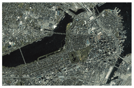
boston.tif copyright © GeoEye™, all rights reserved.
Input Arguments
filename — Name of GeoTIFF file
character vector | string scalar
Name of the GeoTIFF file, specified as a string scalar or character
vector. Include the folder name in filename or place the
file in the current folder or in a folder on the MATLAB® path. If the named file includes the extension
.TIF or .TIFF (either upper- or
lowercase), you can omit the extension from
filename.
idx — Index of image in GeoTIFF file
1 (default) | positive integer
Index of image in GeoTIFF file, specified as a positive integer. For
example, if idx is 3,
geotiffread reads the third image in the file. By
default, idx indexes to the first image in the
file.
url — Internet URL
character vector | scalar string
Internet URL, specified as a string scalar or character vector. The URL
must include the protocol type (e.g., "https://").
Output Arguments
A — Georeferenced image or data grid
M-by-N numeric matrix | M-by-N-by-P
numeric array
Georeferenced image or data grid, returned as one of the following:
An M-by-N numeric matrix
when the file contains a grayscale image or data grid
An
M-by-N-by-P
numeric array when the file contains a color image,
multispectral image, hyperspectral image, or data grid
The class of A depends on the storage class of the
pixel data in the file, which is related to the
BitsPerSample property as returned by the imfinfo function.
R — Spatial referencing object
geographic raster reference object | map raster reference object
Spatial referencing object, returned as one of the following.
A geographic raster reference object of type GeographicCellsReference or GeographicPostingsReference. This object is
returned when the image or data grid is referenced to a
geographic coordinate system.
A map raster reference object of type MapCellsReference or
MapPostingsReference. This object is returned when the
image or data grid is referenced to a projected coordinate
system.
X — Indexed image
M-by-N numeric matrix
Indexed image, returned as an M-by-N
numeric matrix.
cmap — Color map
c-by-3 numeric matrix
Color map associated with indexed image X, specified
as an c-by-3 numeric matrix. There are
c colors in the color map, each represented by a red,
green, and blue pixel value. Colormap values are rescaled into the range
[0,1].
refmat — Referencing matrix
3-by-2 numeric matrix | []
Referencing matrix, returned as 3-by-2 numeric matrix that transforms
raster row and column indices to or from geographic coordinates according
to:
[lon lat] = [row col 1] * refmat
refmat defines a (non-rotational, non-skewed)
relationship in which each column of the data grid falls along a meridian
and each row falls along a parallel. refmat must be
unambiguously defined by the GeoTIFF file, otherwise it and the bounding
box, bbox, are returned empty.
Data Types:double
bbox — Bounding box
2-by-2 numeric matrix | []
Bounding box, returned as a 2-by-2 numeric matrix that specifies the
minimum (row 1) and maximum (row 2) values for each dimension of the image
data in the GeoTIFF file. bbox is returned empty if
refmat is ambiguously defined by the GeoTIFF
file.
Data Types:double
Tips
geotiffread imports pixel data using the TIFF-reading
capabilities of the MATLAB function imread and likewise shares any
limitations of imread. Consult the imread
documentation for information on TIFF image support.
Compatibility Considerations
geotiffread is not recommended
Not recommended starting in R2020a
geotiffread is not recommended, except when reading a GeoTIFF
file from a URL or when reading multiple images from the same file. In other
situations, use readgeoraster instead. There are no plans to remove
geotiffread.
Unlike geotiffread, which returns a referencing matrix in
some cases, the readgeoraster function returns a raster
reference object. Reference objects have several advantages over referencing matrices.
Unlike referencing matrices, reference objects have properties that
document the size of the associated raster, its limits, and the
direction of its rows and columns. For examples of reference object
properties, see GeographicCellsReference and
MapPostingsReference.
You can manipulate the limits of rasters associated with reference
objects using the geocrop or mapcrop functions.
You can manipulate the size and resolution of rasters associated with
reference objects using the georesize or mapresize functions.
This table shows some typical usages of geotiffread and how
to update your code to use readgeoraster instead. Unlike
geotiffread, the readgeoraster
function requires you to specify a file extension. For example, use [Z,R] =
readgeoraster('boston.tif').
Not RecommendedRecommended[A,R] = geotiffread(filename);[A,R] = readgeoraster(filename);
[X,cmap,R] = geotiffread(filename);[X,R,cmap] = readgeoraster(filename);
[A,refmat,bbox] = geotiffread(filename);[A,R] = readgeoraster(filename);
xlimits = R.XWorldLimits;
ylimits = R.YWorldLimits;
bbox = [xlimits' ylimits'];
Introduced before R2006a


 3969
3969


 被折叠的 条评论
为什么被折叠?
被折叠的 条评论
为什么被折叠?
 到【灌水乐园】发言


