http://blog.csdn.net/mad1989/article/details/9933089
看标题就会明白,两个经纬度之间真实距离这个一般的地图API有自带方法,直接调用便可得到结果,一般结果都是以米为单位。最近在做android版上的GoogleMap,找了半天API发现没有此类方法,看来只能自己实现了,接下来我就把如何计算两点之间(经纬度)的真实距离的算法写下来,原则上在各种地图版本上都通用,方便大家使用。
Google Map API:https://developers.google.com/maps/documentation/android/
【本文适用于android,ios等各种平台下的地图经纬度测距】
自己实现距离算法:
- /**
- * 计算两点之间距离
- * @param start
- * @param end
- * @return 米
- */
- public double getDistance(LatLng start,LatLng end){
- double lat1 = (Math.PI/180)*start.latitude;
- double lat2 = (Math.PI/180)*end.latitude;
- double lon1 = (Math.PI/180)*start.longitude;
- double lon2 = (Math.PI/180)*end.longitude;
- // double Lat1r = (Math.PI/180)*(gp1.getLatitudeE6()/1E6);
- // double Lat2r = (Math.PI/180)*(gp2.getLatitudeE6()/1E6);
- // double Lon1r = (Math.PI/180)*(gp1.getLongitudeE6()/1E6);
- // double Lon2r = (Math.PI/180)*(gp2.getLongitudeE6()/1E6);
- //地球半径
- double R = 6371;
- //两点间距离 km,如果想要米的话,结果*1000就可以了
- double d = Math.acos(Math.sin(lat1)*Math.sin(lat2)+Math.cos(lat1)*Math.cos(lat2)*Math.cos(lon2-lon1))*R;
- return d*1000;
- }
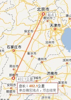
举例:(我使用的百度地图的经纬度数据)
- LatLng start = new LatLng(39.95676, 116.401394);
- LatLng end = new LatLng(36.63014,114.499574);
- getDistance(start, end);
log日志结果为:402.21321(km)
害怕不准确的话,可以打开百度地图首页,使用测距工具:
看图应该知道,应该没什么问题吧。


 1万+
1万+

 被折叠的 条评论
为什么被折叠?


