


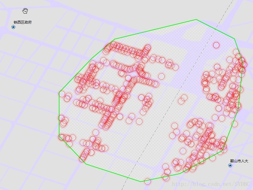
如下图所示:
实现代码如下:
<?xml version=”1.0″encoding=”utf-8″?>
<s:Application xmlns:fx=”http://ns.adobe.com/mxml/2009”
xmlns:s=”library://ns.adobe.com/flex/spark”
xmlns:mx=”library://ns.adobe.com/flex/mx”xmlns:supportClasses=”com.esri.ags.skins.supportClasses.*” minWidth=”955″minHeight=”600″ xmlns:esri=”http://www.esri.com/2008/ags“>
<fx:Script>
<![CDATA[
import com.esri.ags.FeatureSet;
import com.esri.ags.Graphic;
import com.esri.ags.components.Navigation;
import com.esri.ags.events.DrawEvent;
import com.esri.ags.geometry.MapPoint;
import mx.controls.Alert;
import mx.controls.Image;
import mx.events.ItemClickEvent;
import mx.rpc.AsyncResponder;
private var hashmapOfExistingGraphics:Object = new Object();
protected functiontbb_itemClickHandler(event:ItemClickEvent):void
{
switch (event.item.label)
{
case "POLYGON": {myDrawTool.activate(DrawTool.POLYGON); break; }
case "ELLIPSE": {myDrawTool.activate(DrawTool.ELLIPSE);
break; }
}
}
protected functionmyDrawTool_drawEndHandler(event:DrawEvent):void
{
//释放
query.geometry=event.graphic.geometry;
//graphicslayer.clear();
query.outSpatialReference = Map1.spatialReference;
queryTask.execute(query, new AsyncResponder(onResult,onFault));
myDrawTool.deactivate();
tbb.selectedIndex = -1;
}
private function onResult(featureSet:FeatureSet, token:Object= null):void
{
for each (var myGraphic:Graphic in featureSet.features)
{
// only add features that are not already in thegraphics layer
var graphicID:String = myGraphic.attributes.NAME;
if (!hashmapOfExistingGraphics[graphicID]) // Newfeature (not already added to graphics layer)
{
hashmapOfExistingGraphics[graphicID] = 1;
myGraphic.id = graphicID;
myGraphic.toolTip =myGraphic.attributes.NAME;
myGraphic.symbol=sps;
graphicslayer.add(myGraphic);
}
}
}
private function onFault(info:Object, token:Object =null):void
{
Alert.show(info.toString());
}
]]>
</fx:Script>
<fx:Declarations>
<!– 将非可视元素(例如服务、值对象)放在此处 –>
<esri:PictureMarkerSymbol id=”sps” source=”http://localhost/Red_glow.swf“ width=”20″ height=”20″ />
<esri:SimpleMarkerSymbol id=”sms”
color=”0x00FF00″
size=”12″
style=”square”/>
<!– Symbol for all line shapes –>
<esri:SimpleLineSymbol id=”sls”
width=”3″
color=”0x00FF00″/>
<!– Symbol for all polygon shapes –>
<esri:SimpleFillSymbol id=”sfs”
color=”0xFFFFFF”
style=”diagonalcross”>
<esri:outline>
<esri:SimpleLineSymbol width=”2″color=”0x00FF00″/>
</esri:outline>
</esri:SimpleFillSymbol>
<esri:QueryTask id=”queryTask”
showBusyCursor=”true”
url=”http://218.60.144.97:8080/RemoteRest/services/LN_SL/MapServer/9“
useAMF=”false”/>
<esri:Query id=”query”
outFields=”[NAME,ID]“
returnGeometry=”true”/>
<esri:DrawTool id=”myDrawTool” map=”{Map1}” drawEnd=”myDrawTool_drawEndHandler(event)” fillSymbol=”{sfs}”
graphicsLayer=”{graphicslayer}”
lineSymbol=”{sls}”
markerSymbol=”{sms}”/>
</fx:Declarations>
<esri:Map id=”Map1″ >
<!–<esri:ArcGISTiledMapServiceLayer
url=”http://server.arcgisonline.com/ArcGIS/rest/services/ESRI_StreetMap_World_2D/MapServer”/>–>
<esri:ArcGISDynamicMapServiceLayer url=”http://218.60.144.97:8080/RemoteRest/services/LN_SL/MapServer”/>
<esri:GraphicsLayer id=”graphicslayer”>
</esri:GraphicsLayer>
</esri:Map>
<mx:ToggleButtonBar id=”tbb” itemClick=”tbb_itemClickHandler(event)”toggleOnClick=”true”>
<fx:Object label=”POLYGON”/>
<fx:Object label=”ELLIPSE”/>
</mx:ToggleButtonBar>
</s:Application>


 6217
6217

 被折叠的 条评论
为什么被折叠?
被折叠的 条评论
为什么被折叠?
 到【灌水乐园】发言


