


Shapefile(.shp):
根本错误原因:
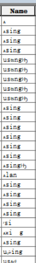
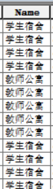
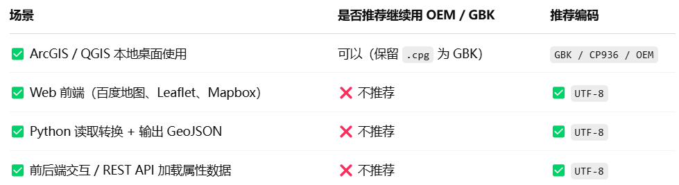
Shapefile 的属性数据 .dbf 是老旧格式,默认不含编码信息
解决方法:
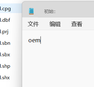
在shapefile文件夹目录上,创建一个同名的.cpg文件,内容"oem"
使用ArcGIS再右键打开属性表,正确编码✅
用于解决中文编码错误的shapefile_2_geojson脚本:
ps 代码不是通用模板,根据你的需求进行调整
import geopandas as gpd
import os
import json
from pyproj import CRS
import warnings
import codecs
warnings.filterwarnings('ignore')

def convert_shp_to_geojson(shp_path, output_path):
    """
    将 Shapefile 转换为 WGS84 坐标系的 GeoJSON

    参数:
        shp_path: Shapefile 文件路径
        output_path: 输出 GeoJSON 文件路径
    """
    print(f"正在处理: {shp_path}")

    try:
        # 检查是否存在CPG文件,如果不存在则创建
        cpg_path = shp_path.replace('.shp', '.cpg')
        if not os.path.exists(cpg_path):
            print("未找到CPG文件,创建CPG文件指定编码为GBK")
            with open(cpg_path, 'w') as f:
                f.write("GBK")
        else:
            # 读取现有CPG文件内容
            with open(cpg_path, 'r') as f:
                encoding = f.read().strip()
                print(f"检测到CPG文件,编码为: {encoding}")

        # 读取CPG文件获取编码
        with open(cpg_path, 'r') as f:
            encoding = f.read().strip()

        print(f"使用编码 {encoding} 读取Shapefile")

        # 使用CPG中指定的编码读取Shapefile
        gdf = gpd.read_file(shp_path, encoding=encoding)

        # 检查坐标系
        if gdf.crs is None:
            print("警告: 未检测到坐标系,尝试从 .prj 文件解析")
            # 尝试从 .prj 文件读取坐标系
            prj_path = shp_path.replace('.shp', '.prj')
            if os.path.exists(prj_path):
                with open(prj_path, 'r') as f:
                    prj_text = f.read()
                    try:
                        crs = CRS.from_wkt(prj_text)
                        gdf.set_crs(crs, inplace=True)
                        print(f"从 .prj 文件解析坐标系: {crs.name}")
                    except Exception as e:
                        print(f"解析 .prj 文件失败: {str(e)}")
                        # 假设为北京54投影坐标系
                        gdf.set_crs("+proj=tmerc +lat_0=0 +lon_0=117 +k=1 +x_0=500000 +y_0=0 +ellps=krass +units=m +no_defs", inplace=True)
                        print("已设置为默认北京54投影坐标系(3度带,中央经线117°)")
            else:
                # 假设为北京54投影坐标系
                gdf.set_crs("+proj=tmerc +lat_0=0 +lon_0=117 +k=1 +x_0=500000 +y_0=0 +ellps=krass +units=m +no_defs", inplace=True)
                print("未找到 .prj 文件,已设置为默认北京54投影坐标系(3度带,中央经线117°)")

        # 输出原始坐标系信息
        print(f"原始坐标系: {gdf.crs}")

        # 转换为 WGS84 坐标系 (EPSG:4326)
        if gdf.crs.to_epsg() != 4326:
            print("转换坐标系为 WGS84 (EPSG:4326)")
            gdf = gdf.to_crs(epsg=4326)

        # 处理二进制数据
        for col in gdf.columns:
            if col == 'geometry':
                continue

            # 处理bytes类型数据
            gdf[col] = gdf[col].apply(
                lambda x: x.decode(encoding, errors='replace') if isinstance(x, bytes) else str(x) if x is not None else None
            )

        # 转换为 GeoJSON - 移除不支持的force_ascii参数
        geojson_str = gdf.to_json()
        geojson_data = json.loads(geojson_str)

        # 保存 GeoJSON 文件,添加 BOM 标记
        with codecs.open(output_path, 'w', encoding='utf-8-sig') as f:
            json.dump(geojson_data, f, ensure_ascii=False, indent=2)

        print(f"成功转换并保存到: {output_path}")
        print(f"使用 UTF-8 with BOM 编码保存,确保中文正确显示")
        return True

    except Exception as e:
        print(f"转换失败: {str(e)}")
        import traceback
        traceback.print_exc()
        return False

if __name__ == "__main__":
    # 设置 Shapefile 文件夹路径
    shp_folder = r"你的路径"
    output_folder = r"你的路径"

    # 确保输出文件夹存在
    os.makedirs(output_folder, exist_ok=True)

    # 获取所有 .shp 文件
    shp_files = [f for f in os.listdir(shp_folder) if f.endswith('.shp')]
    print(f"找到 {len(shp_files)} 个 Shapefile 文件")

    # 转换每个文件
    for shp_file in shp_files:
        shp_path = os.path.join(shp_folder, shp_file)
        output_path = os.path.join(output_folder, shp_file.replace('.shp', '.geojson'))
        convert_shp_to_geojson(shp_path, output_path)


 3399
3399

 被折叠的 条评论
为什么被折叠?
被折叠的 条评论
为什么被折叠?
 到【灌水乐园】发言


