


概述
本文讲述如何在OL3中叠加展示PNG图片。
实现思路
在OL3中,可通过ImageStatic资源来添加展示一个PNG图片,代码如下:
		image = new ol.layer.Image({
	            source: new ol.source.ImageStatic({
	               url: "img/china2.png",
	               imageExtent: extent
	            })
	        })
在此过程中,需要注意PNG图片的四至,即最大/最小经纬度,例如图片的四至信息如下:
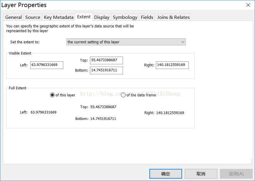
代码中,定义extent的时候,extent的定义如下:
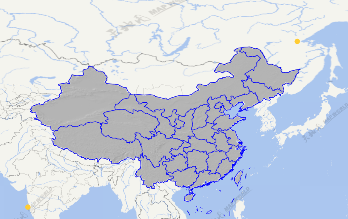
var extent = [63.9796331669, 14.7451916711, 140.1812559169, 55.4673388687];实现后如下:
实现代码
	<script type="text/javascript">
		var map, image;
		function init(){
			var bounds = [72.985, 17.006, 134.416, 54.815];
			var extent = [63.9796331669, 14.7451916711, 140.1812559169, 55.4673388687];
			image = new ol.layer.Image({
	            source: new ol.source.ImageStatic({
	               url: "img/china2.png",
	               imageExtent: extent
	            })
	        })

			var projection = new ol.proj.Projection({
				code: 'EPSG:4326',
				units: 'degrees'
			});
			var vec_c = getTdtLayer("vec_w");
			var province = new ol.layer.Image({
		        source: new ol.source.ImageWMS({
			          ratio: 1,
			          url: 'http://10.16.48.185:8086/geoserver/my_test/wms',
			          params: {
			          		'FORMAT': 'image/png',
			                'VERSION': '1.1.1',
			                STYLES: '',
			                LAYERS: 'my_test:province_line',
			          }
		        })
		    });
			map = new ol.Map({
				controls: ol.control.defaults({
					attribution: false
				}),
				target: 'map',
				layers: [vec_c,image,province],
				view: new ol.View({
					projection: projection,
					minZoom:4,
					maxZoom:18
				})
			});
			map.getView().fit(bounds, map.getSize());
		}

		function getTdtLayer(lyr){
			var url = "http://t0.tianditu.com/DataServer?T="+lyr+"&X={x}&Y={y}&L={z}";
    		var layer = new ol.layer.Tile({
				source: new ol.source.XYZ({
			        url:url
			    })
			});
			return layer;
		}
	</script>
-------------------------------------------------------------------------------------------------------------
技术博客
CSDN:http://blog.csdn.NET/gisshixisheng
博客园:http://www.cnblogs.com/lzugis/
在线教程
http://edu.csdn.Net/course/detail/799
Github
https://github.com/lzugis/
联系方式
q q:1004740957
e-mail:niujp08@qq.com
公众号:lzugis15
Q Q 群:452117357(webgis)
337469080(Android)


 1536
1536

 被折叠的 条评论
为什么被折叠?
被折叠的 条评论
为什么被折叠?
 到【灌水乐园】发言


