


这篇说下,如何使用高德来实现行政区划查询并划出行政区的范围,实现参考了官网的案例,不过官网的案例是html写的,我这里用vue实现。
官网案例:行政区边界查询示例
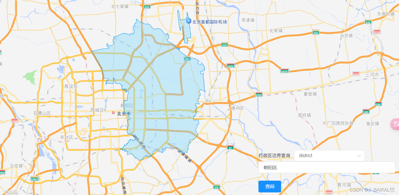
一、最终效果:
二、页面完整代码:
<template>
  <div>    <div id="container" ref="amap"></div>


    <div class="input-card-container">
      <el-form @submit.prevent="onSubmit" class="input-card">
        <el-form-item label="行政区边界查询" style="color: grey;">
          <el-select v-model="level" placeholder="请选择行政级别">
            <el-option value="district">district</el-option>
            <el-option value="city">city</el-option>
            <el-option value="province">province</el-option>
          </el-select>
          <!--        <el-input v-model="district" placeholder="请输入名称或adcode"></el-input>-->
          <el-input v-model="keyWord" placeholder="请输入名称或adcode"></el-input>

        </el-form-item>
        <el-button type="primary" @click="onSubmit">查询</el-button>
      </el-form>    </div>

  </div>

</template>

<script>

  //安全密钥
  window._AMapSecurityConfig = {
    securityJsCode: "安全密钥",
  };

  import AMapLoader from '@amap/amap-jsapi-loader';
  export default {
    name: "Class",
    data() {
      return {
        level:'district',
        district:null,
        polygon:null,
        keyWord:'朝阳区',
      };
    },
    created() {
      this.initAMap();

    },
    methods: {

      initAMap() {
        AMapLoader.load({
          key: 'key', // 申请好的Web端开发者Key,首次调用 load 时必填
          version: '2.0', // 指定要加载的 JSAPI 的版本,缺省时默认为 1.4.15          plugins: ['AMap.DistrictSearch','AMap.Polygon']  // 需要使用的的插件列表,如比例尺'AMap.Scale'等,如果是地图控件,必须再 map.addControl添加
        })
          .then((AMap) => {
            this.map = new AMap.Map('container', {
              // 设置地图容器id
              //viewMode: '3D', // 默认2d地图模式
              zoom: 12, // 初始化地图级别
              zooms: [5, 30], // 地图缩放范围
              // 可以设置初始化当前位置
              center: [116.397428, 39.90923] // 初始化地图位置
            })
          })
      },
      /**绘制区域*/
      drawBounds() {
        if (!this.district) {
          var opts = {
            subdistrict: 0,
            extensions: 'all',
            level: this.level // 使用数据属性 level          };
          this.district = new AMap.DistrictSearch(opts);
        }

        if (!this.keyWord) {
          console.warn('名称不能为空');
          return;        }

        // this.district.setLevel(this.level); // 使用数据属性 level
        this.district.level=this.level;
        console.log(this.district,"district-----------")
        //行政区查询
        this.district.search(this.keyWord, (status, result) => { // 使用箭头函数保留 this 上下文
          if (this.polygon) {
            this.map.remove(this.polygon); // 使用 this.map            this.polygon = null;
            //status:complete 表示查询成功,no_data 为查询无结果,error 代表查询错误
            //查询成功时,result 即为对应的行政区信息
          }

          console.log(result,"result---------")
          if (!result || !result.districtList || !result.districtList[0]) {
            console.warn('请正确填写名称或更新其他名称');
            return;          }

          const bounds = result.districtList[0].boundaries;
          if (bounds) {
            for (let i = 0; i < bounds.length; i += 1) {
              bounds[i] = [bounds[i]];
            }

            this.polygon = new AMap.Polygon({
              strokeWeight: 1,
              path: bounds,
              fillOpacity: 0.4,
              fillColor: '#80d8ff',
              strokeColor: '#0091ea'
            });

            this.map.add(this.polygon);
            this.map.setFitView(this.polygon);
          }
        });
      },


      onSubmit(){
        this.drawBounds(); // 在表单提交时调用 drawBounds 方法
      },


    }
  };
</script>

<style scoped lang="scss">
  #container {
    padding: 0px;
    margin: 0px;
    width: 100%;
    height: 900px;
    position: relative;
  }
  .input-card-container {
    /*position: absolute;*/
    position: fixed;
    bottom: 20px;
    right: 20px;
    z-index: 1;
  }
</style>
三、遇到的问题
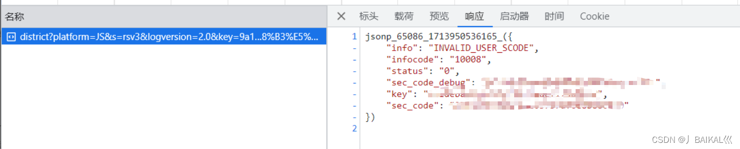
代码没有问题,也没有报错
发现发送查询行政区请求时 INVALID_USER_SCODE(无效用户代码)
jsonp_65086_1713950536165_({
    "info": "INVALID_USER_SCODE",
    "infocode": "10008",
    "status": "0",
    "sec_code_debug": "",
    "key": "",
    "sec_code": ""
})
原因:
只是用了key,没有使用安全密钥
key和安全密钥需要一起使用才可以

解决:
在前端<script>标签中,也就是import上面添加以下代码就可以了
window._AMapSecurityConfig = {
  securityJsCode: "安全密钥",
};


 3319
3319

 被折叠的 条评论
为什么被折叠?
被折叠的 条评论
为什么被折叠?
 到【灌水乐园】发言


