


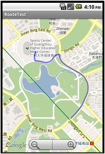
android在google map上画线比较容易实现的,但是现在问题在于如何获取起点和终点之间的路线图。这里我们使用Google Directions API来实现, Google Directions API是一种使用 HTTP 请求计算多个位置间路线的服务。路线可以以文本字符串或纬度/经度坐标的形式指定起点、目的地和路标。Google Directions API 可以使用一系列路标传回多段路线。
Google Directions API 请求是以下形式的 HTTP 网址:http://maps.google.com/maps/api/directions/output?parameters
其中,output 可能是以下任何一个值:
l json(建议)表示以 JavaScript 对象表示法 (JSON) 的形式输出
l xml 表示以 XML 的形式输出
具体参数参见http://code.google.com/intl/zh-CN/apis/maps/documentation/directions/
通过http请求获取线路,接下来我们需要对返回结果进行解析,提取出导航线路的一系列路标。
如果我们只是简单的画图路线路,返回结果中的字段overview_path包含可我们所需要的数据。它包含一个对象,该对象包含一组表示生成路线的近似(平滑)路径的已编码 points 和 levels。编码算法参见http://code.google.com/intl/zh-CN/apis/maps/documentation/utilities/polylinealgorithm.html说明。
我们只需要提取points字段中的字符串进行解码就可以得到我们所需的一系列点了,将这些点按顺序连接起来就是我们所要的路线图了。
- /**
- * 通过解析google map返回的xml,在map中画路线图
- */
- public void drawRoute(){
- String url = "http://maps.google.com/maps/api/directions/xml?origin=23.055291,113.391802" +
- "&destination=23.046604,113.397510&sensor=false&mode=walking";
- HttpGet get = new HttpGet(url);
- String strResult = "";
- try {
- HttpParams httpParameters = new BasicHttpParams();
- HttpConnectionParams.setConnectionTimeout(httpParameters, 3000);
- HttpClient httpClient = new DefaultHttpClient(httpParameters);
- HttpResponse httpResponse = null;
- httpResponse = httpClient.execute(get);
- if (httpResponse.getStatusLine().getStatusCode() == 200){
- strResult = EntityUtils.toString(httpResponse.getEntity());
- }
- } catch (Exception e) {
- return;
- }
- if (-1 == strResult.indexOf("<status>OK</status>")){
- Toast.makeText(this, "获取导航路线失败!", Toast.LENGTH_SHORT).show();
- this.finish();
- return;
- }
- int pos = strResult.indexOf("<overview_polyline>");
- pos = strResult.indexOf("<points>", pos + 1);
- int pos2 = strResult.indexOf("</points>", pos);
- strResult = strResult.substring(pos + 8, pos2);
- List<GeoPoint> points = decodePoly(strResult);
- MyOverLay mOverlay = new MyOverLay(points);
- List<Overlay> overlays = mMapView.getOverlays();
- overlays.add(mOverlay);
- if (points.size() >= 2){
- mMapController.animateTo(points.get(0));
- }
- mMapView.invalidate();
- }
- /**
- * 解析返回xml中overview_polyline的路线编码
- *
- * @param encoded
- * @return
- */
- private List<GeoPoint> decodePoly(String encoded) {
- List<GeoPoint> poly = new ArrayList<GeoPoint>();
- int index = 0, len = encoded.length();
- int lat = 0, lng = 0;
- while (index < len) {
- int b, shift = 0, result = 0;
- do {
- b = encoded.charAt(index++) - 63;
- result |= (b & 0x1f) << shift;
- shift += 5;
- } while (b >= 0x20);
- int dlat = ((result & 1) != 0 ? ~(result >> 1) : (result >> 1));
- lat += dlat;
- shift = 0;
- result = 0;
- do {
- b = encoded.charAt(index++) - 63;
- result |= (b & 0x1f) << shift;
- shift += 5;
- } while (b >= 0x20);
- int dlng = ((result & 1) != 0 ? ~(result >> 1) : (result >> 1));
- lng += dlng;
- GeoPoint p = new GeoPoint((int) (((double) lat / 1E5) * 1E6),
- (int) (((double) lng / 1E5) * 1E6));
- poly.add(p);
- }
- return poly;
- }


 897
897


 被折叠的 条评论
为什么被折叠?
被折叠的 条评论
为什么被折叠?
 到【灌水乐园】发言


