


目录
一、卫星简介
CALIPSO (Cloud–Aerosol Lidar and Infrared Path nder Satellite Observation) 是NASA和CNES 太阳轨道地球侦察卫星。CALIPSO搭载3个天顶视场的仪器(CALIOP, IIR, WFC),用于观测气溶胶和微米级的云粒。CALIPSO携带的可见光和近红外偏振传感器激光雷达用于观察地球气溶胶和云的相态。卫星数据分发格式为HDF和HDF-EOS,有不同级别的数据产品可供选择。
是与CloudSat同时发射升空的卫星,同属于A-Train系列卫星,其轨道与CloudSat相同,仅落后CloudSat卫星10-15 s。它是首颗搭载532、1064 nm波段的双通道的云-气溶胶正交偏振激光雷达(Cloud-Aerosol Lidar with Orthogonal Polarization,CALIOP)的卫星,能够同时测得高空的微弱水汽凝结层以及光学厚度较薄的冰云,因而与CloudSat结合能探测到更为完整的云垂直结构。
二、数据下载网址
1.https://asdc.larc.nasa.gov/project/CALIPSO/CAL_LID_L2_VFM-Standard-V4-20_V4-20
2.https://subset.larc.nasa.gov/calipso/login.php  ###需要注册(快)
3.https://search.earthdata.nasa.gov/search
网站一: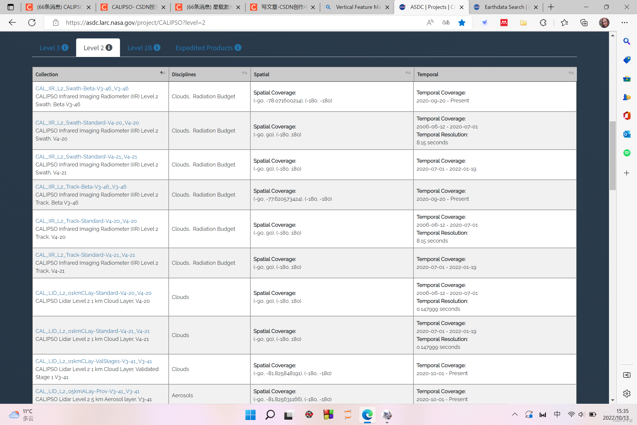
网站二:
网站三:

#这个网站可以看到CALIPSO的各个数据等级的产品对应有哪些产品
#可以先在这里筛选符合我们要求的chanpin
https://asdc.larc.nasa.gov/project/CALIPSO
三、数据说明
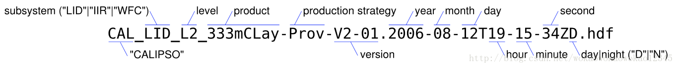
3.1 CALIPSO 数据产品命名规则 (v4.x)
[Investigation]_[Subsystem]_[Level]_[ProductID]-[ProductionStrategy]-[Version].[Instance].hdf
Investigation = Mission Name: CAL(CALIPSO mission)
Subsystem = LID(Lidar) | IIR | WFC
Level = Product Level: L0 | L1 | L2 | L3 | L15
ProductID = Product Identification: 1Km | 125m | VFM | 333mCLay | 01kmCLay | 05kmCLay |05kmALay | 05kmAProCal | 05kmCPro | PSCMask | Ice_Cloud | Stratospheric_APro |
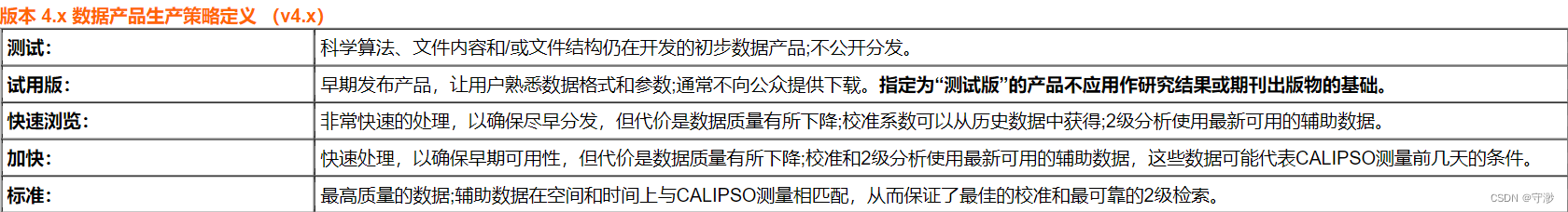
ProductionStrategy = Test | Beta | Quick Look | Expedited | Standard
Version = Version Information, e.g., V4-10
Instance = YYYY-MM-DDThh-mm-ssZ[D|N] | YYYY-MM[D|N|A] | YYYY-MM
File Format = Hiearchical Data Format: .hdf
ex:CAL_LID_L2-05kmAPro-Prov-Standard-V3-01-10.2010-04-17T20-09-13ZN.hdf
即:CALIPSO激光雷达CALIOP的Level2 5km分辨率的气溶胶廓线产品,版本是V3,发布时 间是2010年4月17日20时9分13秒夜晚的观测数据

具体请看:
CALIPSO产品描述:
https://www-calipso.larc.nasa.gov/resources/calipso_users_guide/data_summaries/index.php
激光雷达浏览图像教程:
https://www-calipso.larc.nasa.gov/resources/calipso_users_guide/browse/index.php
产品描述:CALIPSO - Users Guide (nasa.gov)
3.2 数据产品(Essential Reading)
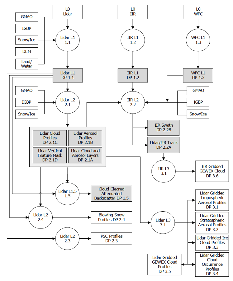
圆圈中的数字表示生产子系统(production subsystems)。以 DP(Data Product)为前缀的数字是本文档中标识的部分。实心阴影区域表示在标准版和加急版中(Standard and Expedited versions)都可用的数据产品。 lidar level 2 PSC data, lidar level 2 Blowing Snow data, and Level 3 data 仅作为标准产品分发。
Level 2 Layer Data
The level 2 analyses of the CALIOP lidar backscatter data begins with an attempt to locate all coherent “features” - i.e., clouds and aerosol layers - in each granule of the level 1 data. The results of this search are reported in four different lidar level 2 layer products. Cloud layers are reported at three different horizontal averaging resolutions: 1/3-km, 1-km, and 5-km.
The 1/3-km data is reported only in those regions where single shot information is available in the downlinked data; that is, between ~8.2km and -0.5km. The 1-km and 5-km cloud layers are reported between ~20.2 and -0.5-km. Aerosol layers are reported between at a 5-km horizontal resolution between ~30.1-km and -0.5km. Layers detected in the stratosphere are recorded in the aerosol layer products, and thus users seeking measurements of polar stratospheric clouds should order the 5-km aerosol layer products. Note that the layers reported in the 5 km horizontal resolution data products may have been required averaging to as much as 80 horizontally before being detected by the feature finder algorithm. However, these fainter layers are still reported on the same uniform 5-km horizontal grid. To effectively use the 5-km layer products, users should first thoroughly familiarize themselves with the multi-gridded averaging scheme described here and in the feature finder ATBD.
Vertical and Horizontal Resolution of the Lidar data
The CALIPSO lidar collects profile data at a nominal(名义上的) vertical resolution of 15 m(15m的垂直分辨率) (10 MHz sampling rate 采样率), and at a laser pulse repetition rate of 20.16 Hz(20.16Hz的激光脉冲重复率), which when accounting the satellites orbital velocity, translates into a horizontal profile spacing of <9C>333 m. Within the lower atmosphere the footprint of each profile is <9C>90 m in diameter. Due to bandwidth limitations for downlinking the data from the satellite, the data is averaged on-board the satellite in both the horizontal and vertical dimensions.
The purpose of the on-board averaging scheme is to maximize spatial resolution and dynamic range of the signal while minimizing the telemetry data volume. The resulting algorithm reduced the required telemetry bandwidth by more than an order of magnitude relative to the raw data, with minimum impact on the information content of the data. Unfortunately, this comes at a price in terms of complexity in the telemetry data.
The on-board averaging scheme provides the highest resolution in the lower troposphere where the spatial variability of clouds and aerosols is the greatest and coarser resolutions higher in the atmosphere. The degree of averaging varies with altitude, as detailed in the figure below.
机载平均方案在对流层低层提供了最高的分辨率,在那里云和气溶胶的空间变异性最大,在大气中分辨率较高。平均程度随海拔的不同而不同,详见下图。

左图:15个连续的全分辨率激光雷达剖面图(即水平距离为5公里)的示意图,五种不同的平均制度是使用五种不同深浅的蓝色显示的。每个蓝色带内的垂直线描绘了通过水平平均全分辨率数据创建的各个剖面。例如,在8.2-km和20.2-km之间,数据水平平均,标称空间分辨率为1km;i、 即,对来自3个全分辨率(333m)剖面的数据进行平均,以创建每个1km平均剖面段。同样,在20.2km和30.1km之间,平均5个全分辨率(333m)剖面,以创建3个剖面,每个剖面跨越标称水平范围5/3km。垂直方向的处理以类似的方式进行,如各高度范围内最右侧剖面图中显示的细水平黑线所示。
The table in the middle gives the numerical values of the horizontal and vertical averaging for all the altitude regions. The highest resolution data available is in the region between -0.5 and 8.5 km which is provided at 333 m horizontally and 30 m in the vertical.
中图:给出了所有海拔区域的水平和垂直平均值的数值。可用的最高分辨率数据位于-0.5至8.5 km之间的区域,水平方向333 m,垂直方向30 m。
During level 1 processing the data is regridded to a uniform horizontal grid of 333 m (see the right hand image above); however, the vertical (i.e. altitude) resolution remains identical to that of the downlinked data. Thus even though the level 1B profile data is reported at a uniform horizontal resolution of 333 m, in regions above 8.5 km it is over sampled. For example, to create 15 “pseudo single shot” profiles in the altitude region between 8.5 km to 20.1 km, the downlinked 1 km profiles in this region are replicated and grafted onto the top of three consecutive full resolution (single shot) profiles.
右图:在level 1 处理期间,数据被重新划分为333 m的均匀水平网格;然而,垂直(即高度)分辨率仍然与下行数据的分辨率相同。因此,尽管报告的1B级剖面数据具有333 m的统一水平分辨率,但在8.5 km以上的区域,其采样过多。例如,为了在8.5 km到20.1 km之间的海拔区域创建15个“伪单炮”剖面,该区域的下行链路1 km剖面被复制并嫁接到三个连续全分辨率(单炮)剖面的顶部。
The preceding commentary refers specifically to the 532 nm parallel and perpendicular channels only. The 1064 nm channel is recorded at a vertical resolution of 60 m in the range be -0.5 and 8.2 km, also no 1064 nm data is available above 20.1 km.
前面的评注专门提到532 nm平行和垂直通道。1064 nm通道的垂直分辨率为60 m,范围为-0.5 km和8.2 km,在20.1 km以上也没有1064 nm数据可用。
Detailed information about the altitude array and vertical and horizontal averaging of the data users are encouraged to read section 2.3 in the Lidar Level 1 ATBD or Section 3.3 in the mission overview document.
有关高度阵列以及数据用户的垂直和水平平均值的详细信息,鼓励阅读激光雷达1级ATBD中的第2.3节或任务概述文档中的第3.3节。
In all of the profile data sets the altitude array can be found in the metadata field (VDATA) called Lidar_Data_Altitudes.
在所有剖面图数据集中,可以在称为Lidar_Data_Altitudes的元数据字段 (VDATA) 中找到海拔阵列。
四、python资料参考
微信推文:https://mp.weixin.qq.com/s/Q959PFXPZhb6gt6v43TTbA
来自官网的综合实例:http://hdfeos.org/zoo/index_openLaRC_Examples.php#CALIPSO


 715
715


 被折叠的 条评论
为什么被折叠?
被折叠的 条评论
为什么被折叠?
 到【灌水乐园】发言


