


参考链接:
[1] https://blog.csdn.net/hitwhylz/article/details/23089415
[2] https://zhuanlan.zhihu.com/p/51099376
仿真平台:MATLAB R2018b
说明:算法在点阵图中进行,一个像素相当于一个方格(节点),每个方格周围的8个方格为可到达的方格。启发函数采用曼哈顿距离。
主程序代码main_Astar.m:
%***************************************
%Author: Yiming OU   ——2021.06.21
%Filename: main_Astar.m
%***************************************
clear;
clc;

% 初始化地图
pic = imread('map.png');  %读取图像
pic_gray = rgb2gray(pic);
thresh = 0.9;  % 根据实际需求取值
map = imbinarize(pic_gray, thresh); % thresh=0.5 表示将灰度128以下的像素全部变为黑色,灰度在128以上的像素全部变为白色。
map = imcomplement(map);   %二值取反

%起点坐标和目标点坐标[x, y],分别对应列序号和行序号
q_start = [50, 50];
q_goal =  [450, 450];
%% 路径规划

tic

[edges, path, vertices] = Astar(map, q_start, q_goal);%A*算法

toc


% 计算路径长度
lengthofpath = 0;
[path_num, ~] = size(path);
for n = 2 : path_num

    lengthofpath = lengthofpath + norm(double(path(n-1, :)) - double(path(n, :)));

end

%% 画图
    imshow(int32(1 - map), []);
    title('A*');


    hold on;

    [edgesRowCount, ~] = size(edges);

    for ii = 1 : edgesRowCount
        plot(vertices(ii, 1), vertices(ii, 2),  'cyan.', 'linewidth', 1);

    end

    plot(q_start(1), q_start(2), 'rp', 'linewidth', 1);
    plot(q_goal(1), q_goal(2), 'r*', 'linewidth', 1);


    [pathCount, ~] = size(path);

    for ii = 1 : pathCount - 1
        plot(path(ii, 1), path(ii, 2), 'r.', 'linewidth', 1);

    end
相关函数代码Astar.m:
%***************************************
%Author: Yiming OU   ——2021.06.21
%Filename: Astar.m
%***************************************
function [edges, path, vertices] = Astar(map, q_start, q_goal)

    if nargin < 3
        error('输入参数不足,请提供地图、起点和终点信息');
    end

    checkInput(map, q_start, q_goal);

    [~,mapWidth] = size(map); %地图的宽度

    list = zeros(size(map)); %0代表未探索,1代表open,2代表close

    index_start = index(q_start, mapWidth);  %起始点序号
    index_goal = index(q_goal, mapWidth);  %目标点序号

    edges = int32.empty(0, 2);  %1,2列分别为子节点和父节点序号

    vertices = q_start;  %存放所有遍历过的节点

    k = numel(map);  %总节点数
    q_father = q_start;

    %存放节点估计代价,各行分别为节点序号、到起点距离、到目标点曼哈顿距离、估计代价
    CostTable = [index_start; 0; Mdistance(q_start, q_goal); Mdistance(q_start, q_goal)];

    for ii = 1 : k
        costOfQNew = Inf;

        index_father = index(q_father, mapWidth);
        list(q_father(2), q_father(1)) = 2;

        %遍历父节点周围的可到达节点
        for i = -1 : 1
            for j = -1 : 1

                q_son = q_father + [i, j];

                index_son = index(q_son, mapWidth);

                if ~isNodeFree(map, q_son) || list(q_son(2), q_son(1)) == 2
                    %子节点位于障碍物或CloseList中
                    continue;
%                 elseif isNodeTrapped(q_son, map, list)
%                     %子节点没有潜在的子节点
%                     continue;
                end

                if isequal(q_son, q_goal)
                    edges = [edges; [index_son, index_father]];
                    %找到目标点,生成路径
                    path = findPath(edges, index_start, mapWidth);
                    return;
                end

                %计算子节点经q_father的估计代价
                [EdOfQSon, MdOfQSon, costOfQSon] = cost(q_son, q_father, index_father, CostTable, q_goal);

                if list(q_son(2), q_son(1)) == 1
                    %子节点在OpenList中
                    [~, column] = find(CostTable(1, :) == index_son);
                    if costOfQSon >= CostTable(4, column)
                        costOfQSon = CostTable(4, column);
                    else
                        %更新父节点
                        [row, ~] = find(edges(:, 1) == index_son);
                        edges(row, :) = [];
                        edges = [edges; [index_son, index_father]];

                        CostTable(:, column) = [];
                        CostTable = [CostTable, [index_son; EdOfQSon; MdOfQSon; costOfQSon]];
                    end
                else
                    %子节点未探索过,直接放入edges
                    edges = [edges; [index_son, index_father]];

                    CostTable = [CostTable, [index_son; EdOfQSon; MdOfQSon; costOfQSon]];

                    list(q_son(2), q_son(1)) = 1;

                    vertices = [vertices; q_son];
                end

                if costOfQSon < costOfQNew
                    %找到所有可到达节点中估计代价最小者
                    q_new = q_son;
                    index_new = index_son;

                    costOfQNew = costOfQSon;
                end
            end
        end
        q_father = q_new;
    end

    error('未找到路径。');
end

% 输入参数检查
function checkInput(map, q_start, q_goal)

    [mapHeight, mapWidth] = size(map);

    if mapWidth < 1 || mapHeight < 1
        error('地图尺寸有误,请检查是否输入了正确的二维地图。');
    end

    [x, y] = size(q_start);
    if x ~= 1 || y ~= 2
        error('点坐标应为1×2矩阵,如:[20, 30]。');
    elseif q_start(1) < 0 || q_start(1) > mapWidth || q_start(2) < 0 || q_start(2) > mapHeight
        error('点坐标不能超出地图范围。');
    end

    [x, y] = size(q_goal);
    if x ~= 1 || y ~= 2
        error('点坐标应为1×2矩阵,如:[20, 30]。');
    elseif q_goal(1) < 0 || q_goal(1) > mapWidth || q_goal(2) < 0 || q_goal(2) > mapHeight
        error('点坐标不能超出地图范围。');
    end
end

%节点编号
function [in] = index(q, mapWidth)
    in = mapWidth*(q(2)-1)+q(1);
    in = int32(in);
end

%相邻可到达节点之间欧氏距离
function [Ed] = Edistance(q1, q2)
    q1_q2 = q1 - q2;
    if q1_q2(1) == 0 && q1_q2(2) == 0
        Ed = 0;
    elseif q1_q2(1) == 0 || q1_q2(2) == 0
        Ed = 10;
    else
        Ed = 14;
    end

    Ed = int32(Ed);
end

% 两节点之间曼哈顿距离
function [Md] = Mdistance(q1, q2)
    q1_q2 = q1 - q2;
    Md = abs(q1_q2(1)) + abs(q1_q2(2));
    Md = Md * 10;
    Md = int32(Md);
end

% 计算子节点的估计代价
function [di2start, Md2goal, co] = cost(q_son, q_father, index_father, CostTable, q_goal)

    [~, column] = find(CostTable(1, :) == index_father); %存放父节点代价信息列向量的列序号
    di2start = int32(CostTable(2, column)) + Edistance(q_son, q_father);
    Md2goal = Mdistance(q_son, q_goal);

    co = int32(di2start + Md2goal);

end

% 节点是否为自由区域,1代表是,0代表否
function [isFree] = isNodeFree(map, q)
    [mapHeight, mapWidth] = size(map);
    if q(1) < 1 || q(2) < 1 || q(1) > mapWidth || q(2) > mapHeight
        isFree = 0;
    else
        isFree = ~map(q(2), q(1));
    end
end

%将节点序号转换为坐标
function coordinate = index2node(index, mapWidth)
    x = int32(mod(index, mapWidth));
    if x == 0
        x = mapWidth;
    end

    y = int32((index-x)/mapWidth + 1);

    coordinate = [x, y];
end


%找到组成路径的节点
function [path] = findPath(edges, index_start, mapWidth)

    [edge_num, ~] = size(edges);
    index_son = edges(end, 1);
    index_father = edges(end, 2);
    path = index2node(index_son, mapWidth);

    for i = 1 : edge_num

        [row, ~] = find(edges(:, 1) == index_father);

        index_son = index_father;
        path = [path; index2node(index_son, mapWidth)];

        index_father = edges(row, 2);

        if index_father == index_start
            path = [path; index2node(index_start, mapWidth)];

            break;
        end
    end

    path = flipud(path);
end

% 判断节点是否拥有子节点
% function [isN] = isNodeTrapped(q, map, list)
%
%     for i = -1 : 1
%         for j = -1 : 1
%
%             if ~i && ~j
%                 continue;
%             end
%
%             q_son = q + [i, j];
%             if isNodeFree(map, q_son) && list(q_son(2), q_son(1)) ~= 2
%                 isN = 0;
%
%                 return;
%             end
%         end
%     end
%
%     isN = 1;
% end
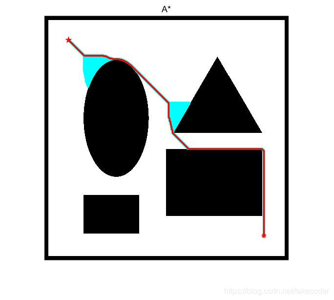
仿真:首先画一张500×500的地图(内有橙色障碍物),保存为map.png。

将main_Astar.m、Astar.m、map.png置于同一路径,直接运行main_Astar.m即可得到结果。红色为路径,浅蓝色为遍历过的方格(像素点)。
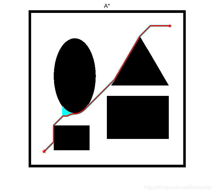
将起始点和终点加以改变,又可得到下面结果:


 被折叠的 条评论
为什么被折叠?
被折叠的 条评论
为什么被折叠?
 到【灌水乐园】发言


