


 本文详细介绍使用天地图API进行地图绘制的过程,包括获取开发者密钥、绘制基本地图、添加缩放和平移控件、自定义图片标注以及实现信息窗口等功能。通过实际代码示例,帮助读者快速掌握天地图API的基本操作。
-
使用准备
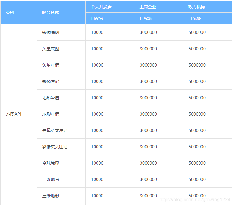
申请成为个人开发者或者企业开发者,获取调用地图api的key,下图为调用限额对比图。
-
开始绘制第一个地图
<!DOCTYPE html>
<html>
<head>
<meta http-equiv="content-type" content="text/html; charset=utf-8"/>
<meta name="keywords" content="天地图"/>
<title>天地图-地图API-范例-经纬度直投地图</title>
<script type="text/javascript" src="http://api.tianditu.gov.cn/api?v=4.0&tk=您的密钥"></script>
<style type="text/css">body,html{width:100%;height:100%;margin:0;font-family:"Microsoft YaHei"}#mapDiv{width:100%;height:400px}input,b,p{margin-left:5px;font-size:14px}</style>
<script>
var map;
var zoom = 12;
function onLoad() {
map = new T.Map('mapDiv', {
projection: 'EPSG:4326'
});
map.centerAndZoom(new T.LngLat(116.40769, 39.89945), zoom);
}
</script>
</head>
<body onLoad="onLoad()">
<div id="mapDiv"></div>
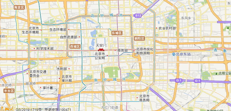
<p>本示例演示如何显示经纬度直投地图。</p>
</body>
</html>运行结果
-
加上缩放放大组件
<!DOCTYPE html>
<html>
<head>
<meta http-equiv="content-type" content="text/html; charset=utf-8"/>
<meta name="keywords" content="天地图"/>
<title>天地图-地图API-范例-添加缩放平移控件</title>
<script type="text/javascript" src="http://api.tianditu.gov.cn/api?v=4.0&tk=您的密钥"></script>
<style type="text/css">body,html{width:100%;height:100%;margin:0;font-family:"Microsoft YaHei"}#mapDiv{width:100%;height:400px}input,b,p{margin-left:5px;font-size:14px}</style>
<script>
var map, control;
var zoom = 12;
function onLoad() {
//初始化地图对象
map = new T.Map("mapDiv");
//设置显示地图的中心点和级别
map.centerAndZoom(new T.LngLat(116.40969, 39.89945), zoom);
//创建缩放平移控件对象
control = new T.Control.Zoom();
//添加缩放平移控件
map.addControl(control);
control.setPosition(T_ANCHOR_TOP_RIGHT);
}
</script>
</head>
<body onLoad="onLoad()">
<div id="mapDiv"></div>
</body>
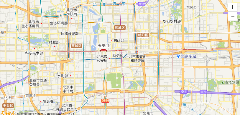
</html>效果:
-
添加自定义图片标注
<!DOCTYPE html>
<html>
<head>
<meta http-equiv="content-type" content="text/html; charset=utf-8"/>
<meta name="keywords" content="天地图"/>
<title>天地图-地图API-范例-自定义标注图片</title>
<script type="text/javascript" src="http://api.tianditu.gov.cn/api?v=4.0&tk=您的密钥"></script>
<style type="text/css">body,html{width:100%;height:100%;margin:0;font-family:"Microsoft YaHei"}#mapDiv{width:100%;height:400px}input,b,p{margin-left:5px;font-size:14px}</style>
<script>
var map;
var zoom = 12;
function onLoad() {
//初始化地图对象
map = new T.Map("mapDiv");
//设置显示地图的中心点和级别
map.centerAndZoom(new T.LngLat(116.40969, 39.89945), zoom);
//创建缩放平移控件对象
control = new T.Control.Zoom();
//添加缩放平移控件
map.addControl(control);
control.setPosition(T_ANCHOR_TOP_RIGHT);
//创建图片对象
var icon = new T.Icon({
iconUrl: "http://api.tianditu.gov.cn/img/map/markerA.png",
iconSize: new T.Point(19, 27),
iconAnchor: new T.Point(10, 25)
});
//向地图上添加自定义标注
var marker = new T.Marker(new T.LngLat(116.411794, 39.9068), {icon: icon});
map.addOverLay(marker);
}
</script>
</head>
<body onLoad="onLoad()">
<div id="mapDiv" ></div>
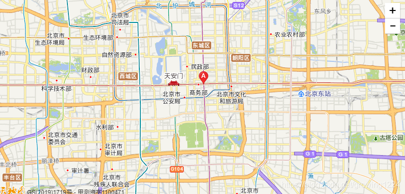
<p>本示例演示如何自定义标注图片。</p>
</body>
</html>- 运行结果
:
-
添加事件
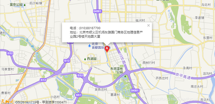
<!DOCTYPE html>
<html>
<head>
    <meta http-equiv="content-type" content="text/html; charset=utf-8"/>
    <meta name="keywords" content="天地图"/>
    <title>天地图-地图API-范例-信息窗口</title>
    <script type="text/javascript" src="http://api.tianditu.gov.cn/api?v=4.0&tk=您的密钥"></script>
    <style type="text/css">body,html{width:100%;height:100%;margin:0;font-family:"Microsoft YaHei"}#mapDiv{width:100%;height:400px}input,b,p{margin-left:5px;font-size:14px}</style>
    <script>
        var map;
        var zoom = 12;
        var center;
        var localsearch;
        var radius = 5000;
        var infoWin;
        function onLoad() {
        	center = new T.LngLat(116.63072 ,40.054952);
            //初始化地图对象
            map = new T.Map("mapDiv");
            //设置显示地图的中心点和级别
            map.centerAndZoom(center, zoom);
            createMaker();
        }

      function createMaker(){
        	var icon = new T.Icon({
                            iconUrl: "http://api.tianditu.gov.cn/img/map/markerA.png",
                            iconSize: new T.Point(19, 27),
                            iconAnchor: new T.Point(10, 25)
             });
      	    var marker = new T.Marker(center, {icon: icon});// 创建标注
       	    map.addOverLay(marker);
            var infoWin1 = new T.InfoWindow();
            var sContent =
                "<div style='margin:0px;'>" +
                "<div style='margin:10px 10px; '>" +
                "<div>电话 : (010)88187700 <br>地址:北京市顺义区机场东路国门商务区地理信息产业园2号楼天地图大厦" +
                "</div>" +
                "</div>";
            infoWin1.setContent(sContent);
            marker.addEventListener("click", function () {
            marker.openInfoWindow(infoWin1);
            });// 将标注添加到地图中
      }
      function clearAllMarkLayer(){
    		map.clearOverLays();
	  }
    </script>
</head>
<body onLoad="onLoad()">
<div id="mapDiv" ></div>
<p>本示例演示如何在地图上显示一个信息浮窗。</p>
<div id="resultDiv"></div>
</body>
</html>
效果:


 1076
1076

 被折叠的 条评论
为什么被折叠?
被折叠的 条评论
为什么被折叠?
 到【灌水乐园】发言


