


步骤
- 创建maven项目
- 修改pom.xml
- 写测试代码
- 下载.shp文件
- 运行代码
1.创建maven项目
自己打开idea创建一个空的maven项目即可,也可以用其它任何你喜欢的IDE。GeoTools需要Java11以上的版本,否则会在编译时报错,这个需要注意一下。
2.修改pom.xml
<project>

    <!--定义属性-->
    <properties>
        <maven.compiler.source>17</maven.compiler.source>
        <maven.compiler.target>17</maven.compiler.target>
        <project.build.sourceEncoding>UTF-8</project.build.sourceEncoding>
        <geotools.version>32-SNAPSHOT</geotools.version>
        <maven.deploy.skip>true</maven.deploy.skip>
    </properties>

    <!--添加依赖-->
    <dependencies>
        <dependency>
            <groupId>org.geotools</groupId>
            <artifactId>gt-shapefile</artifactId>
            <version>${geotools.version}</version>
        </dependency>
        <dependency>
            <groupId>org.geotools</groupId>
            <artifactId>gt-swing</artifactId>
            <version>${geotools.version}</version>
        </dependency>
    </dependencies>

    <!--增加外部仓库-->
    <repositories>
        <repository>
            <id>osgeo</id>
            <name>OSGeo Release Repository</name>
            <url>https://repo.osgeo.org/repository/release/</url>
            <snapshots>
                <enabled>false</enabled>
            </snapshots>
            <releases>
                <enabled>true</enabled>
            </releases>
        </repository>
        <repository>
            <id>osgeo-snapshot</id>
            <name>OSGeo Snapshot Repository</name>
            <url>https://repo.osgeo.org/repository/snapshot/</url>
            <snapshots>
                <enabled>true</enabled>
            </snapshots>
            <releases>
                <enabled>false</enabled>
            </releases>
        </repository>
    </repositories>
</project>
3.写测试代码
/*
 *    GeoTools Sample code and Tutorials by Open Source Geospatial Foundation, and others
 *    https://docs.geotools.org
 *
 *    To the extent possible under law, the author(s) have dedicated all copyright
 *    and related and neighboring rights to this software to the public domain worldwide.
 *    This software is distributed without any warranty.
 *
 *    You should have received a copy of the CC0 Public Domain Dedication along with this
 *    software. If not, see <http://creativecommons.org/publicdomain/zero/1.0/>.
 */
package org.example;

import org.geotools.api.data.FileDataStore;
import org.geotools.api.data.FileDataStoreFinder;
import org.geotools.api.data.SimpleFeatureSource;
import org.geotools.api.style.Style;
import org.geotools.map.FeatureLayer;
import org.geotools.map.Layer;
import org.geotools.map.MapContent;
import org.geotools.styling.SLD;
import org.geotools.swing.JMapFrame;
import org.geotools.swing.data.JFileDataStoreChooser;

import java.io.File;
import java.util.logging.Logger;

/**
 * Prompts the user for a shapefile and displays the contents on the screen in a map frame.
 *
 * <p>This is the GeoTools Quickstart application used in documentationa and tutorials. *
 */
public class Quickstart {

    private static final Logger LOGGER = org.geotools.util.logging.Logging.getLogger(Quickstart.class);

    /**
     * GeoTools Quickstart demo application. Prompts the user for a shapefile and displays its
     * contents on the screen in a map frame
     */
    public static void main(String[] args) throws Exception {
        // display a data store file chooser dialog for shapefiles
        LOGGER.info("Quickstart");
        LOGGER.config("Welcome Developers");
        LOGGER.info("java.util.logging.config.file=" + System.getProperty("java.util.logging.config.file"));
        File file = JFileDataStoreChooser.showOpenFile("shx", null);
        if (file == null) {
            return;
        }
        LOGGER.config("File selected " + file);

        FileDataStore store = FileDataStoreFinder.getDataStore(file);
        SimpleFeatureSource featureSource = store.getFeatureSource();

        // Create a map content and add our shapefile to it
        MapContent map = new MapContent();
        map.setTitle("Quickstart");

        Style style = SLD.createSimpleStyle(featureSource.getSchema());
        Layer layer = new FeatureLayer(featureSource, style);
        map.addLayer(layer);

        // Now display the map
        JMapFrame.showMap(map);
    }
}
4.下载.shp文件
下载地址:http://www.naturalearthdata.com/
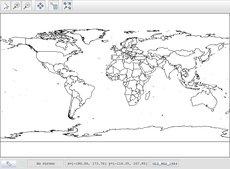
5.运行代码


 3523
3523


 被折叠的 条评论
为什么被折叠?
被折叠的 条评论
为什么被折叠?
 到【灌水乐园】发言


