


最新1990-2022年中国30m年水土流失空间分布数据集
数据介绍
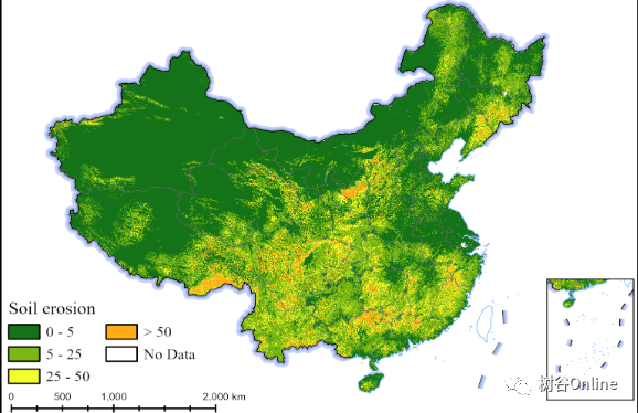
本数据集为1990-2022年中国腹地30m土壤水蚀数据(t/(hm 2a)),基于 Google Earth Engine 和修订后的通用土壤流失方程 (RUSLE) 构建。RUSLE公式包括五个因子:覆盖管理因子(C)、土壤侵蚀因子(K)、坡长和陡度因子(LS)、降雨侵蚀力因子(R)和支护实践因子(P)。将这五个因子相乘,即可得到土壤侵蚀模数。每个 zip 文件包含中国 31 个省份的土壤侵蚀数据(缺少 3 个省份的数据)。该数据集中的所有文件均为 TIFF 格式。每个省份根据其面积大小被分为多个区块。要使用此数据集,需要将省份的每个图块镶嵌在一起。该数据集不仅使公众能够更全面、深入地了解水土流失的严重危害,还为公众提供了区域性、精准化、为政府决策提供科学依据。
由于数据量较大,目前作者已经公布5省数据,分别是:安徽、湖南、湖北、江西、福建,数据容量共计9GB。

数据信息
数据容量:8.44GB
数据格式:TIFF
空间范围:安徽、湖南、湖北、江西、福建
空间分辨率:30M
数据作者
Jiaxin Feng;Haixu He;Jining Yan;Yi Wang;Zhongchang Sun;Jun Li
参考资源
Aiello, A., Adamo, M., and Canora, F.: Remote sensing and15 GIS to assess soil erosion with RUSLE3D and USPED at river basin scale in southern Italy, Catena, 131, 174–185, https://doi.org/10.1016/j.catena.2015.04.003, 2015.
Duan, X., Bai, Z., Rong, L., Li, Y., Ding, J., Tao, Y., Li, J., Li, J., and Wang, W.: Investigation method for re- 80 gional soil erosion based on the Chinese Soil Loss Equa- tion and high-resolution spatial data: Case study on the mountainous Yunnan Province, China, Catena, 184, 104 237, https://doi.org/10.1016/j.catena.2019.104237, 2020.
Panagos, P., Borrelli, P., Meusburger, K., Alewell, C., Lugato, E., and Montanarella, L.: Estimating the soil erosion cover- management factor at the European scale, Land use policy, 48, 38–50, https://doi.org/10.1016/j.landusepol.2015.05.021, 2015.
Renard, K. G.: Predicting soil erosion by water: a guide to conser- vation planning with the Revised Universal Soil Loss Equation (RUSLE), United States Government Printing, 1997.
Renard, K. G., Foster, G. R., Yoder, D. C., and Mccool, D. K.: RUSLE revisited: Status, questions, answers, and the future, Journal of Soil and Water Conservation, 49, 213–220, 1994.
Teng, H., Rossel, R. A. V., Shi, Z., Behrens, T., Chappell, M. A., and Bui, E. N.: Assimilating satellite imagery and visible- near infrared spectroscopy to model and map soil loss by wa- ter erosion in Australia, Environ. Model. Softw., 77, 156–167,30 https://doi.org/10.1016/j.envsoft.2015.11.024, 2016.
数据下载


 264
264

 被折叠的 条评论
为什么被折叠?
被折叠的 条评论
为什么被折叠?
 到【灌水乐园】发言


