


1、以local方式连接arcgis server 时需要设置ArcGis Identity,并且连接的用户要属于agsadmin或agsusers;而如果以internet方式连接不用设置identity,它是以Web Application Post Install时指定的用户进行连接,如ArcGISWebServices。
2、Arcgis Server中的Web resource
A、Use Asp.net 2.0 HTTP handler WebResource.axd
i)Resource ar embedded into assemblies
- javascript
- images
ii)Streamed to client at run time by default
B、Files provide alternative resources
i)<IISRoot>/aspnet_client
ii)Web application relative path
iii)Support file-based Web sites(Cassini)
注意:A是默认的方法,如果要启用B方法,需要将UseDefaultWebResources设置为false,并且WebResourceLocation要指定要一个正确的路径上。
3、Map控件的ImageBlendingMode属性介绍
i)Image blending:Web tier ——图片叠加发生在web server
- Images are created for each map resource
- Images are blended at web tier
- Browser receives a single image
- Individual resource cannot be refreshed
ii)image blending:Browser ——图片在浏览器端叠加
- Images are created for each map resource
- Browser receives individual images
- Images are blended on the client using css
- Individual resources may be refreshed
eg。
if(Map1.ImageBlendingMode==ImageBlendingMode.WebTier)
            {
                //对所有的地图图层刷新                Map1.Refresh();
            }
else if(Map1.ImageBlendingMode==ImageBlendingMode.Browser)
            {
                //只刷新Graphics Resource
                Map1.RefreshResource(selectResource.Name);
            }
4、MapTips控件在9.2中只能应用于点图层。
5、ZoomLevel控件只能应用于创建了缓存的服务,不然的话就算使用了,也显示不出来。
6、Graphics overview
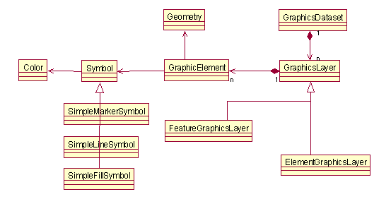
7、使用graphics layers的一般步骤
- Create a new graphics layers
- Add to graphics dataset
- Create new geometry
- Define symbols and rendering
- Create graphic elements
- Add to graphics layer
- Redraw graphics resource
8、ElementGraphicsLayer和FeatureGraphicsLayer的区别
ElementGraphicsLayer:
- 只能包含几何体和symbol等空间信息,不能包含属性信息。
- 可以包含任何的几何图形,混合存储
- 简单渲染
- 在selection,buffering,displaying a few features等简单的情况下使用
FeatureGraphicsLayer:
- 即有空间信息又有属性信息
- 只能存储某种单一几何图形
- 可以支持复杂渲染器
- 量大的时候使用
9、CallbackResults的eventArg说明
| eventArg | Description |
| "content" | Sets outerHTML of element |
| "innercontent" | Sets innerHTML of element |
| "image" | Sets src of image |
| "javascript" | Executes javascript(function) |
10、Task Runtime WorkFlow


 330
330

 被折叠的 条评论
为什么被折叠?
被折叠的 条评论
为什么被折叠?
 到【灌水乐园】发言


