


 本文介绍如何使用Python结合shp文件对地图进行特定区域的白化处理,通过shp2clip()函数实现对中国省份以外地区的屏蔽。文章详细讲解了如何分析shp文件并调整代码以适应不同格式的文件,提供了完整的代码示例,帮助读者理解并应用到自己的项目中。
网上的白化教程各式各样,我也是自己从零开始慢慢摸索,这也算是篇记录自己心路历程的整合吧,代码也是来源网上,在这只做一个使用解说的效果。
首先先看一下没有白化的样例代码和图:
from netCDF4 import Dataset as nc
import matplotlib.pyplot as plt
import cartopy.crs as ccrs

if __name__=='__main__':
    pth='air.2m.mon.mean.nc'
    f=nc(pth)
    t=f.variables['air'][:]
    lon=f.variables['lon'][:]
    lat=f.variables['lat'][:]
    t=t[0,0,:,:]
    t=t-273.15

    fig=plt.figure(figsize=(11.5,4.5))
    ax=fig.add_subplot(1,1,1,projection=ccrs.PlateCarree())
    h=ax.contourf(lon,lat,t,cmap='jet',transform=ccrs.PlateCarree())
    ax.coastlines()
    plt.colorbar(h,location='right')
    g=ax.gridlines(draw_labels=['left','bottom'])
    g.xlines=False
    g.ylines=False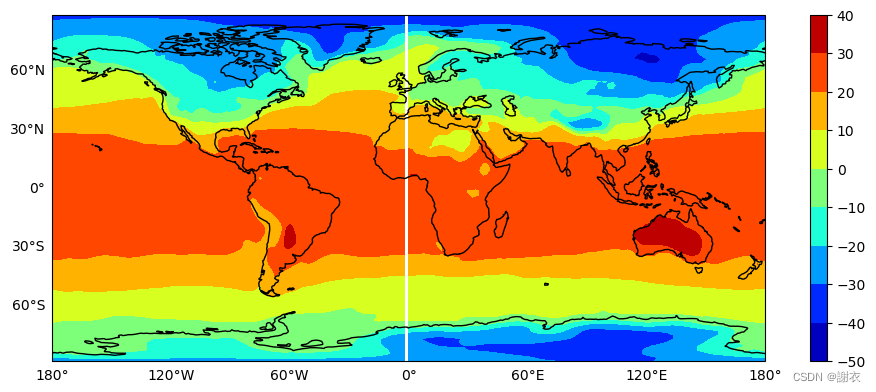
接下来我们开始利用shp2clip()函数对中国地区以外的白化,即屏蔽其他地区
先放出shp2clip()函数的代码,稍后说明怎么使用:
def shp2clip(originfig, ax, shpfile, regionlist):  #白化函数
    sf = shapefile.Reader(s
最低0.47元/天 解锁文章


 被折叠的 条评论
为什么被折叠?
被折叠的 条评论
为什么被折叠?
 到【灌水乐园】发言


