


生成gamma格式DEM
例如:原图像为UTM投影,ENVI格式下的头文件信息为:
http://blog.sina.com.cn/s/blog_a7ebc03b0102xary.html
ENVI description = { Registration Result. Method: 1st degree Polynomial w/ nearest neighbor [Wed Dec 20 23:59:19 1995] } samples = 709 lines = 946 bands = 7 header offset = 0 file type = ENVI Standard data type = 1 interleave = bsq sensor type = Landsat TM byte order = 0 map info = {UTM, 1, 1, 295380.000, 4763640.000, 30.000000, 30.000000, 13, North} z plot range = {0.00, 255.00} z plot titles = {Wavelength, Reflectance} pixel size = {30.000000, 30.000000} default stretch = 5.0% linear band names = { Warp (Band 1:rs_tm.img), Warp (Band 2:rs_tm.img), Warp (Band 3:rs_tm.img), Warp (Band 4:rs_tm.img), Warp (Band 5:rs_tm.img), Warp (Band 6:rs_tm.img), Warp (Band 7:rs_tm.img)} wavelength = { 0.485000, 0.560000, 0.660000, 0.830000, 1.650000, 11.400000, 2.215000} fwhm = { 0.070000, 0.080000, 0.060000, 0.140000, 0.200000, 2.100000, 0.270000}
其中map info信息为:
map info = {UTM, 1, 1, 295380.000, 4763640.000, 30.000000, 30.000000, 13, North}
解释:
map info - lists geographic coordinates information in the order of projection name (UTM), reference pixel x location in file coordinates, pixel y, pixel easting, pixel northing, x pixel size, y pixel size, Projection Zone, North or South for UTM only.
UTM:投影名称
1:参考像素x在文件坐标的位置
1:参考像素y在文件坐标位置
295380.000:像素以东
4763640.000:像素以北
30.000000:x像素间隔
30.000000:y像素间隔
13:投影带号
North:北部
在更改生成的gamma格式的dem后,需要对生成的dem的参数par文件更改头文件:
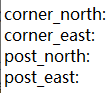
corner_north为像素以北的值
corner_east像素以东的值
post_north像素间隔
post_east像素间隔


 2万+
2万+

 被折叠的 条评论
为什么被折叠?
被折叠的 条评论
为什么被折叠?
 到【灌水乐园】发言


