


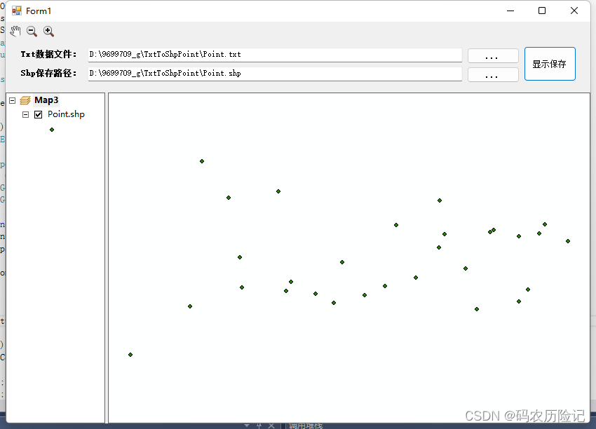
操作步骤
1.选择txt文件
2.创建shp保存路径
3.保存
视图:
代码
 public partial class Form1 : Form
    {
        public Form1()
        {
            ESRI.ArcGIS.RuntimeManager.Bind(ESRI.ArcGIS.ProductCode.EngineOrDesktop);
            InitializeComponent();
        }
        //选择Txt文件
        private void btn_TxtPath_Click(object sender, EventArgs e)
        {
            OpenFileDialog xjTxtOpenFileDialog = new OpenFileDialog();
            xjTxtOpenFileDialog.Multiselect = false;
            xjTxtOpenFileDialog.Title = "打开txt坐标文件";
            xjTxtOpenFileDialog.Filter = "txt坐标文件(*.txt)|*.txt";
            if (xjTxtOpenFileDialog.ShowDialog() == DialogResult.OK)
            {
                txt_TxtPath.Text = xjTxtOpenFileDialog.FileName;
            }
        }
        //Shp矢量点保存路径
        private void btn_ShpPath_Click(object sender, EventArgs e)
        {
            SaveFileDialog xjShpSaveFileDialog = new SaveFileDialog();
            xjShpSaveFileDialog.Filter = "Shape文件(*.shp)|*.shp";
            if (File.Exists(txt_TxtPath.Text))
            {
                xjShpSaveFileDialog.FileName = System.IO.Path.GetFileNameWithoutExtension(txt_TxtPath.Text);
            }
            if (xjShpSaveFileDialog.ShowDialog() == DialogResult.OK)
            {
                txt_ShpPath.Text = xjShpSaveFileDialog.FileName;
            }
        }

        //显示保存
        //检查数据和路径
        private bool Check()
        {
            if (txt_TxtPath.Text == "" || !File.Exists(txt_TxtPath.Text))
            {
                MessageBox.Show("数据无效哇,重选", "提示", MessageBoxButtons.OK);
                return false;
            }
            if (txt_ShpPath.Text == "" || System.IO.Path.GetExtension(txt_ShpPath.Text).ToLower() != ".shp")
            {
                MessageBox.Show("Shp矢量点保存路径无效哇,重选", "提示", MessageBoxButtons.OK);
                return false;
            }
            return true;
        }
        //结构体
        struct Point
        {
            public string Name;
            public double X;
            public double Y;
        }
        List<string> xjColumn = new List<string>();
        //获取点数据
        private List<Point> GetPoint(string surveyDataFullName)
        {
            try
            {
                List<Point> xjList = new List<Point>();
                char[] xjchar = new char[] { ',', ' ', '\t' };   //常用的分隔符为逗号、空格、制位符
                //读取
                FileStream xjFileStream = new FileStream(surveyDataFullName, FileMode.Open);
                StreamReader xjStreamReader = new StreamReader(xjFileStream, Encoding.Default);
                string xjstringLine = xjStreamReader.ReadLine();
                if (xjstringLine != null)
                {
                    string[] xjstrArray = xjstringLine.Split(xjchar);
                    if (xjstrArray.Length > 0)
                    {
                        for (int i = 0; i < xjstrArray.Length; i++)
                        {
                            xjColumn.Add(xjstrArray[i]);
                        }
                    }

                    while ((xjstringLine = xjStreamReader.ReadLine()) != null)
                    {
                        //点信息的读取
                        xjstrArray = xjstringLine.Split(xjchar);
                        Point xjPoint = new Point();
                        xjPoint.Name = xjstrArray[0].Trim();
                        xjPoint.X = Convert.ToDouble(xjstrArray[1]);
                        xjPoint.Y = Convert.ToDouble(xjstrArray[2]);

                        xjList.Add(xjPoint);
                    }
                }
                else
                {
                    return null;
                }
                xjStreamReader.Close();
                return xjList;
            }
            catch (Exception ex)
            {
                MessageBox.Show(ex.Message);
                return null;
            }
        }
        //创建Shp矢量图层
        private IFeatureLayer CreateShpFromPoints(List<Point> xjPointList, string xjFilePath)
        {
            int index = xjFilePath.LastIndexOf('\\');
            string xjFolder = xjFilePath.Substring(0, index);
            string xjShapeName = xjFilePath.Substring(index + 1);
            IWorkspaceFactory xjWsF = new ShapefileWorkspaceFactoryClass();
            IFeatureWorkspace xjFWs = (IFeatureWorkspace)xjWsF.OpenFromFile(xjFolder, 0);
            //定义一个字段集
            IFields xjFields = new FieldsClass();
            IFieldsEdit xjFieldsEdit;
            xjFieldsEdit = (IFieldsEdit)xjFields;
            //定义一个字段
            IField xjField = new FieldClass();
            IFieldEdit xjFieldEdit = (IFieldEdit)xjField;
            xjFieldEdit.Name_2 = "Shape";   //字段的名字
            xjFieldEdit.Type_2 = esriFieldType.esriFieldTypeGeometry;   //字段的类型

            IGeometryDef xjGeometryDef = new GeometryDefClass();
            IGeometryDefEdit xjGDefEdit = (IGeometryDefEdit)xjGeometryDef;
            xjGDefEdit.GeometryType_2 = esriGeometryType.esriGeometryPoint;  //几何的类型
            //定义坐标系
            ISpatialReferenceFactory pSRF = new SpatialReferenceEnvironmentClass();
            ISpatialReference pSpatialReference = pSRF.CreateGeographicCoordinateSystem((int)esriSRGeoCSType.esriSRGeoCS_Beijing1954);
            xjGDefEdit.SpatialReference_2 = pSpatialReference;  //设置几何的坐标系

            xjFieldEdit.GeometryDef_2 = xjGeometryDef;
            xjFieldsEdit.AddField(xjField);   //添加字段

            IFeatureClass xjFeatureClass;
            xjFeatureClass = xjFWs.CreateFeatureClass(xjShapeName, xjFields, null, null, esriFeatureType.esriFTSimple, "Shape", "");

            IPoint xjPoint = new PointClass();
            for (int j = 0; j < xjPointList.Count; j++)
            {
                xjPoint.X = xjPointList[j].X;
                xjPoint.Y = xjPointList[j].Y;
                //创建要素
                IFeature xjFeature = xjFeatureClass.CreateFeature();
                //设置要素的坐标
                xjFeature.Shape = xjPoint;
                xjFeature.Store();
            }

            IFeatureLayer xjFeatureLayer = new FeatureLayerClass();
            xjFeatureLayer.Name = xjShapeName;
            xjFeatureLayer.FeatureClass = xjFeatureClass;
            return xjFeatureLayer;
        }
        //单击显示保存
        private void btn_ShowSave_Click(object sender, EventArgs e)
        {
            if (Check())
            {
                List<Point> xjPointList = GetPoint(txt_TxtPath.Text);
                if (xjPointList == null)
                {
                    MessageBox.Show("选择文件是空的,转毛线啊");
                }
                else
                {
                    IFeatureLayer pFeatureLayer = CreateShpFromPoints(xjPointList, txt_ShpPath.Text);
                    ShpMapControl.Map.AddLayer(pFeatureLayer);
                }
            }
        }

        private void axLicenseControl1_Enter(object sender, EventArgs e)
        {

        }
    }
代码下载链接:https://pan.baidu.com/s/1vYDFcH29fLd3mcWcwOGV6Q
提取码:j3dg
txt坐标数据转内存图层线
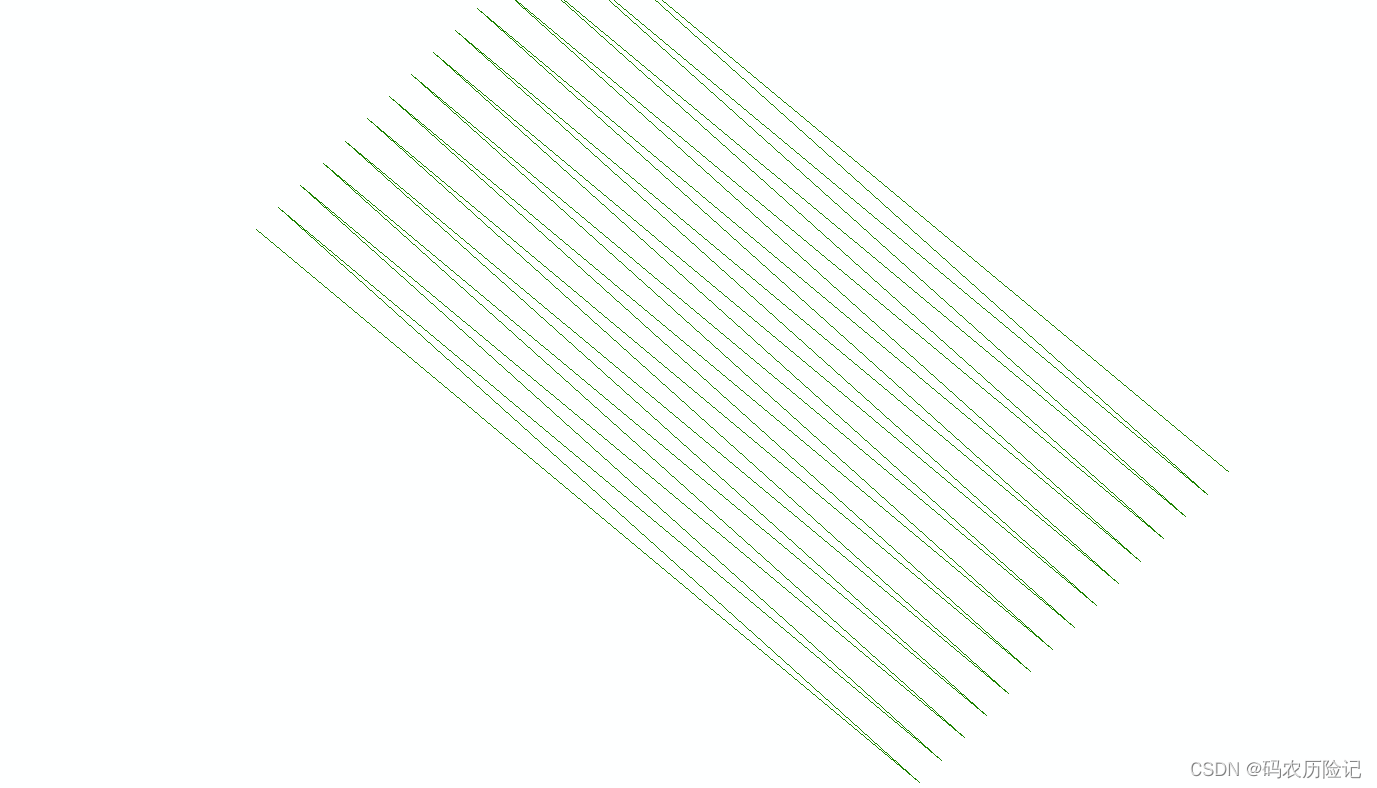
1.创建内存图层
2.添加线要素
代码
1.在内存中创建图层
 /// <summary>
        /// 在内存中创建图层
        /// </summary>
        /// <param name="DataSetName">数据集名称</param>
        /// <param name="AliaseName">别名</param>
        /// <param name="SpatialRef">空间参考</param>
        /// <param name="GeometryType">几何类型</param>
        /// <param name="PropertyFields">属性字段集合</param>
        /// <returns>IfeatureLayer</returns>
        public static IFeatureLayer CreateFeatureLayerInmemeory(string DataSetName, string AliaseName, ISpatialReference SpatialRef, esriGeometryType GeometryType, IFields PropertyFields)
        {
            IWorkspaceFactory workspaceFactory = new InMemoryWorkspaceFactoryClass();
            ESRI.ArcGIS.Geodatabase.IWorkspaceName workspaceName = workspaceFactory.Create("", "MyWorkspace", null, 0);
            ESRI.ArcGIS.esriSystem.IName name = (IName)workspaceName;
            ESRI.ArcGIS.Geodatabase.IWorkspace inmemWor = (IWorkspace)name.Open();

            IField oField = new FieldClass();
            IFields oFields = new FieldsClass();
            IFieldsEdit oFieldsEdit = null;
            IFieldEdit oFieldEdit = null;
            IFeatureClass oFeatureClass = null;
            IFeatureLayer oFeatureLayer = null;

            try
            {
                //创建字段集
                oFieldsEdit = oFields as IFieldsEdit;
                //创建一个字段
                oFieldEdit = oField as IFieldEdit;
                for (int i = 0; i < PropertyFields.FieldCount; i++)
                {
                    //添加自定义字段
                    oFieldsEdit.AddField(PropertyFields.get_Field(i));
                }
                //定义一个几何字段
                IGeometryDef geometryDef = new GeometryDefClass();
                IGeometryDefEdit geometryDefEdit = (IGeometryDefEdit)geometryDef;
                geometryDefEdit.AvgNumPoints_2 = 5;
                geometryDefEdit.GeometryType_2 = GeometryType;
                geometryDefEdit.GridCount_2 = 1;
                geometryDefEdit.HasM_2 = false;
                geometryDefEdit.HasZ_2 = false;
                geometryDefEdit.SpatialReference_2 = SpatialRef;  //几何字段的参考系
                geometryDefEdit.SpatialReference_2 = new UnknownCoordinateSystemClass();//没有这一句就报错,说尝试读取或写入受保护的内存。
                geometryDefEdit.SpatialReference.SetDomain(-200, 200, -200, 200);//没有这句就抛异常来自HRESULT:0x8004120E。

                //创建一个字段,并且添加到字段集对象中去
                oFieldEdit.Name_2 = "SHAPE";
                oFieldEdit.Type_2 = esriFieldType.esriFieldTypeGeometry;
                oFieldEdit.GeometryDef_2 = geometryDef;
                oFieldEdit.IsNullable_2 = true;
                oFieldEdit.Required_2 = true;
                oFieldsEdit.AddField(oField);

                oFeatureClass = (inmemWor as IFeatureWorkspace).CreateFeatureClass(DataSetName, oFields, null, null, esriFeatureType.esriFTSimple, "SHAPE", "");
                (oFeatureClass as IDataset).BrowseName = DataSetName;

                oFeatureLayer = new FeatureLayerClass();
                oFeatureLayer.Name = AliaseName;
                oFeatureLayer.FeatureClass = oFeatureClass;
            }
            catch
            {
            }
            return oFeatureLayer;
        }
2.调用内存图层的代码
IFeatureLayer pFeatureLayer = new FeatureLayerClass();
            IFieldsEdit curFileds = new FieldsClass();
            IFieldEdit curField = new FieldClass();
            curField = new FieldClass();
            curField.Name_2 = "名称";
            curField.Type_2 = esriFieldType.esriFieldTypeString;
            curFileds.AddField(curField);

            curField = new FieldClass();
            curField.Name_2 = "经度";
            curField.Type_2 = esriFieldType.esriFieldTypeDouble;
            curFileds.AddField(curField);

            curField = new FieldClass();
            curField.Name_2 = "纬度";
            curField.Type_2 = esriFieldType.esriFieldTypeDouble;
            curFileds.AddField(curField);
            //定义坐标系
            ISpatialReferenceFactory pSRF = new SpatialReferenceEnvironmentClass();
            ISpatialReference pSpatialReference = pSRF.CreateGeographicCoordinateSystem((int)esriSRGeoCSType.esriSRGeoCS_Beijing1954);
            pFeatureLayer = CreateFeatureLayerInmemeory("Position", "采集点", new UnknownCoordinateSystemClass(), esriGeometryType.esriGeometryPolyline, curFileds as IFields);
            mainMapControl.AddLayer(pFeatureLayer as ILayer);

            IFeatureCursor FeatureCursor;
            IFeature pFeature;
            IFeatureClass pFeatureClass = pFeatureLayer.FeatureClass;

            IPolyline linecollect = new PolylineClass();

            for (int j = 0; j < 15; j++)
                {

                   IPoint xjPoint = new PointClass();
                    xjPoint.X = -97 + j * 2;
                    xjPoint.Y = 85 + j * 2;
                    IPoint yjPoint = new PointClass();
                    yjPoint.X = -37 + j * 2;
                    yjPoint.Y = 35 + j * 2;

                    (linecollect as IPointCollection).AddPoint(xjPoint);
                    (linecollect as IPointCollection).AddPoint(yjPoint);
                    pFeature = pFeatureClass.CreateFeature();
                    pFeature.Shape = linecollect;
                    pFeature.Store();
                }
 mainMapControl.ActiveView.PartialRefresh(esriViewDrawPhase.esriViewGeography, pFeatureLayer, null);
            mainMapControl.ActiveView.ScreenDisplay.UpdateWindow();


 4451
4451


 被折叠的 条评论
为什么被折叠?
被折叠的 条评论
为什么被折叠?
 到【灌水乐园】发言


