


目录
注意:ol版本要用5.3.3,保证new GeoJson正常使用。6.1.1中不能用new GeoJSON()
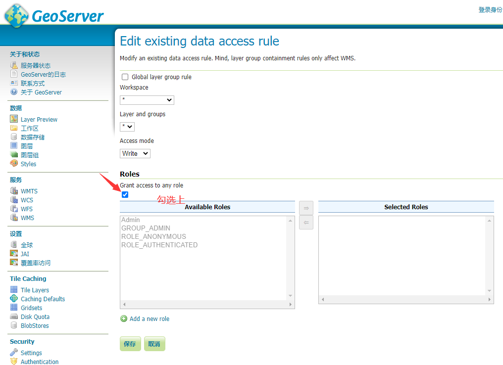
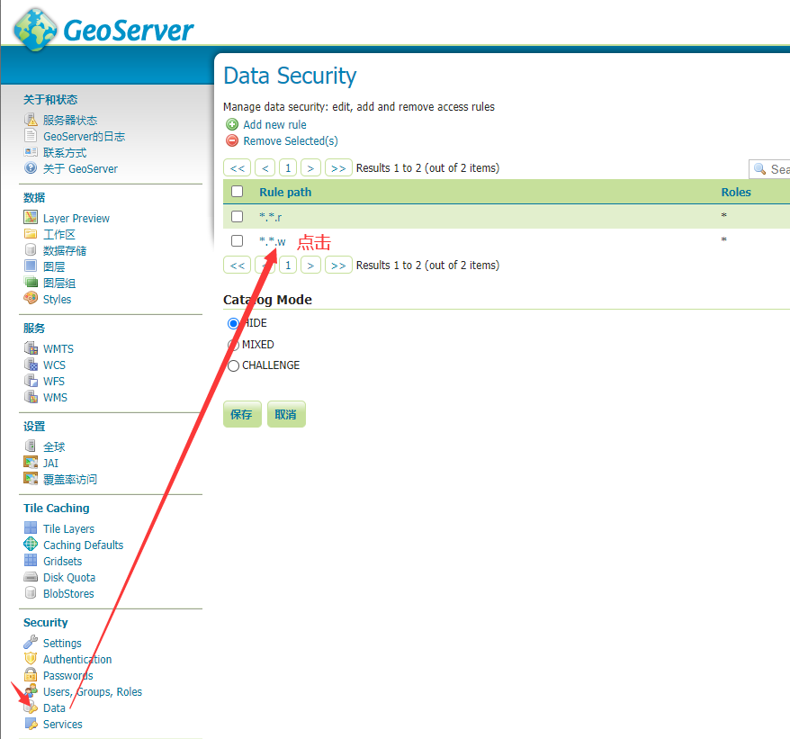
由于要修改矢量数据,涉及到权限问题,默认是不允许修改的,所以需要更改权限,操作如下:
查询数据
查询链接:
方式1:


<template>
  <div id="map" style="width: 100vw; height: 100vh"></div>
</template>

<script>
import "ol/ol.css";
import { Map, View, Feature } from "ol";
import { TileWMS, OSM, Vector as VectorSource } from "ol/source";
import { Vector as VectorLayer, Tile as TileLayer } from "ol/layer";

import GeoJSON from "ol/format/GeoJSON";
import { Point, LineString, Polygon } from "ol/geom";

export default {
  components: {},
  data() {
    return {
      map: {},
      vectorlayer: {},
    };
  },
  created() {},
  mounted() {
    this.initMap();
  },
  computed: {},
  methods: {
    initMap() {
      this.map = new Map({
        target: "map",

        layers: [
          new TileLayer({
            source: new OSM(),
          }),
          new VectorLayer({
            source: new VectorSource({
              //以下两个都可以,第一个是1.0.0版本,第二个是2.0.0版本
              url: "http://120.76.197.111:8090/geoserver/csdn_data/ows?service=WFS&version=1.0.0&request=GetFeature&typeName=csdn_data%3Asichuan&maxFeatures=50&outputFormat=application%2Fjson",
              // url: "http://120.76.197.111:8090/geoserver/csdn_data/ows?service=WFS&version=2.0.0&request=GetFeature&typeName=csdn_data%3Asichuan&count=50&outputFormat=application%2Fjson",

              format: new GeoJSON(),
            }),
          }),
        ],
        view: new View({
          projection: "EPSG:4326",
          center: [104, 30.3],
          zoom: 8,
        }),
      });
    },
  },
};
</script>
方式2:通过writeGetFeature

<template>
  <div id="map" style="width: 100vw; height: 100vh"></div>
</template>

<script>
import "ol/ol.css";
import { Map, View, Feature } from "ol";
import { TileWMS, OSM, Vector as VectorSource } from "ol/source";
import { Vector as VectorLayer, Tile as TileLayer } from "ol/layer";

import { GeoJSON, WFS, filter } from "ol/format";
import { Point, LineString, Polygon } from "ol/geom";

import Select from "ol/interaction/Select";
import { altKeyOnly, click, pointerMove } from "ol/events/condition";

export default {
  components: {},
  data() {
    return {
      map: {},
      vectorlayer: {},
    };
  },
  created() {},
  mounted() {
    this.initMap();
    this.addLayer();
  },
  computed: {},
  methods: {
    initMap() {
      this.map = new Map({
        target: "map",

        layers: [
          new TileLayer({
            source: new OSM(),
          }),
        ],
        view: new View({
          projection: "EPSG:4326",
          center: [104, 30.3],
          zoom: 7,
        }),
      });
    },
    async addLayer() {
      // 发送请求
      let json = await fetch("http://120.76.197.111:8090/geoserver/wfs", {
        method: "post",
        body: new XMLSerializer().serializeToString(
          new WFS().writeGetFeature({
            srsName: "EPSG:4326", //坐标系
            featureNS: "www.csdn_data.com", // 注意这个值必须为创建工作区时的命名空间URI
            featurePrefix: "csdn_data", //工作区的命名
            featureTypes: ["sichuan"], //所要访问的图层
            maxFeatures: 5000,
            outputFormat: "application/json",
          })
        ),
      }).then((response) => {
        return response.json();
      });

      let features = new GeoJSON().readFeatures(json);
      this.vectorlayer = new VectorLayer({
        source: new VectorSource(),
      });
      this.vectorlayer.getSource().addFeatures(features);
      this.map.addLayer(this.vectorlayer);
    },
  },
};
</script> 
新增数据
目前,只能对面进行新增和编辑,不能对点和线进行新增和编辑!
ol.format.wfs的writeTransaction方法,接受4个参数,前三个参数依次分别是要插入、更新、删除操作对应的Feature对象,以数组的形式。第4个参数是一个对象,里面定义了geoserver服务的相关信息。可以在一个Transaction操作中同时执行插入、更新、和删除操作。
<template>
  <div>
    <div style="position: fixed; top: 200px; left: 200px; z-index: 90000">
      <el-button @click="startDraw()">开始绘制</el-button>
      <el-button @click="saveDraw(featureDraw)">保存绘制</el-button>
    </div>

    <div id="map" style="width: 100vw; height: 100vh"></div>
  </div>
</template>

<script>
import "ol/ol.css";
import { Map, View, Feature } from "ol";
import { TileWMS, OSM, Vector as VectorSource } from "ol/source";
import { Vector as VectorLayer, Tile as TileLayer } from "ol/layer";

import { GeoJSON, WFS, filter } from "ol/format";
import { Point, LineString, Polygon, MultiPolygon } from "ol/geom";

import { Select, Draw, Modify } from "ol/interaction";
import { altKeyOnly, click, pointerMove } from "ol/events/condition";
 最低0.47元/天 解锁文章


 1477
1477


 被折叠的 条评论
为什么被折叠?
被折叠的 条评论
为什么被折叠?
 到【灌水乐园】发言


