


请关注我的WX_GZH:小Rser
 https://mp.weixin.qq.com/s?__biz=MzkyNjMzNTQ2Mw==&mid=2247483917&idx=1&sn=4704d36f575dc573047862cd847c11ff&chksm=c239aa85f54e23933f7386bc032d2777b9c49dd4f00220f6bd2d52be2f67ca8246cf893e9629&token=2086761678&lang=zh_CN#rd
Landsat Collection 1数据集
Level-1
Landsat Collection 1包含1972-2021年的1级数据产品,由 Landsat8(OLI)/(TIRS)、Landsat7(ETM+)、Landsat4-5 (TM)和Landsat1-5(MSS)传感器获取。Landsat Collection 1 Level-1数据以有符号16位整型格式作为数字(DN)提供。Landsat Collection 1 Level-1数据产品按以下方式分发:gzip压缩的tar文件(*.tar.gz)中包含中每个光谱波段和质量评估(QA)波段文件,图像文件格式为GeoTIFF,以及包含相关元数据、太阳和传感器角度等信息的txt文件。Landsat Collection 1已于2021年12月31日停止,在2022年12月31日之前仍可供搜索和下载。
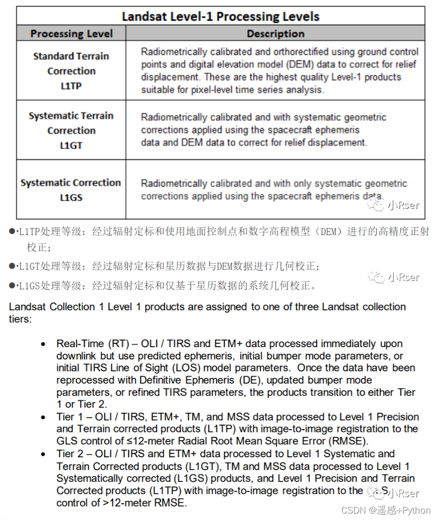
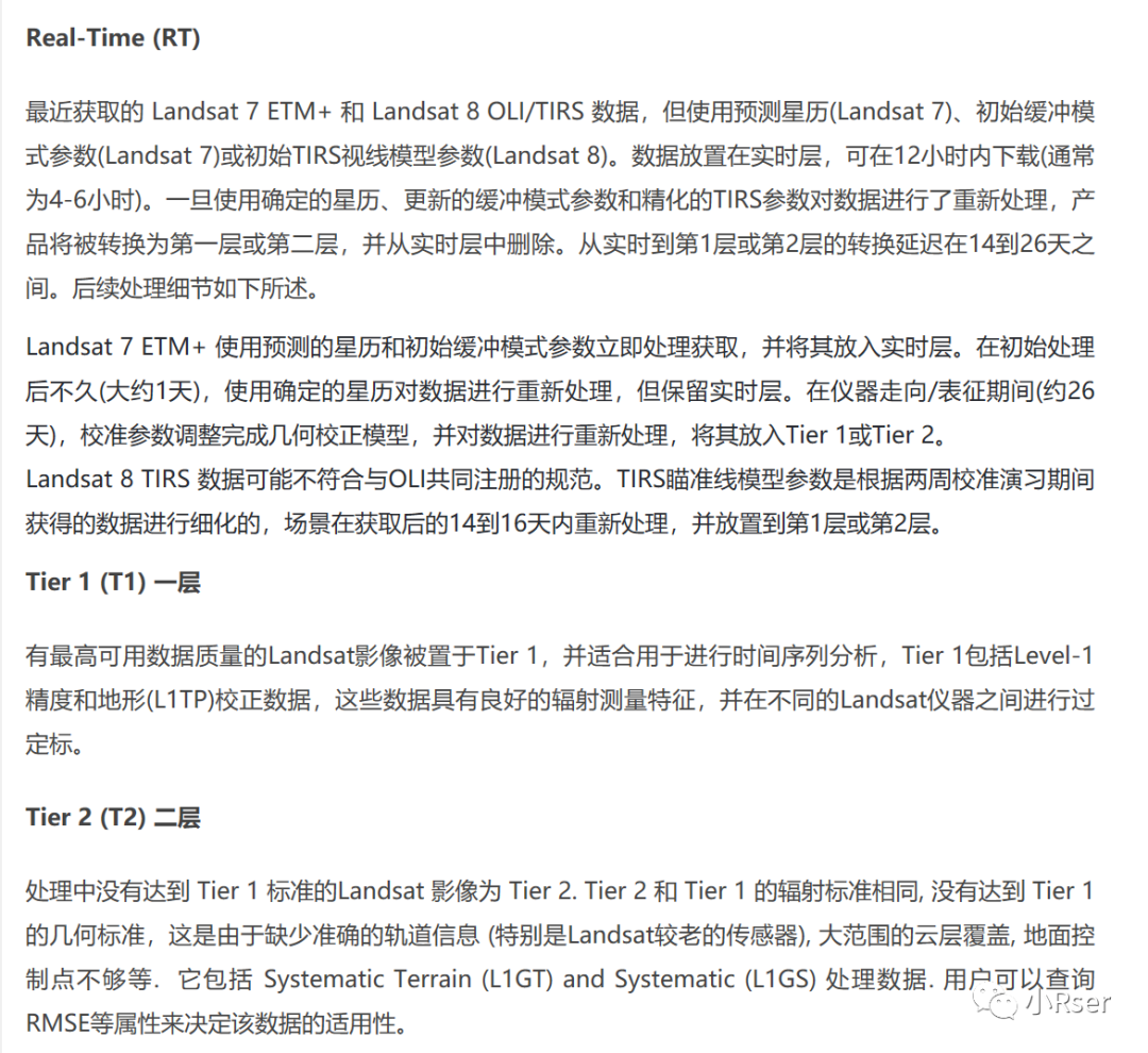
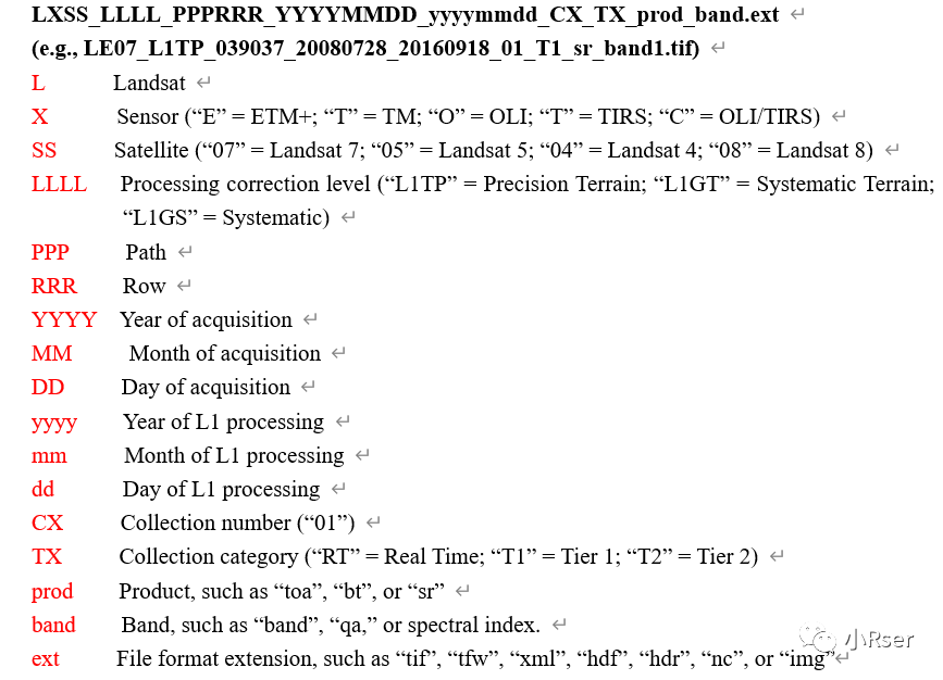
Landsat Collection 1 Level-1产品命名规则约定如下:
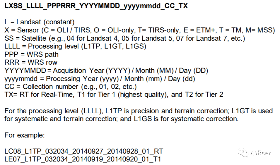
相关参数说明:
相关链接:
https://www.usgs.gov/media/files/landsat-collection-1-level-1-product-definition
https://www.usgs.gov/landsat-missions/landsat-collection-1-level-1-quality-assessment-band
https://www.usgs.gov/landsat-missions/landsat-collection-1
Level-2
Landsat Collection 1 Level-2包含以下数据数据产品:
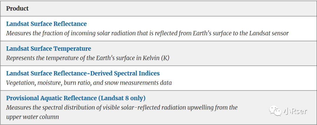
Landsat Surface Reflectance
Landsat Collection 1 Level-2的Landsat Surface Reflectance时间范围1982年7月-至今,包含Landsat4-5(TM)、Landsat7(ETM+)、Landsat8(OLI). Lansat8 Surface Reflectance称为LaSRC , Lansat4-5-7 Surface Reflectance称为LEDAPS. Landsat C1 SR产品以gzip文件(.tar.gz)提供。
Landsat Surface Reflectance产品命名规则约定如下:
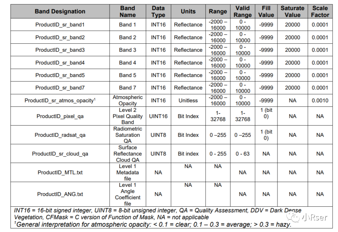
Landsat8的Landsat Surface Reflectance文件组成

Landsat4-5-7的Landsat Surface Reflectance文件组成
相关链接:
https://www.usgs.gov/media/files/landsat-4-7-collection-1-surface-reflectance-code-ledaps-product-guide
https://www.usgs.gov/media/files/landsat-8-collection-1-land-surface-reflectance-code-product-guide
https://www.usgs.gov/landsat-missions/landsat-collection-1-surface-reflectance
Landsat Surface Temperature
Landsat Collection 1 Level-2的Landsat Surface Temperature时间范围1982年7月-至今,包含Landsat4-5、Landsat7、Landsat8. Landsat C1 LST产品以gzip文件(.tar.gz)提供。
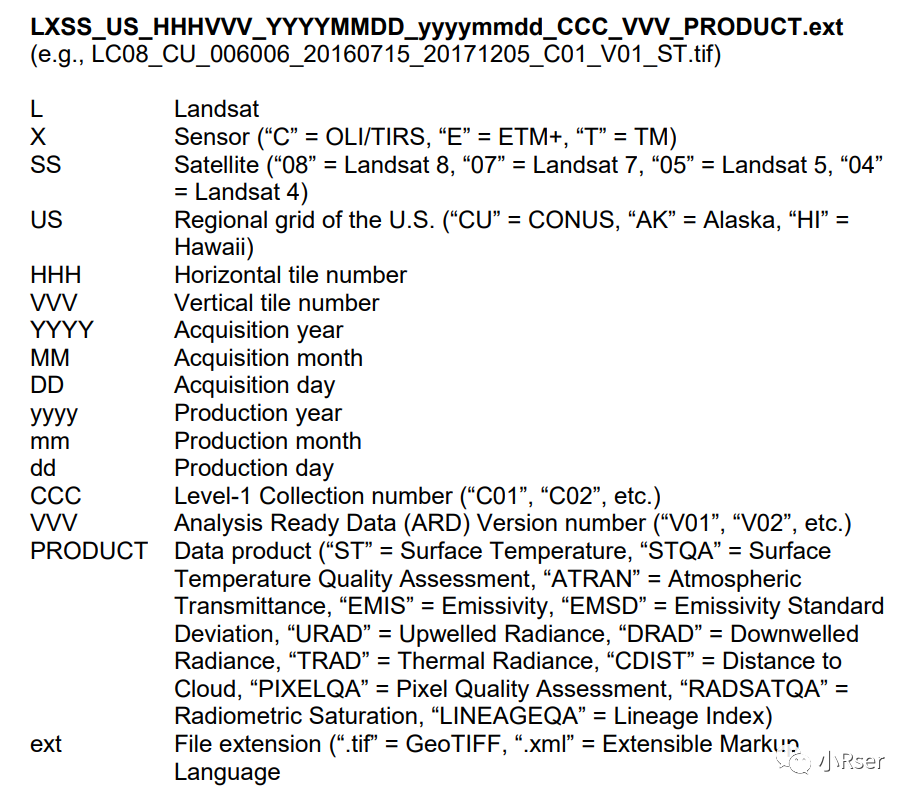
Landsat Surface Temperature产品命名规则约定如下:
文件组成
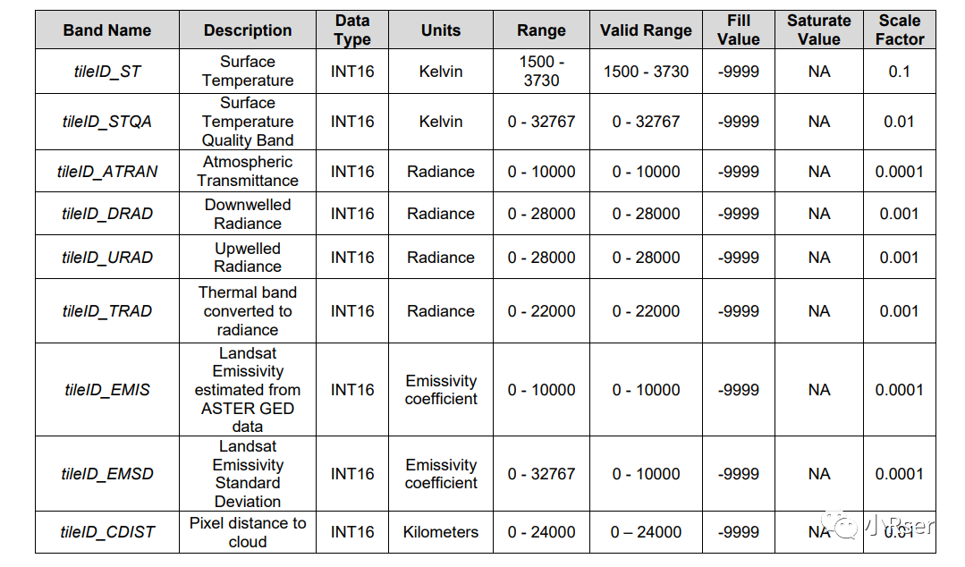
相关链接:
https://www.usgs.gov/landsat-missions/landsat-provisional-surface-temperature
https://www.usgs.gov/media/files/landsat-provisional-surface-temperature-product-guide
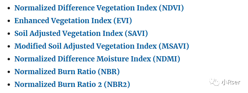
Landsat Surface Reflectance-derived Spectral Indices
地表反射率反演的指数。

相关链接:
https://www.usgs.gov/landsat-missions/landsat-surface-reflectance-derived-spectral-indices
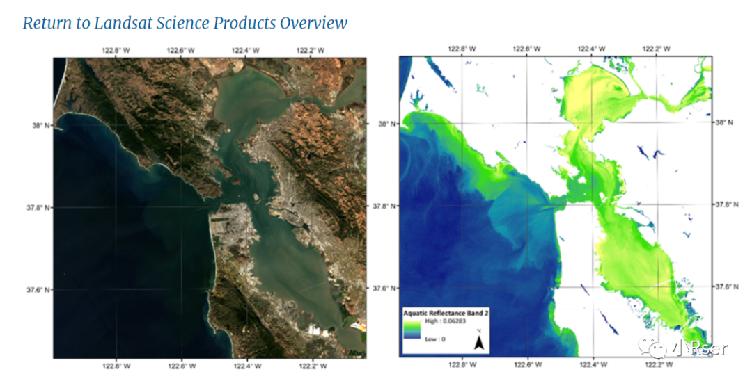
Provisional Aquatic Reflectance (Landsat 8 only)
Landsat 8 Provisional Aquatic Reflectance用于海洋遥感中。
相关链接:
https://www.usgs.gov/landsat-missions/landsat-provisional-aquatic-reflectance
https://www.usgs.gov/media/files/landsat-provisional-aquatic-reflectance-product-guide
Level-3
Landsat Collection 1 Level-3包含以下数据数据产品:
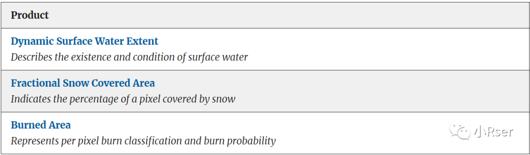

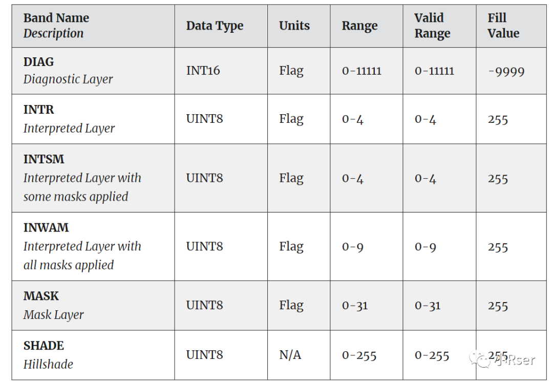
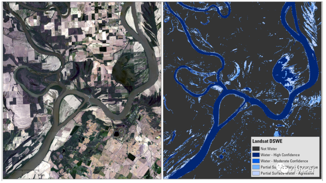
Dynamic Surface Water Extent
Landsat Collection 1 Level-3的Dynamic Surface Water Extent时间范围1982年12月-2021年12月31日,包含Landsat4-5(TM)、Landsat7(ETM+)、Landsat8(OLI). Landsat C1 DSWE产品包括六个GeoTiff栅格图层和一个与地表水的存在和状况相关的.xml元数据文件。
相关链接:
https://www.usgs.gov/landsat-missions/landsat-collection-1-level-3-dynamic-surface-water-extent-science-product
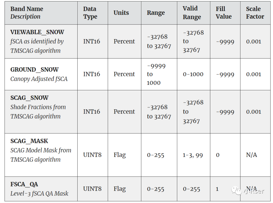
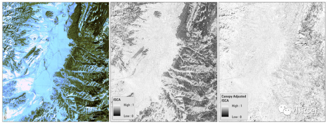
Fractional Snow Covered Area
Landsat Collection 1 Level-3的Fractional Snow Covered Area时间范围1984年3月-2021年12月31日,包含Landsat4-5(TM)、Landsat7(ETM+)、Landsat8(OLI).
Landsat C1 FSCA产品包含基于每个像素积雪分数、质量评估和产品元数据文件。注意:SNOW波段的可扩展标记语言 (.xml) 文件中的比例因子不正确。比例因子应为0.001,而不是 .xml 文件中显示的当前0.0001。未缩放时这些分数的有效范围应在0.0和1.0之间。
相关链接:
https://www.usgs.gov/landsat-missions/landsat-collection-1-level-3-fractional-snow-covered-area-science-product
Burned Area
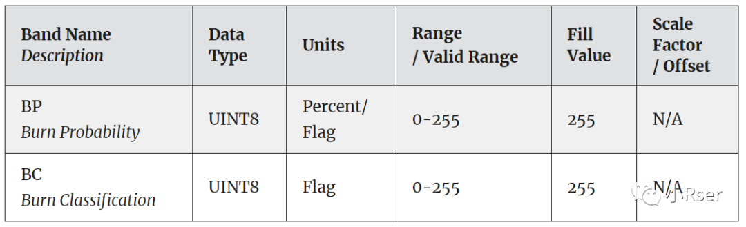
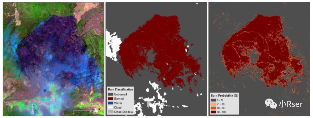
Landsat Collection 1 Level-3的Burned Area时间范围1984年3月-2021年12月31日,包含Landsat4-5(TM)、Landsat7(ETM+)、Landsat8(OLI).Landsat C1 BA产品包括两个栅格数据文件,分别代表燃烧分类和燃烧概率。
相关链接:
https://www.usgs.gov/landsat-missions/landsat-collection-1-level-3-burned-area-science-product
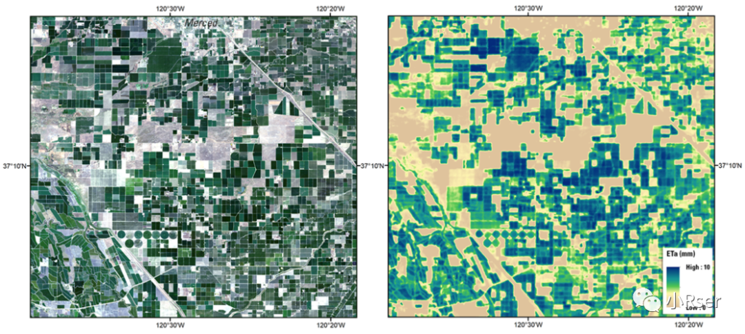
Provisional Actual Evapotranspiration
Landsat Collection 1 Level-3的ETa包含Landsat4-5(TM)、Landsat7(ETM+)、Landsat8(OLI).Landsat C1 ETa产品包括ET fraction (ETf)、Actual Evapotranspiration (ETa)、Percent Uncertainty、ET Uncertainty (ETUN)、ET Quality Assessment (ETQA)、Pixel Quality Assessment (pixel_qa)和XMLMetadata。
相关链接:
https://www.usgs.gov/landsat-missions/landsat-provisional-actual-evapotranspiration
Landsat Collection 2数据集
Level-1
Landsat Collection 2 Level-1是Landsat Collection 1 Level-1数据的改进版本,文件规格等基本一致,主要有以下改进:
1)Data Processing Improvements
2)Data Processing Improvements
3)Radiometric Accuracy Improvements
相关链接:
https://www.usgs.gov/landsat-missions/landsat-collection-2-level-1-data
Level-2
Landsat Collection 2 Level-2数据产品可看成是Landsat Collection 1 Level-2的升级版本。
Landsat Collection 2 Level-2包含以下数据数据产品:

Landsat Surface Reflectance
Landsat Collection 2 Level-2的Landsat Surface Reflectance与Landsat Collection 1数据产品规则大致一致。其比较重要的变化如下:
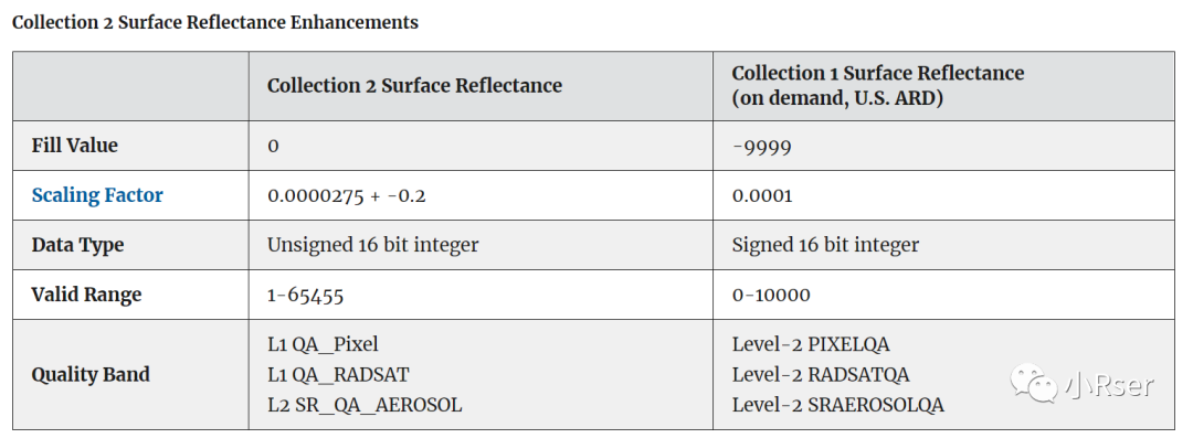
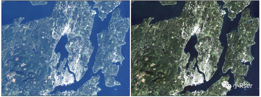
数据样例:
相关链接:
https://www.usgs.gov/landsat-missions/landsat-collection-2-surface-reflectance
https://www.usgs.gov/landsat-missions/landsat-collection-2-level-2-science-products
Landsat Surface Temperature
Landsat Collection 2 Level-2的Landsat Surface Temperature与Landsat Collection 1数据产品规则大致一致。其比较重要的变化如下:
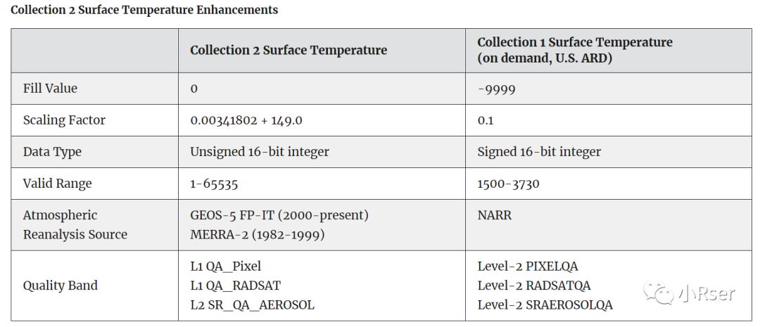
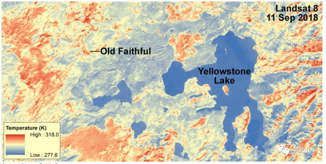
数据样例:
相关链接:
https://www.usgs.gov/landsat-missions/landsat-collection-2-level-2-science-products
https://www.usgs.gov/landsat-missions/landsat-collection-2-surface-temperature
Landsat Surface Reflectance-derived Spectral Indices
地表反射率反演的指数。
相关链接:
https://www.usgs.gov/landsat-missions/landsat-surface-reflectance-derived-spectral-indices
Level-3
Landsat Collection 2 Level-3包含以下数据数据产品:

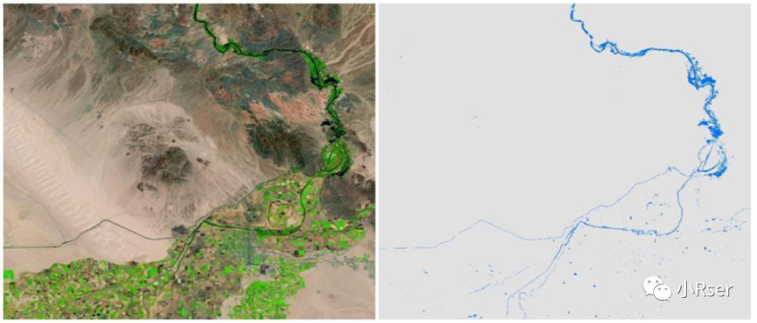
Dynamic Surface Water Extent
Landsat Collection 2 Level-3的Dynamic Surface Water Extent是Landsat Collection 1升级和延续版本,在高置信度水等级中存在极好的一致性。
时间范围1982年12月-至今,包含Landsat4-5(TM)、Landsat7(ETM+)、Landsat8(OLI),后续Landsat9数据也可提供下载. Landsat C2 DSWE产品包括六个GeoTiff栅格图层和一个与地表水的存在和状况相关的.xml元数据文件。
文件格式:
数据样例
相关链接:
https://www.usgs.gov/landsat-missions/landsat-collection-2-level-3-dynamic-surface-water-extent-science-product
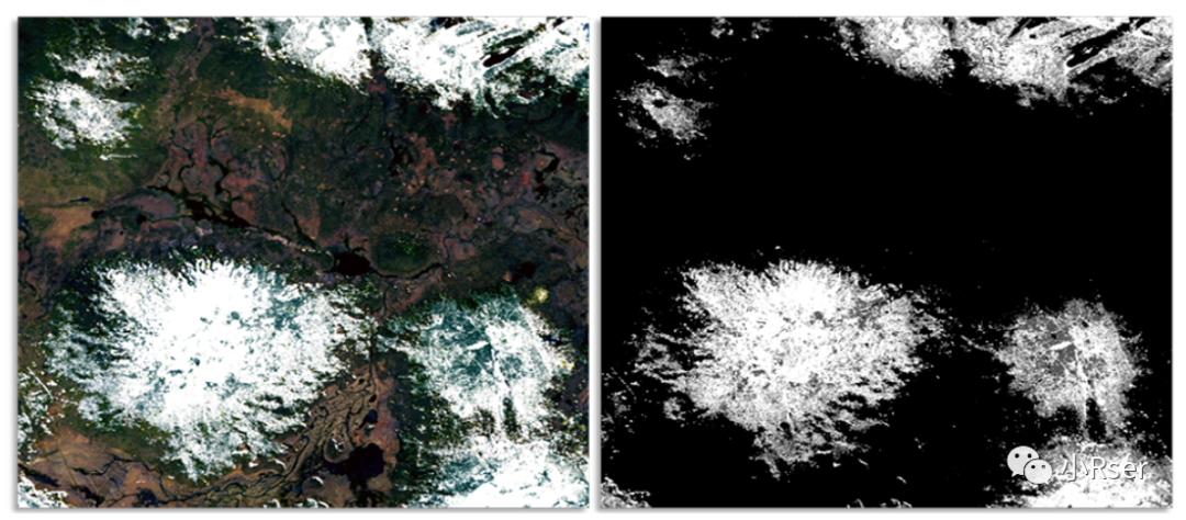
Fractional Snow Covered Area
Landsat Collection 2 Level-3的Fractional Snow Covered Area是Landsat Collection 1升级和延续版本。
时间范围1982年3月-至今,包含Landsat4-5(TM)、Landsat7(ETM+)、Landsat8(OLI),后续Landsat9数据也可提供下载.
文件格式:
数据样例:
相关链接:
https://www.usgs.gov/landsat-missions/landsat-collection-2-level-3-fractional-snow-covered-area-science-product
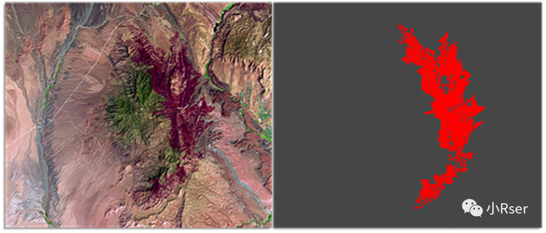
Burned Area
Landsat Collection 2 Level-3的Burned Area是Landsat Collection 1升级和延续版本。时间范围1982年3月-至今,包含Landsat4-5(TM)、Landsat7(ETM+)、Landsat8(OLI),后续Landsat9数据也可提供下载.Landsat C2 BA产品包括两个栅格数据文件,分别代表燃烧分类和燃烧概率。
文件格式:
数据样例:
相关链接:
https://www.usgs.gov/landsat-missions/landsat-collection-2-level-3-burned-area-science-product


 被折叠的 条评论
为什么被折叠?
被折叠的 条评论
为什么被折叠?
 到【灌水乐园】发言


