


| 地理信息系统中最重要的东西莫过于就是数据了,而且我接触GeoTools的本意就是利用其处理众多标准的Gis格式文件的能力。所以首先从GeoTools的Data模块着手来开始学习GeoTools。
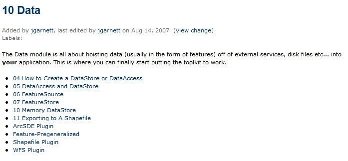
Data模块的定义见 http://docs.codehaus.org/display/GEOTDOC/10+Data
最后一句说明了这个模块的重要性:P
|
| 因为Data模块的类很多,但是无外乎就是处理各种GIS文件格式(Shape,mif/mid…)。下面学习Data模块主要以处理Shapefile格式相关的部分。其他格式文件类似。
上面这张图来自 http://docs.codehaus.org/display/GEOTDOC/10+Data 是官方网站上学习和阐述Data模块的资料列表
下面就这张图的顺序记录下学习Data模块的心得。
主要是下面几个类概括了整个Data模块的作用,需要特别注意: DataStore DataAccess FeatureSource FeatureStore |
| http://docs.codehaus.org/display/GEOTDOC/10+Memory+DataStore
Memory DataStore用来在内存中模拟一个数据源。而不是从某个输入端加载进来的(网络,Shapefile,mid/mid…)
例如可以创建一个数据源,加入部分需要保存的空间数据,然后整体保存到Shapefile或者mif或者其他格式。。:P
如果在MemoryDataStrore中添加修改删除空间数据,添加修改删除空间数据的属性,见 http://docs.codehaus.org/display/GEOTDOC/10+Memory+DataStore
|
| 11 Exporting to A Shapefile见http://docs.codehaus.org/display/GEOTDOC/11+Exporting+to+A+Shapefile
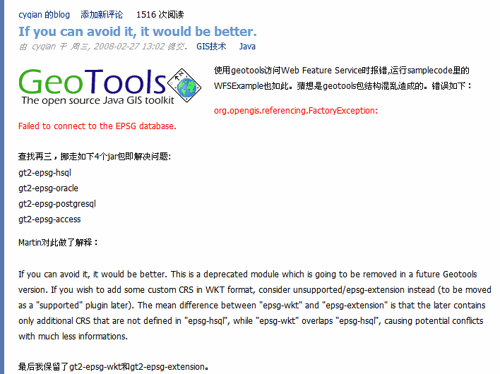
下面是一个完整的课运行的例子!在跑这个例子的时候出现了小插曲,就是报了一个不是初学者能解决的错误,莫名其妙的:)错误是Fail to connect to ESPG connection,我的版本是GeoTools2.5.5在网上查了下原因,也解决这个问题,在这里顺便把解决这个问题的解决方法给贴出来,在测试这些例子的时候发现GeoTools的API使用起来不是太舒服,好多类名字在不同包里有相同的名字,可能是我理解的不是太深,但是对于初学者,这个学习的阻抗还是大了点:)
|
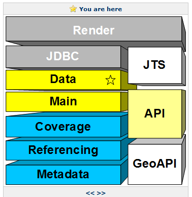
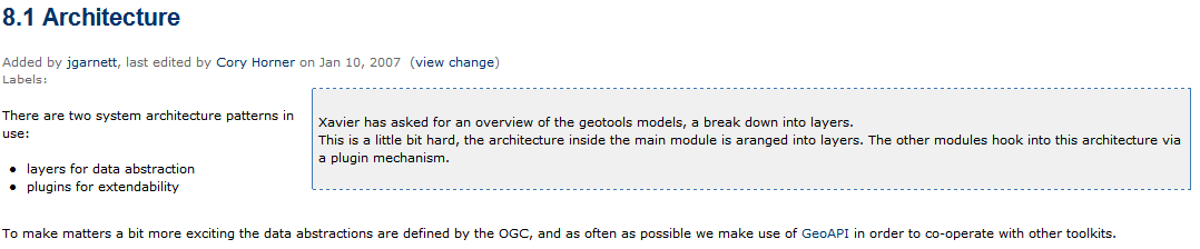
| http://docs.codehaus.org/display/GEOTDOC/Shapefile+Plugin GeoTools对 shapefile文件格式的支持是以插件的形式提供的,GeoTools的框架结构还是很有趣的,通过像TCP协议一样的分层结构来做到分离,然后在每层上提供plugin的嵌入,非常简洁优美的结构。见下图,图片来自http://docs.codehaus.org/display/GEOT/8.1+Architecture
其他对ArcSDE,WFS的支持都是类似的,在官网中没有放一个完整的操作shapefile的代码,在这里放上一个完整的demo,可以直接运行!
|


 2365
2365

 被折叠的 条评论
为什么被折叠?
被折叠的 条评论
为什么被折叠?
 到【灌水乐园】发言


