


参考:http://www.cnblogs.com/zhangjun1130/archive/2010/05/26/1744472.html
Geoprocessing是ArcGIS提供的一个非常实用的工具,借由Geoprocessing工具可以方便的调用ArcToolBox中提供的各类工具,本文在ArcEngine9.2平台环境下总结了调用ArcToolBox工具的使用方法:
1、调用ArcToolBox工具方法
以ArcToolBox->Analysis Tools->Proximity->Buffer工具的调用为例,C#代码如下:
using ESRI.ArcGIS.AnalysisTools; //添加引用
using ESRI.ArcGIS.Geoprocessor;
Geoprocessor gp = new Geoprocessor(); //初始化Geoprocessor
gp.OverwriteOutput = true; //允许运算结果覆盖现有文件
ESRI.ArcGIS.AnalysisTools.Buffer pBuffer = new ESRI.ArcGIS.AnalysisTools.Buffer(); //定义Buffer工具
pBuffer.in_features = pVorLineLayer; //输入对象,既可是IFeatureLayer对象,也可是完整文件路径如“D:\\data.shp”
pBuffer.out_feature_class = pBuffer; //输出对象,一般是包含输出文件名的完整文件路径,如“D:\\buffer.shp”
//设置缓冲区的大小,即可是带单位的具体数值,如0.1 Decimal Degrees;也可是输入图层中的某个字段,如“BufferLeng”
pBuffer.buffer_distance_or_field = "BufferLeng";
pBuffer.dissolve_option = "ALL"; //支持融合缓冲区重叠交叉部分
gp.Execute(pBuffer, null); //执行缓冲区分析
2、参数设置
在调用ArcToolBox执行具体的分析操作时,需要设置各类输入输出参数,简单概括起来说主要分为两类:对应于Environment Settings对话框的Geoprocessor对象设置、对应于具体操作窗口的方法设置。以ArcToolBox->Analysis Tools->Overlay->Intersect为例,C#代码如下:
Geoprocessor gp = new Geoprocessor();
gp.OverwriteOutput = true; //覆盖原有文件并重写
//Environment Settings对话框参数设置,具体名称参考操作界面Help中对应参数文档
object obj = gp.GetEnvironmentValue("Extent"); //设置Exten,大小写无关;
gp.SetEnvironmentValue("Extent", "MAXOF"); //或者"113.697050 115.074770 29.969986 31.362495"
obj = gp.GetEnvironmentValue("OutputZFlag"); //设置Output has Z Values
gp.SetEnvironmentValue("OutputZFlag", "DEFAULT");
obj = gp.GetEnvironmentValue("OutputMFlag"); //设置Output has M Values
gp.SetEnvironmentValue("OutputMFlag", "DEFAULT");
obj = gp.GetEnvironmentValue("OutputCoordinateSystem"); //设置Output Coordinate System
gp.SetEnvironmentValue("OutputCoordinateSystem", Application.StartupPath + "\\zhouyang.prj");
obj = gp.GetEnvironmentValue("QualifiedFieldNames"); //设置Maintain fully qualifid field names
gp.SetEnvironmentValue("QualifiedFieldNames", "QUALIFIED");
//具体操作窗口的方法设置
Intersect pIntersect = new Intersect();
//多个对象的输入:用分号隔开包含完整路径的文件名
pIntersect.in_features = pInputFeature1 + ";" + pInputFeature2;
//多个对象的输入:使用IGpValueTableObject接口,该接口可以设置Rank(http://resources.esri.com/help/9.3/arcgisengine/dotnet/84349562-e062-44ee-8db0-9fcdcd64708b.htm)
//object inputfeature1 = @"D:\周杨\贝贝\WuhanCity\ThiessenPolygons_Line_Buffer.shp";
//object inputfeature2 = @"D:\周杨\贝贝\wuhanCity_shp\poi Point.shp";
//IGpValueTableObject pObject = new GpValueTableObjectClass();
//pObject.SetColumns(2);
//pObject.AddRow(ref inputfeature1);
//pObject.AddRow(ref inputfeature2);
//pIntersect.in_features = pObject;
pIntersect.out_feature_class = pOutputFeature;
pIntersect.join_attributes = "All";
pIntersect.output_type = "POINT";
gp.Execute(pIntersect, null); //执行
3、运行结果对象提取
Geoprocessor对象通过Execute方法执行后将结果保存到指定输出路径下,通过也可以通过IGeoProcessorResult接口读取存储在内容中的结果对象,C#代码如下:
//执行图层求交运算
IGeoProcessorResult pResult = (IGeoProcessorResult)gp.Execute(pIntersect, null);
IGPUtilities pGPUtil = new GPUtilitiesClass();
IFeatureClass pFC;
IQueryFilter pQF;
pGPUtil.DecodeFeatureLayer(pResult.GetOutput(0),out pFC,out pQF);
int count = pFC.FeatureCount(null); //统计Feature对象个数
IFeatureCursor pCursor = pFC.Insert(true); //提取FeatureCursor对象
IFeatureLayer pFeatureLayer = new FeatureLayerClass();
pFeatureLayer.FeatureClass = pFC;
m_mapControl.Map.AddLayer(pFeatureLayer); //加载图层对象
运行自定义的geoprocessing工具
除了使用现有的工具和ESRI提供的工具箱,也可以执行你自定义的工具,比如model tools(模型工具)和script tools(脚本工具),他们存在于自定义工具箱中。使用集成开发环境(IDE)框架嵌入在Visual Studio .NET中,你可以生成geoprocessing程序集用来重现任何自定义工具箱。这样做,使用ArcGIS Toolbox Reference对话框。
引用名称执行工具
声明你的自定义工具箱并不是生成geoprocessing程序集的先决条件。这里有另外一种使用geoprocessor的方式来使用Execute方法。Execute方法已经被重载和附加,允许您通过指定工具的名称、工具的参数和ITrackCancel接口来执行工具。
下面是一个执行计算最优路径模型的工具,它位于BestPath工具箱中:
    using ESRI.ArcGIS.Geoprocessor;
    using ESRI.ArcGIS.esriSystem;

    public void SampleCalculateBestPathTool()
    {

      // Initialize the geoprocessor.
      Geoprocessor GP = new Geoprocessor();

      // Add the BestPath toolbox.
      GP.AddToolbox(@"C:\SanDiego\BestPath.tbx");

      // Generate the array of parameters.
      IVariantArray parameters = new VarArrayClass();
      parameters.Add(@"C:\SanDiego\source.shp");
      parameters.Add(@"C:\SanDiego\destination.shp");
      parameters.Add(@"C:\SanDiego\bestpath.shp");

      // Execute the model tool by name.
      GP.Execute("CalculateBestPath", parameters, null);
    }
执行geoprocessing server工具
通过ArcGIS Desktop和ArcGIS Engine(9.2及以上版本),你可以执行发布在ArcGIS Server上的geoprocessing工具。Server工具能通过像自定义工具一样执行。首先你必须添加工具箱,这个工具箱是生成一个geoprocessing toolbox assembly来表示或使用AddToolbox方法添加自定义的。
工具箱能够发布在局域网(LAN)或者作为一个Web服务发布在Internet上。要想使用geoprocessing服务工具,你必须添加工具箱。下面的示例代码显示了如何使用AddToolbox方法添加发布在ArcGIS Server的工具。
using ESRI.ArcGIS.Geoprocessor;

public void SampleGeoprocessingServerTool(Geoprocessor GP)
{

  // Add the BestPath toolbox published on a LAN.
  // Entered as server name;folder/toolbox.
  GP.AddToolbox(@"flame7;SanDiego/BestPath");

  // Add the BestPath toolbox published as a geoprocessing Web service.
  // Entered as Web service;folder/toolbox.
  GP.AddToolbox(@"http://flame7/arcgis/services;SanDiego/BestPath");

  //TODO: Add your code here...
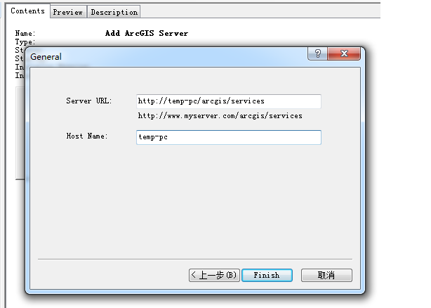
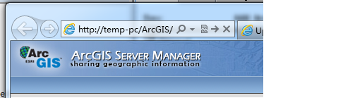
其中在arccatalog中添加GIS Server时 host Name同 arcgis server manager 打开时的网址中的内容如:


则添加工具代码为:
GP.AddToolbox(@"http://192.168.0.200:8399/arcgis/services;tt/tbx");
如果无端口号信息则:
则添加工具代码为:
GP.AddToolbox(@"http://temp-pc/arcgis/services;tt/tbx");


 327
327


 被折叠的 条评论
为什么被折叠?
被折叠的 条评论
为什么被折叠?
 到【灌水乐园】发言


