


通过Redis拓展的GEO数据类型查询两地之间的距离
最近了解到redis还有几种拓展数据类型,GEO,hyperLogLog,bitmaps
GEO
GEOADD locations 116.419217 39.921133 beijin
GEOPOS locations beijin
GEODIST locations tianjin beijin km 	计算距离
GEORADIUSBYMEMBER locations beijin 150 km  通过距离计算城市
注意:没有删除命令  它的本质是zset  (type locations)
所以可以使用zrem key member  删除元素
zrange key  0   -1  表示所有   返回指定集合中所有value
hyperLogLog
Redis 在 2.8.9 版本添加了 HyperLogLog 结构。
Redis HyperLogLog 是用来做基数统计的算法,HyperLogLog 的优点是,在输入元素的数量或者体积非常非常大时,计算基数所需的空间总是固定 的、并且是很小的
在 Redis 里面,每个 HyperLogLog 键只需要花费 12 KB 内存,就可以计算接近 2^64 个不同元素的基 数。这和计算基数时,元素越多耗费内存就越多的集合形成鲜明对比。
PFADD 2017_03_06:taibai 'yes' 'yes' 'yes' 'yes' 'no'
PFCOUNT 2017_03_06:taibai    统计有多少不同的值
1.PFADD 2017_09_08:taibai uuid9 uuid10 uu11
2.PFMERGE 2016_03_06:taibai 2017_09_08:taibai   合并
注意:本质还是字符串 ,有容错率,官方数据是0.81%
bitmaps
setbit taibai 500000 0
getbit taibai 500000
bitcount taibai
Bitmap本质是string,是一串连续的2进制数字(0或1),每一位所在的位置为偏移(offset)。
string(Bitmap)最大长度是512 MB,所以它们可以表示2 ^ 32=4294967296个不同的位。
代码部分
1.pom.xml
<dependencies>
        <dependency>
            <groupId>org.springframework.boot</groupId>
            <artifactId>spring-boot-starter-data-elasticsearch</artifactId>
        </dependency>

        <dependency>
            <groupId>org.springframework.boot</groupId>
            <artifactId>spring-boot-starter-data-redis</artifactId>
        </dependency>

        <dependency>
            <groupId>mysql</groupId>
            <artifactId>mysql-connector-java</artifactId>
            <scope>runtime</scope>
        </dependency>
        <dependency>
            <groupId>org.projectlombok</groupId>
            <artifactId>lombok</artifactId>
            <optional>true</optional>
        </dependency>
        <dependency>
            <groupId>org.springframework.boot</groupId>
            <artifactId>spring-boot-starter-test</artifactId>
            <scope>test</scope>
            <exclusions>
                <exclusion>
                    <groupId>org.junit.vintage</groupId>
                    <artifactId>junit-vintage-engine</artifactId>
                </exclusion>
            </exclusions>
        </dependency>

    </dependencies>
2.application.yml
spring:
  redis:
    host: localhost
    port: 6379
3.测试代码
import org.junit.jupiter.api.Test;
import org.springframework.boot.test.context.SpringBootTest;
import org.springframework.data.geo.Distance;
import org.springframework.data.geo.Point;
import org.springframework.data.redis.connection.RedisGeoCommands;
import org.springframework.data.redis.core.GeoOperations;
import org.springframework.data.redis.core.RedisTemplate;

import javax.annotation.Resource;

@SpringBootTest
class SpringbootDemoApplicationTests {

    @Resource
    private RedisTemplate<String, Object> redisTemplate;

    @Test
    void testGetDistance() {

        GeoOperations<String, Object> geoOperations = redisTemplate.opsForGeo();
        //首先存入客户端上传的经纬度和指定地点的经纬度
        // 将这些地址数据保存到redis中
        geoOperations.add("GET_DISTANCE", new Point(116.40, 39.90), "beijing");
        geoOperations.add("GET_DISTANCE", new Point(117.20, 39.12), "tianjin");
        // 调用方法,计算天津与北京之间的距离;单位为KM
        Distance distance = geoOperations.distance("GET_DISTANCE", "tianjin", "beijing", RedisGeoCommands.DistanceUnit.KILOMETERS);
        double value = distance == null ? 0 : distance.getValue();
        System.out.println(value);

    }

}
redis :
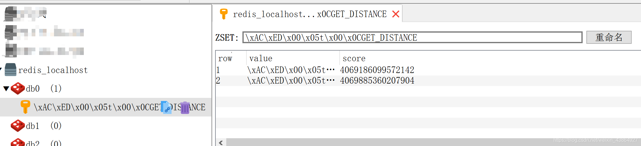
结果:

网上使用工具查询接口
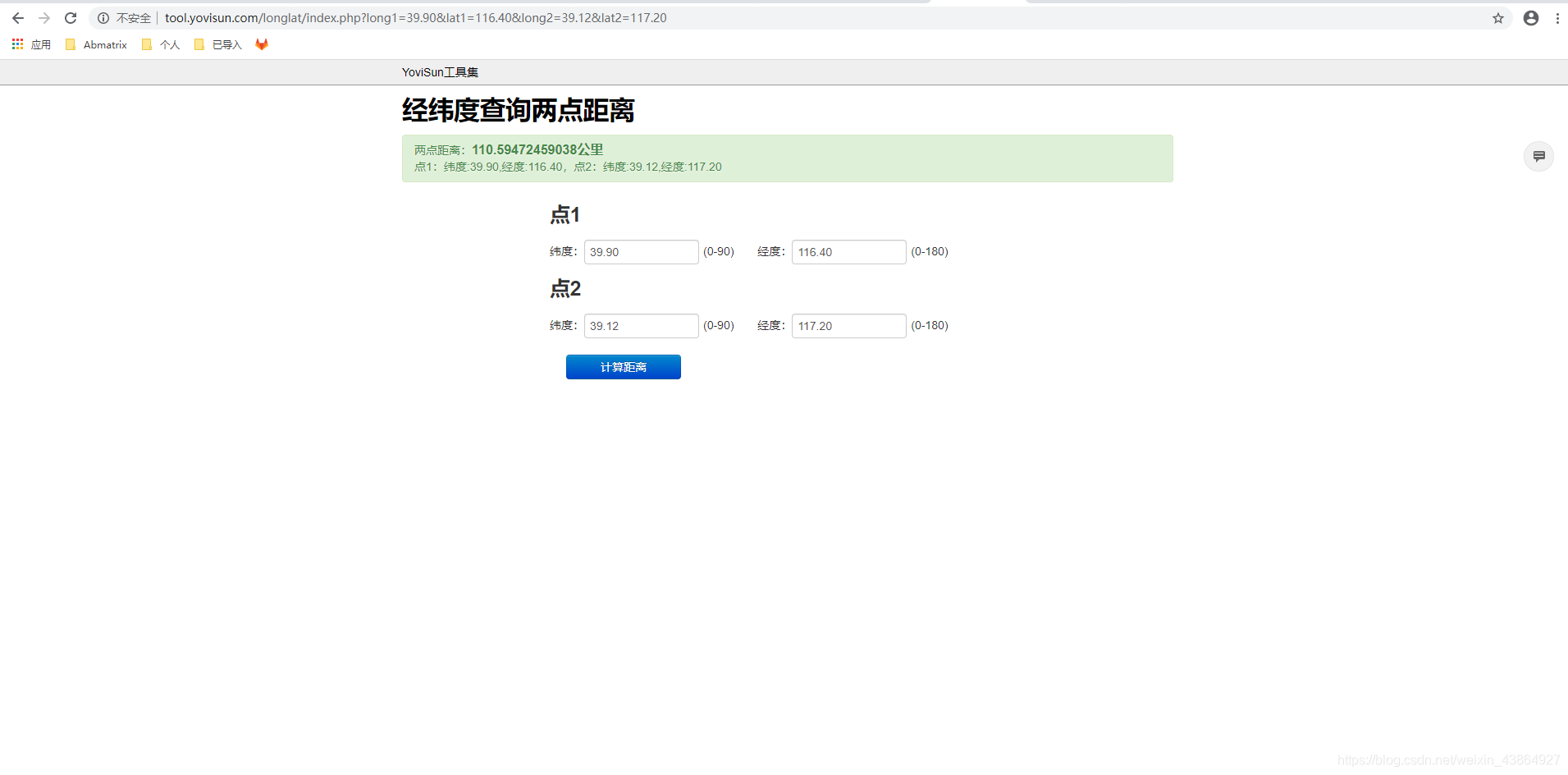


 6331
6331


 被折叠的 条评论
为什么被折叠?
被折叠的 条评论
为什么被折叠?
 到【灌水乐园】发言


