


背景:当初做3dMax模型导入到ArcGIS中的multipatch中过程中,一般一个3dmax(.max)文件中会包括几栋建筑物,在导出到ArcGIS过程中,再和地形图生成的系统数据和DEM进行检验时,发现平面精度即X、Y坐标匹配的比较好,但是高程并不理想,发现同一个3dMax文件中导出的几个建筑物和DEM的高程有误差,而且每个建筑物误差大小不一致。这个就需要将3dMax文件中每个建筑物进行提取,然后单个建筑物生成的Max文件导入到ArcGIS中,然后根据DEM进行纠正。
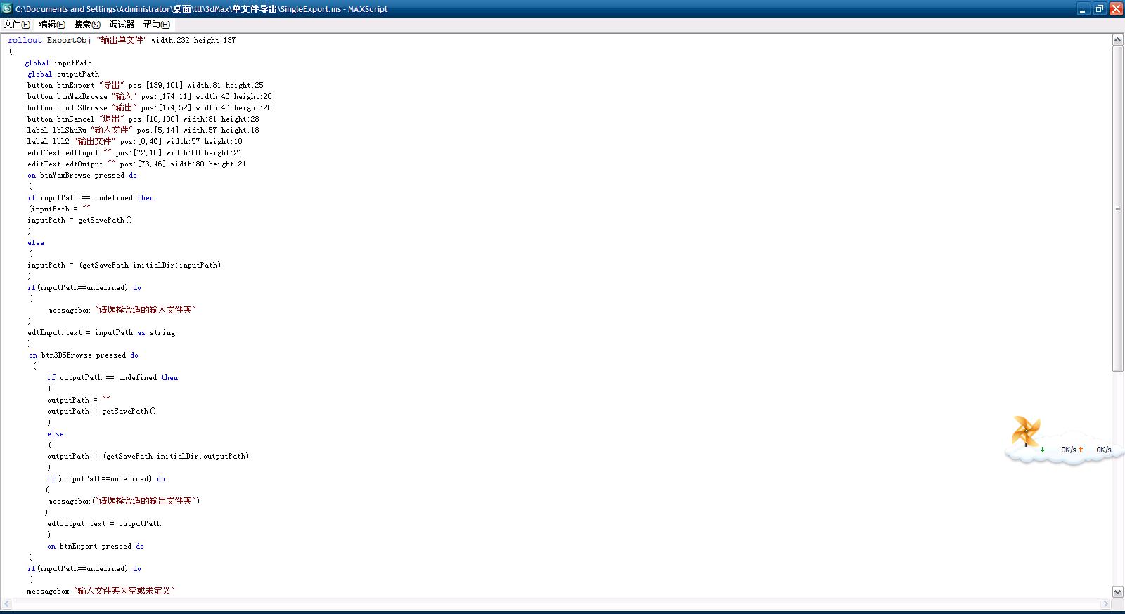
rollout ExportObj "输出单文件" width:232 height:137
(
global inputPath
global outputPath
button btnExport "导出" pos:[139,101] width:81 height:25
button btnMaxBrowse "输入" pos:[174,11] width:46 height:20
button btn3DSBrowse "输出" pos:[174,52] width:46 height:20
button btnCancel "退出" pos:[10,100] width:81 height:28
label lblShuRu "输入文件" pos:[5,14] width:57 height:18
label lbl2 "输出文件" pos:[8,46] width:57 height:18
editText edtInput "" pos:[72,10] width:80 height:21
editText edtOutput "" pos:[73,46] width:80 height:21
on btnMaxBrowse pressed do
(
if inputPath == undefined then
(inputPath = ""
inputPath = getSavePath()
)
else
(
inputPath = (getSavePath initialDir:inputPath)
)
if(inputPath==undefined) do
(
messagebox "请选择合适的输入文件夹"
)
edtInput.text = inputPath as string
)
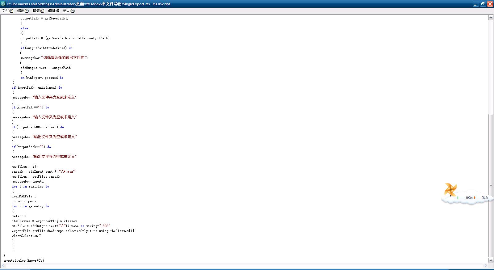
on btn3DSBrowse pressed do
(
if outputPath == undefined then
(
outputPath = ""
outputPath = getSavePath()
)
else
(
outputPath = (getSavePath initialDir:outputPath)
)
if(outputPath==undefined) do
(
messagebox("请选择合适的输出文件夹")
)
edtOutput.text = outputPath
)
on btnExport pressed do
(
if(inputPath==undefined) do
(
messagebox "输入文件夹为空或未定义"
)
if(inputPath=="") do
(
messagebox "输入文件夹为空或未定义"
)
if(outputPath==undefined) do
(
messagebox "输出文件夹为空或未定义"
)
if(outputPath=="") do
(
messagebox "输出文件夹为空或未定义"
)
maxfiles = #()
inpath = edtInput.text + "\\*.max"
maxfiles = getFiles inpath
messagebox inpath
for f in maxfiles do
(
loadMAXFile f
print objects
for i in geometry do
(
select i
theClasses = exporterPlugin.classes
strFile = edtOutput.text+"\\"+i.name as string+".3DS"
exportFile strFile #noPrompt selectedOnly:true using:theClasses[1]
clearSelection()
)
)
)
)
createdialog ExportObj2.以下是3dmax9中的脚本代码图片:
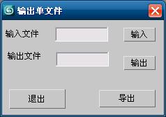
3.以下是运行结果图:


 946
946

 被折叠的 条评论
为什么被折叠?
被折叠的 条评论
为什么被折叠?
 到【灌水乐园】发言


