


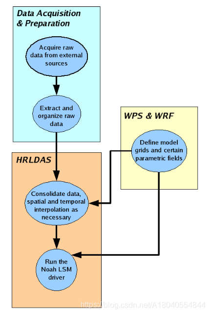
运行结构:
1、所需的数据
初始场数据:
●Soil temperature (at multiple levels).●Soil moisture (at multiple levels).●Canopy water content.●Skin temperature.●Water equivalent of accumulated snow depth.
强迫场数据:
●Nearsurface air temperature.●Sourcemodel terrain elevation (for adjusting nearsurface air temperature to destinationmodel surface elevation).●Nearsurface atmospheric mixing ratio.●Nearsurface ucomponent of the horizontal wind (gridrelative).●Nearsurface vcomponent of the horizontal wind (gridrelative).●Surface pressure.●Precipitation rate.●Downward shortwave radiation flux at the surface.●Downward longwave radiation flux at the surface.
参数字段(用于定义soil、vegetation以及其他地理参数(geographical parameters)的数据),这些参数字段由WRF过程产生:
●Latitude●Longitude●Vegetation category●Soil category●Green vegetation fraction●A minimum green vegetation fraction for a typical year at a given point●A maximum green vegetation fraction for a typical year at a given point●A timeinvariant deepsoil temperature
初始时需要参数字段,在HRLDAS集成过程中可能会适当地更新某些字段。
2、数据获取与组织
数据获取与组织可能是运行HRLDAS中最困难和最耗时的一项工作了。HRLDAS确定了组织原始数据的最合适方式,即每次将每个2-d字段存储为包含单个GRIB (Edition 1或Edition 2)记录的单个GRIB文件。由于GRIB是WMO存档和分发网格化气象数据的标准,因此HRLDAS所需的许多领域都已以GRIB格式提供,而且在整个社区中,有许多工具可用于操作和可视化GRIB数据集。
3、为HRLDA准备模型配置
3.1 GEO_EM FILES
HRLDAS是基于Noah LSM的天气研究和预报模型(WRF)的实现。因此,HRLDAS需要为WRF准备的某些文件和字段。为HRLDAS创建这些文件的最简单的方法是准备输入到WRF模型的数据,即运行WRF预处理系统(WPS)和WRF程序real.exe。
其策略是像WRF仿真那样建立模型网格和模型输入文件,然后使用这些文件来运行HRLDAS而不是WRF。HRLDAS不直接处理嵌套,但HRLDAS可以独立运行多个域。如果需要嵌套的HRLDAS数据,必须在多个域上运行WPS和WRF程序real.exe。
WPS中的geogrid.exe会产生geo_em.d<nn>文件,但仅少量的geo_em.d<nn>信息是HRLDAS所需要的。需要从geo_em文件中获取的数据有:
Required NetCDF dimensions in the geo_em file:
- west_east:The number of grid cells in the X direction.
- south_north:The number of grid cells in the Y direction.
- month:The number of months in the year (12), used as a dimension for the monthly mean greenvegetation fraction variable, which has one field per month.
- Time:The number of time periods in the NetCDF file; should be equal to 1. The Time dimension is theunlimited dimension in the NetCDF dataset.
Required NetCDF global attributes in the geo_em file:
- MAP_PROJ:
An integer flag identifying the map projection used. Three map projections are recognized:
MAP_PROJ=1 :: Lambert Conformal
MAP_PROJ=2 :: Polar Stereographic
MAP_PROJ=3 :: Mercator
- DX:The gridcell size (m) in the X direction.(DY is usually equal to DX.)
- DY:The gridcell size (m) in the Y direction.
- TRUELAT1:
A “true” latitude, or standard parallel, used in the definition of some map projections, whichindicates where the plane of the projection intersects the earth. TRUELAT1 is used for the PolarStereographic and Lambert Conformal map projections.
- TRUELAT2A :
second “true” latitude, or standard parallel, used in the definition of the Lambert Conformalmap projection. For the Lambert Conformal map projection, TRUELAT2 indicates a secondlatitude (in addition to TRUELAT1) where the plane of the projection intersects the earth.
- STAND_LON:
The central longitude of the map projection (not necessarily of the map grid itself) used in thedefinition of some map projections. STAND_LON is the longitude that is parallel to the Yaxis.
- MMINLU:
A string identifying the source of the landuse categories, which determines the mapping frominteger landuse categories to physical landuse characteristics. The only formally recognizedvalue for MMINLU is “USGS”.
Required NetCDF fields in the geo_em file:
- XLAT_M (or XLAT):
2dimensional latitude field (dimensioned west_east by south_north).
- XLONG_M (or XLONG):
2dimensional longitude field (dimensioned west_east by south_north).
- GREENFRAC:
Monthly climatological green vegetation fraction (dimensioned west_east by south_north by 12months).
example:minimal geo_em contents
netcdf geo_em {
dimensions:
Time = UNLIMITED ; // (1 currently)
month = 12 ;
south_north = 239 ;
west_east = 279 ;
variables:
float GREENFRAC(Time, month, south_north, west_east) ;
float XLAT_M(Time, south_north, west_east) ;
float XLONG_M(Time, south_north, west_east) ;
// global attributes:
:DX = 12000.f ;
:DY = 12000.f ;
:TRUELAT1 = 30.f ;
:TRUELAT2 = 60.f ;
:STAND_LON = -98.f ;
:MAP_PROJ = 1 ;
:MMINLU = "USGS" ;
}
3.2 WRFINPUT FILES
WRF程序real.exe为输入WRF模型准备文件。WPS程序(aftergeogrid.exe)和WRF程序real.exe需要依赖时间的字段来建立特定日期的预报。然而,由于HRLDAS只使用这些文件中的常量字段,wps和real.exe的实际运行时间并不重要。只需选择一组方便的气象数据,通过WRF预处理程序运行即可。
与WPS类似,real.exe可以在多个域中运行,创建名为wrfinput d01、wrfinput d02、wrfinput d03的文件。HRLDAS使用来自wrfinput文件中的某个子集数据。同样,构造类似的包含这个最小的数据量的代理文件将很好地用于hrlda。
Required NetCDF Dimensions in the wrfinput file:
west_east:The number of grid cells in the X direction. This mus be the same as the west_east dimension inthe geo_em file.
south_north:The number of grid cells in the Y direction. This must be the same as the west_east dimension inthe geo_em file.
Required NetCDF global attributes in the wrfinput file:
- GRID_ID or grid_id:
Integer flag identifying the grid.
- MAP_PROJ:
An integer flag identifying the map projection used. This must be the same as the MAP_PROJ attribute in the geo_em file. Three map projections are recognized:
MAP_PROJ=1 :: Lambert Conformal
MAP_PROJ=2 :: Polar Stereographic
MAP_PROJ=3 :: Mercator
- STAND_LON:
The central longitude of the map projection (not necessarily of the map grid itself) used in thedefinition of some map projections. STAND_LON is the longitude that is parallel to the Yaxis.This attribute must have the same value as the STAND_LON attribute in the geo_em file
- TRUELAT1:
A “true” latitude, or standard parallel, used in the definition of some map projections, whichindicates where the plane of the projection intersects the earth. TRUELAT1 is used for the Polar.
Stereographic and Lambert Conformal map projections. This attribute must have the same valueas the TRUELAT1 global attribute in the geo_em file.
- TRUELAT2:
A second “true” latitude, or standard parallel, used in the definition of the Lambert Conformalmap projection. For the Lambert Conformal map projection, TRUELAT2 indicates a secondlatitude (in addition to TRUELAT1) where the plane of the projection intersects the earth. This attribute must have the same value as the TRUELAT2 global attribute in the geo_em file.
- DX:
The gridcell size (m) in the X direction. This attribute must have the same value as the DX global attribute in the geo_em file.
- DY:
The gridcell size (m) in the Y direction. DY is usually equal to DX. This attribute must have thesame value as the DY global attribute in the geo_em file.
- ISWATER:
The soil category which corresponds to water points.
- ISURBAN:
The vegetation category which corresponds to urban points
Required NetCDF Fields in the WRFINPUT file:
- XLAT (or XLAT_M)
2dimensional latitude field (degrees North). XLAT is dimensioned (west_east by south_north).This field must be the same as the XLAT_M field in the geo_em file.
- XLONG (or XLONG_M)
2dimensional longitude field (degrees East). XLONG is dimensioned west_east by south_north.This field must be the same as the XLONG_M field in the geo_em file.
- HGT
2dimensional surface elevation field (m).HGT is dimensioned west_east by south_north.
- IVGTYP
2dimensional array of vegetation category indices. IVGTYP is dimensioned west_east bysouth_north.
- ISLTYP
2dimensional array of soil category indices. ISLTYP is dimensioned west_east by south_north.
- TMN
2dimensional constant deepsoil temperature field (K) TMN is dimensioned west_east bysouth_north)
Example: Minimal wrfinput contents:
netcdf wrfinput {
dimensions:
Time = UNLIMITED ; // (1 currently)
south_north = 239 ;
west_east = 279 ;
variables:
float HGT(Time, south_north, west_east) ;
int ISLTYP(Time, south_north, west_east) ;
int IVGTYP(Time, south_north, west_east) ;
float TMN(Time, south_north, west_east) ;
float XLAT(Time, south_north, west_east) ;
float XLONG(Time, south_north, west_east) ;
// global attributes:
:DX = 12000.f ;
:DY = 12000.f ;
:GRID_ID = 1 ;
:TRUELAT1 = 30.f ;
:TRUELAT2 = 60.f ;
:STAND_LON = -98.f ;
:MAP_PROJ = 1 ;
:MMINLU = "USGS" ;
:ISWATER = 16 ;
:ISURBAN = 1 ;
}
4、数据整合步骤(consolidate_grib.exe)
consolidate_grib.exe的输入
namelist.list
wrfinput_d##
geo_em.d##
与namelist.input文件一致的grib-formatted source data
namelist.input文件选项
Vtable
略
5、强迫场
在最后的HRLDAS步骤中,每个小时的模拟周期中都必须有强迫场可用。原始数据源可以提供超过一个小时的数据。为了在HRLDAS中使用,合并的grib.exe程序可以插补到所需的每小时时间间隔
air temperature
atmosphereic mixing ratio
u-component of the horizontal wind
v-component of the horizontal wind
surface pressure
precipitation rate
shortwave radiation
longwave radiation
6、初始场
soil temperature
soil moisture
canopy water
skin temperature
water equivalent of the snow depth
7、参数场
VEGFRA
GVFMIN
GVFMAX
Z2D
TMN (TBOT)
8、hrldas执行Noah_hrldas_beta
本章详细介绍了运行HRLDAS可执行文件Noah HRLDAS测试版的细节。本章假设所有的数据收集和准备步骤都已经执行,HRLDAS程序已经正确编译,用户已经获得了完整的LDASIN文件套件,用户已经获得了相应的wrfinput文件(或类似的构造文件)。
noah_hrldas_beta输入
namelist.hrldas
<YYYYMMDDHH>.LDASIN_DOMAIN<domain>
Various *.TBL files
wrfinput_d0<domain> or similarlyconstructed file
(optional) RESTART.<YYYYMMDDHH>_DOMAIN<domain>
Noah_hrldas_beta运行
运行HRLDAS可执行文件的基本步骤是在文件名称列表中配置适当的名称列表操作。hrldas,并运行可执行Noah hrldas beta。这两个文件都在HRLDAS/Run目录中。切换到该目录,编辑名称列表,并运行Noah_hrldas_beta可执行文件。


 4万+
4万+

 被折叠的 条评论
为什么被折叠?
被折叠的 条评论
为什么被折叠?
 到【灌水乐园】发言


