


目录
GeoTools 简介
官网:https://geotools.org/
git:https://github.com/geotools/geotools
GeoTools 是一个开源的Java库,为地理空间数据提供工具。
安装
以 IntelliJ IDEA 为例,
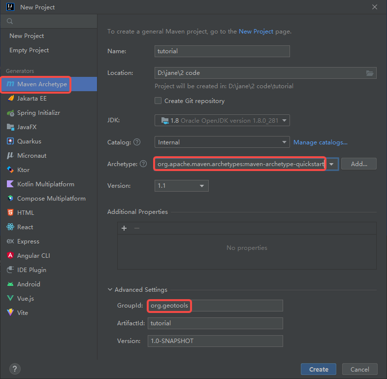
Step 1:新建项目
Step 2:修改pom文件
<project xmlns="http://maven.apache.org/POM/4.0.0" xmlns:xsi="http://www.w3.org/2001/XMLSchema-instance"
         xsi:schemaLocation="http://maven.apache.org/POM/4.0.0 http://maven.apache.org/xsd/maven-4.0.0.xsd">
    <modelVersion>4.0.0</modelVersion>

    <groupId>org.geotools</groupId>
    <artifactId>tutorial</artifactId>
    <version>1.0-SNAPSHOT</version>
    <packaging>jar</packaging>

    <name>tutorial</name>
    <url>http://maven.apache.org</url>
    <build>
        <plugins>
            <plugin>
                <inherited>true</inherited>
                <groupId>org.apache.maven.plugins</groupId>
                <artifactId>maven-compiler-plugin</artifactId>
                <version>3.10.1</version>
                <configuration>
                    <source>1.8</source>
                    <target>1.8</target>
                </configuration>
            </plugin>
        </plugins>
    </build>
    <properties>
        <java.version>1.8</java.version>
        <project.build.sourceEncoding>UTF-8</project.build.sourceEncoding>
        <geotools.version>26-SNAPSHOT</geotools.version>
        <maven.deploy.skip>true</maven.deploy.skip>
    </properties>

    <dependencies>
        <dependency>
            <groupId>junit</groupId>
            <artifactId>junit</artifactId>
            <version>4.13.2</version>
            <scope>test</scope>
        </dependency>
        <dependency>
            <groupId>org.geotools</groupId>
            <artifactId>gt-shapefile</artifactId>
            <version>${geotools.version}</version>
        </dependency>
        <dependency>
            <groupId>org.geotools</groupId>
            <artifactId>gt-swing</artifactId>
            <version>${geotools.version}</version>
        </dependency>
    </dependencies>
    <repositories>
        <repository>
            <id>osgeo</id>
            <name>OSGeo Release Repository</name>
            <url>https://repo.osgeo.org/repository/release/</url>
            <snapshots><enabled>false</enabled></snapshots>
            <releases><enabled>true</enabled></releases>
        </repository>
        <repository>
            <id>osgeo-snapshot</id>
            <name>OSGeo Snapshot Repository</name>
            <url>https://repo.osgeo.org/repository/snapshot/</url>
            <snapshots><enabled>true</enabled></snapshots>
            <releases><enabled>false</enabled></releases>
        </repository>
    </repositories>
</project>
Step 3:自动导入Maven依赖
Step 4:测试App.java
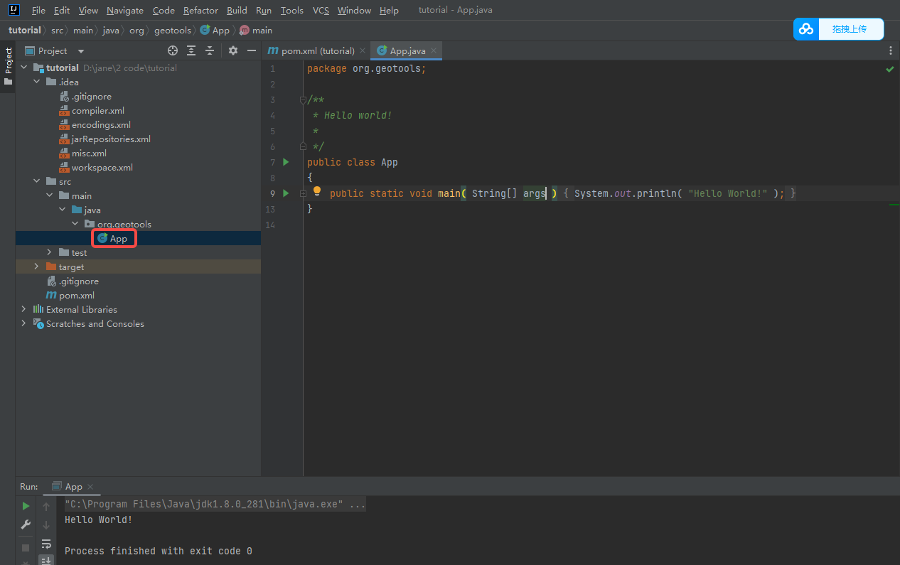
Hello world
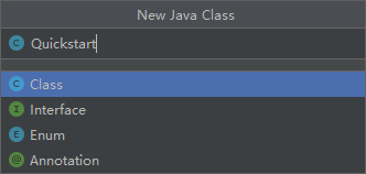
Step 1:在 App.java 同级目录下新建 Quickstart.java 并运行~
package org.geotools;
// 导入相应的包
import org.geotools.data.FileDataStore;
import org.geotools.data.FileDataStoreFinder;
import org.geotools.data.simple.SimpleFeatureSource;
import org.geotools.map.FeatureLayer;
import org.geotools.map.Layer;
import org.geotools.map.MapContent;
import org.geotools.styling.SLD;
import org.geotools.styling.Style;
import org.geotools.swing.JMapFrame;
import org.geotools.swing.data.JFileDataStoreChooser;

import java.io.File;
import java.util.logging.Logger;

public class Quickstart {

    private static final Logger LOGGER = org.geotools.util.logging.Logging.getLogger(Quickstart.class);

    /**
     * GeoTools Quickstart demo application.
     * Prompts the user for a shapefile and displays its contents on the screen in a map frame
     * 提示用户提供一个shp文件,并在屏幕上的地图窗口中显示其内容
     */
    public static void main(String[] args) throws Exception {
        // display a data store file chooser dialog for shapefiles
        LOGGER.info("Quickstart");
        LOGGER.config("Welcome Developers");
        LOGGER.info("java.util.logging.config.file=" + System.getProperty("java.util.logging.config.file"));

        // 打开文件选择器的弹窗
        File file = JFileDataStoreChooser.showOpenFile("shp", null); // JFileChooser
        if (file == null) {
            return;
        }
        LOGGER.config("File selected " + file);

        FileDataStore store = FileDataStoreFinder.getDataStore(file);
        SimpleFeatureSource featureSource = store.getFeatureSource();

        // Create a map content and add our shapefile to it
        MapContent map = new MapContent();
        map.setTitle("Quickstart");

        Style style = SLD.createSimpleStyle(featureSource.getSchema());
        Layer layer = new FeatureLayer(featureSource, style);
        map.addLayer(layer);

        // Now display the map
        JMapFrame.showMap(map);
    }
}
Step 2:弹窗并选择shp文件

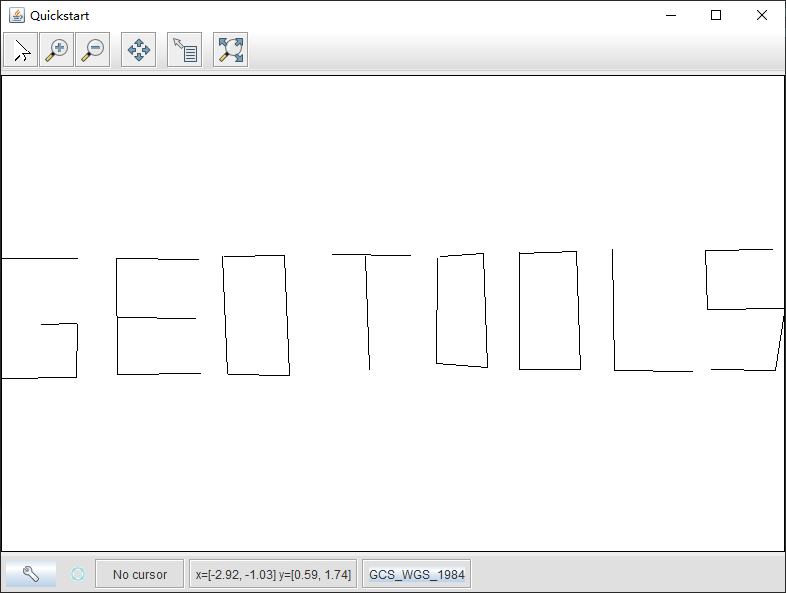
Step 3:窗口显示shp文件内容


 3615
3615


 被折叠的 条评论
为什么被折叠?
被折叠的 条评论
为什么被折叠?
 到【灌水乐园】发言


