


原文作者:我辈李想
版权声明:文章原创,转载时请务必加上原文超链接、作者信息和本声明。
前言
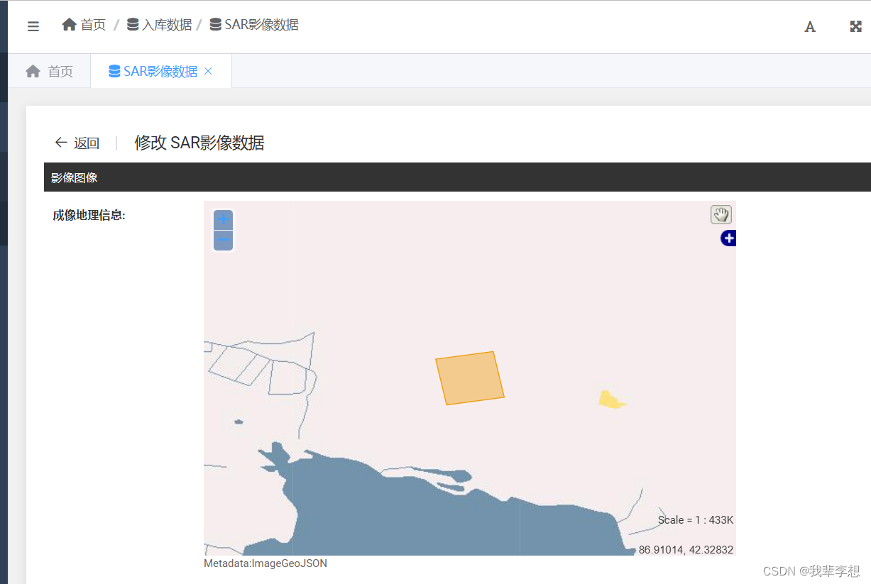
在前面的博客中,我们已经介绍了Geodjango的环境搭建和数据库操作,django本身提供了amdin后台,其实geodjango也有后台页面,现在我们来试着使用admin显示地图并加载空间字段。
一、django+admin
首先我们应该对django使用admin后台有一定基础,可以简单实现后台增删改查数据。
models.py文件如下
from django.contrib.gis.db import models
from django.utils import timezone

class SarPic(models.Model):
	...
    ImageGeoJSON = models.PolygonField('成像地理信息', null=True, help_text='Metadata:ImageGeoJSON')
    ...
    class Meta:
        verbose_name = '数据'
        verbose_name_plural = verbose_name
admin.py文件如下
from django.contrib import admin
from sarimage.models import SarPic

class SarPicAdmin(admin.ModelAdmin):
    list_display = ['ProductID',  'create_time', 'alter_time']
    list_per_page = 50
    list_filter = ['ImagingTime', 'SatellitePlatform', 'missionDataTakeId', 'SensorMode']
    # search_fields = ['ProductID', 'ImagingTime', 'SatelliteName', 'missionDataTakeId']
    fieldsets = (
        ('影像图像', {
            'fields': ('ImageGeoJSON',)
        })
    )

admin.site.register(SarPic, SarPicAdmin)
二、geodjango+admin
这里的变化为admin.ModelAdmin改为GeoModelAdmin(基于OpenLayers),除此之外还可以改成OSMGeoAdmin(基于OpenStreetMap)或LeafletGeoAdmin(基于Leaflet框架的第三方库django-leaflet)。
admin.py文件如下
from django.contrib import admin
from django.contrib.gis.admin import GeoModelAdmin
from sarimage.models import SarPic

class SarPicAdmin(GeoModelAdmin):
    list_display = ['ProductID',  'create_time', 'alter_time']
    list_per_page = 50
    list_filter = ['ImagingTime', 'SatellitePlatform', 'missionDataTakeId', 'SensorMode']
    # search_fields = ['ProductID', 'ImagingTime', 'SatelliteName', 'missionDataTakeId']
    fieldsets = (
        ('影像图像', {
            'fields': ('ImageGeoJSON',)
        })
    )
    default_lon  # 默认的中心经度。
	default_lat  # 默认的中心纬度。
	default_zoom  # 要使用的默认缩放级别。默认值为4。
	extra_js  # 要包含的任何额外javascript的URL序列。
	map_template  # 重写用于生成javascript Slippy映射的模板。默认是 'gis/admin/openlayers.html' .
	map_width  # 地图的宽度,以像素为单位。默认值为600。
	map_height  # 地图的高度,以像素为单位。默认为400。
	openlayers_url  # 链接到Openlayers JavaScript的URL。默认为 'https://cdnjs.cloudflare.com/ajax/libs/openlayers/2.13.1/OpenLayers.js' .
    modifiable = False  # 禁用管理中现有几何图形字段的编辑

admin.site.register(SarPic, SarPicAdmin)
三、报错处理
按照第二部分设置后,会报错 django.template.exceptions.TemplateDoesNotExist: gis/admin/openlayers.html。
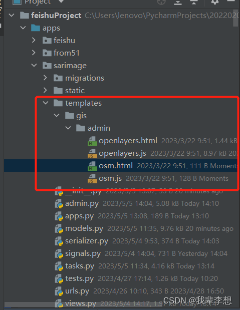
我不知道其他人遇到怎么处理的,网络上也没找相关方案。主要原因是django的版本不同,django库的文件存在差异,部分版本缺少geodjango的template文件夹,这个需要我们自己补全。
templates必须放入我们项目的app中,我的项目app是sarimage,models.py是空间数据的类。
from django.contrib.gis.admin import GeoModelAdmin
我使用的是geodjango默认的GeoModelAdmin,所以我需要的是openlayers.html和openlayers.js文件。
openlayers.html文件内容如下
{% block extrastyle %}
{% load i18n static %}{% get_current_language_bidi as LANGUAGE_BIDI %}
<style type="text/css">
  #{{ id }}_map { width: {{ map_width }}px; height: {{ map_height }}px; }
  #{{ id }}_map .aligned label { float:inherit; }
  #{{ id }}_admin_map { position: relative; vertical-align: top; z-index: 0; float: {{ LANGUAGE_BIDI|yesno:"right,left" }}; }
  {% if not display_wkt %}#{{ id }} { display: none; }{% endif %}
  .olControlEditingToolbar .olControlModifyFeatureItemActive {
     background-image: url("{% static "admin/img/gis/move_vertex_on.svg" %}");
     background-repeat: no-repeat;
  }
  .olControlEditingToolbar .olControlModifyFeatureItemInactive {
     background-image: url("{% static "admin/img/gis/move_vertex_off.svg" %}");
     background-repeat: no-repeat;
  }
</style>
{% endblock %}
<span id="{{ id }}_admin_map">
<script>
//<![CDATA[
{% block openlayers %}{% include "gis/admin/openlayers.js" %}{% endblock %}
//]]>
</script>
<div id="{{ id }}_map" dir="{{ LANGUAGE_BIDI|yesno:'rtl,ltr,auto' }}"></div>
{% if editable %}
<a href="javascript:{{ module }}.clearFeatures()">{% translate "Delete all Features" %}</a>
{% endif %}
{% if display_wkt %}<p>{% translate "WKT debugging window:" %} </p>{% endif %}
<textarea id="{{ id }}" class="vWKTField required" cols="150" rows="10" name="{{ name }}">{{ wkt }}</textarea>
<script>{% block init_function %}{{ module }}.init();{% endblock %}</script>
</span>
openlayers.js文件内容如下
{% load l10n %}
OpenLayers.Projection.addTransform("EPSG:4326", "EPSG:3857", OpenLayers.Layer.SphericalMercator.projectForward);
{% block vars %}var {{ module }} = {};
{{ module }}.map = null; {{ module }}.controls = null; {{ module }}.panel = null; {{ module }}.re = new RegExp("^SRID=\\d+;(.+)", "i"); {{ module }}.layers = {};
{{ module }}.modifiable = {{ modifiable|yesno:"true,false" }};
{{ module }}.wkt_f = new OpenLayers.Format.WKT();
{{ module }}.is_collection = {{ is_collection|yesno:"true,false" }};
{{ module }}.collection_type = '{{ collection_type }}';
{{ module }}.is_generic = {{ is_generic|yesno:"true,false" }};
{{ module }}.is_linestring = {{ is_linestring|yesno:"true,false" }};
{{ module }}.is_polygon = {{ is_polygon|yesno:"true,false" }};
{{ module }}.is_point = {{ is_point|yesno:"true,false" }};
{% endblock %}
{{ module }}.get_ewkt = function(feat){
    return 'SRID={{ srid|unlocalize }};' + {{ module }}.wkt_f.write(feat);
};
{{ module }}.read_wkt = function(wkt){
    // OpenLayers cannot handle EWKT -- we make sure to strip it out.
    // EWKT is only exposed to OL if there's a validation error in the admin.
    var match = {{ module }}.re.exec(wkt);
    if (match){wkt = match[1];}
    return {{ module }}.wkt_f.read(wkt);
};
{{ module }}.write_wkt = function(feat){
    if ({{ module }}.is_collection){ {{ module }}.num_geom = feat.geometry.components.length;}
    else { {{ module }}.num_geom = 1;}
    document.getElementById('{{ id }}').value = {{ module }}.get_ewkt(feat);
};
{{ module }}.add_wkt = function(event){
    // This function will sync the contents of the `vector` layer with the
    // WKT in the text field.
    if ({{ module }}.is_collection){
        var feat = new OpenLayers.Feature.Vector(new OpenLayers.Geometry.{{ geom_type }}());
        for (var i = 0; i < {{ module }}.layers.vector.features.length; i++){
            feat.geometry.addComponents([{{ module }}.layers.vector.features[i].geometry]);
        }
        {{ module }}.write_wkt(feat);
    } else {
        // Make sure to remove any previously added features.
        if ({{ module }}.layers.vector.features.length > 1){
            old_feats = [{{ module }}.layers.vector.features[0]];
            {{ module }}.layers.vector.removeFeatures(old_feats);
            {{ module }}.layers.vector.destroyFeatures(old_feats);
        }
        {{ module }}.write_wkt(event.feature);
    }
};
{{ module }}.modify_wkt = function(event){
    if ({{ module }}.is_collection){
        if ({{ module }}.is_point){
            {{ module }}.add_wkt(event);
            return;
        } else {
            // When modifying the selected components are added to the
            // vector layer so we only increment to the `num_geom` value.
            var feat = new OpenLayers.Feature.Vector(new OpenLayers.Geometry.{{ geom_type }}());
            for (var i = 0; i < {{ module }}.num_geom; i++){
                feat.geometry.addComponents([{{ module }}.layers.vector.features[i].geometry]);
            }
            {{ module }}.write_wkt(feat);
        }
    } else {
        {{ module }}.write_wkt(event.feature);
    }
};
// Function to clear vector features and purge wkt from div
{{ module }}.deleteFeatures = function(){
    {{ module }}.layers.vector.removeFeatures({{ module }}.layers.vector.features);
    {{ module }}.layers.vector.destroyFeatures();
};
{{ module }}.clearFeatures = function (){
    {{ module }}.deleteFeatures();
    document.getElementById('{{ id }}').value = '';
    {% localize off %}
    {{ module }}.map.setCenter(new OpenLayers.LonLat({{ default_lon }}, {{ default_lat }}), {{ default_zoom }});
    {% endlocalize %}
};
// Add Select control
{{ module }}.addSelectControl = function(){
    var select = new OpenLayers.Control.SelectFeature({{ module }}.layers.vector, {'toggle' : true, 'clickout' : true});
    {{ module }}.map.addControl(select);
    select.activate();
};
{{ module }}.enableDrawing = function(){
    {{ module }}.map.getControlsByClass('OpenLayers.Control.DrawFeature')[0].activate();
};
{{ module }}.enableEditing = function(){
    {{ module }}.map.getControlsByClass('OpenLayers.Control.ModifyFeature')[0].activate();
};
// Create an array of controls based on geometry type
{{ module }}.getControls = function(lyr){
    {{ module }}.panel = new OpenLayers.Control.Panel({'displayClass': 'olControlEditingToolbar'});
    {{ module }}.controls = [new OpenLayers.Control.Navigation()];
    if (!{{ module }}.modifiable && lyr.features.length) return;
    if ({{ module }}.is_linestring || {{ module }}.is_generic){
        {{ module }}.controls.push(new OpenLayers.Control.DrawFeature(lyr, OpenLayers.Handler.Path, {'displayClass': 'olControlDrawFeaturePath'}));
    }
    if ({{ module }}.is_polygon || {{ module }}.is_generic){
        {{ module }}.controls.push(new OpenLayers.Control.DrawFeature(lyr, OpenLayers.Handler.Polygon, {'displayClass': 'olControlDrawFeaturePolygon'}));
    }
    if ({{ module }}.is_point || {{ module }}.is_generic){
        {{ module }}.controls.push(new OpenLayers.Control.DrawFeature(lyr, OpenLayers.Handler.Point, {'displayClass': 'olControlDrawFeaturePoint'}));
    }
    if ({{ module }}.modifiable){
        {{ module }}.controls.push(new OpenLayers.Control.ModifyFeature(lyr, {'displayClass': 'olControlModifyFeature'}));
    }
};
{{ module }}.init = function(){
    {% block map_options %}// The options hash, w/ zoom, resolution, and projection settings.
    var options = {
{% autoescape off %}{% for item in map_options.items %}      '{{ item.0 }}' : {{ item.1 }}{% if not forloop.last %},{% endif %}
{% endfor %}{% endautoescape %}    };{% endblock %}
    // The admin map for this geometry field.
    {% block map_creation %}
    {{ module }}.map = new OpenLayers.Map('{{ id }}_map', options);
    // Base Layer
    {{ module }}.layers.base = {% block base_layer %}new OpenLayers.Layer.WMS("{{ wms_name }}", "{{ wms_url }}", {layers: '{{ wms_layer }}'{{ wms_options|safe }}});{% endblock %}
    {{ module }}.map.addLayer({{ module }}.layers.base);
    {% endblock %}
    {% block extra_layers %}{% endblock %}
    {% if is_linestring %}OpenLayers.Feature.Vector.style["default"]["strokeWidth"] = 3; // Default too thin for linestrings. {% endif %}
    {{ module }}.layers.vector = new OpenLayers.Layer.Vector(" {{ field_name }}");
    {{ module }}.map.addLayer({{ module }}.layers.vector);
    // Read WKT from the text field.
    var wkt = document.getElementById('{{ id }}').value;
    if (wkt){
        // After reading into geometry, immediately write back to
        // WKT <textarea> as EWKT (so that SRID is included).
        var admin_geom = {{ module }}.read_wkt(wkt);
        {{ module }}.write_wkt(admin_geom);
        if ({{ module }}.is_collection){
            // If geometry collection, add each component individually so they may be
            // edited individually.
            for (var i = 0; i < {{ module }}.num_geom; i++){
                {{ module }}.layers.vector.addFeatures([new OpenLayers.Feature.Vector(admin_geom.geometry.components[i].clone())]);
            }
        } else {
            {{ module }}.layers.vector.addFeatures([admin_geom]);
        }
        // Zooming to the bounds.
        {{ module }}.map.zoomToExtent(admin_geom.geometry.getBounds());
        if ({{ module }}.is_point){
            {{ module }}.map.zoomTo({{ point_zoom }});
        }
    } else {
        {% localize off %}
        {{ module }}.map.setCenter(new OpenLayers.LonLat({{ default_lon }}, {{ default_lat }}), {{ default_zoom }});
        {% endlocalize %}
    }
    // This allows editing of the geographic fields -- the modified WKT is
    // written back to the content field (as EWKT, so that the ORM will know
    // to transform back to original SRID).
    {{ module }}.layers.vector.events.on({"featuremodified" : {{ module }}.modify_wkt});
    {{ module }}.layers.vector.events.on({"featureadded" : {{ module }}.add_wkt});
    {% block controls %}
    // Map controls:
    // Add geometry specific panel of toolbar controls
    {{ module }}.getControls({{ module }}.layers.vector);
    {{ module }}.panel.addControls({{ module }}.controls);
    {{ module }}.map.addControl({{ module }}.panel);
    {{ module }}.addSelectControl();
    // Then add optional visual controls
    {% if mouse_position %}{{ module }}.map.addControl(new OpenLayers.Control.MousePosition());{% endif %}
    {% if scale_text %}{{ module }}.map.addControl(new OpenLayers.Control.Scale());{% endif %}
    {% if layerswitcher %}{{ module }}.map.addControl(new OpenLayers.Control.LayerSwitcher());{% endif %}
    // Then add optional behavior controls
    {% if not scrollable %}{{ module }}.map.getControlsByClass('OpenLayers.Control.Navigation')[0].disableZoomWheel();{% endif %}
    {% endblock %}
    if (wkt){
        if ({{ module }}.modifiable){
            {{ module }}.enableEditing();
        }
    } else {
        {{ module }}.enableDrawing();
    }
};


 1192
1192


 被折叠的 条评论
为什么被折叠?
被折叠的 条评论
为什么被折叠?
 到【灌水乐园】发言


