文件描述
maven必备jar包 pom.xml
		<dependency>
			<groupId>com.vividsolutions</groupId>
			<artifactId>jts-core</artifactId>
			<version>1.14.0</version>
		</dependency>
		<dependency>
			<groupId>org.geotools</groupId>
			<artifactId>gt-metadata</artifactId>
			<version>${geotools.version}</version>
		</dependency>
		<dependency>
			<groupId>org.geotools</groupId>
			<artifactId>gt-main</artifactId>
			<version>${geotools.version}</version>
		</dependency>
		<dependency>
			<groupId>org.geotools</groupId>
			<artifactId>gt-shapefile</artifactId>
			<version>${geotools.version}</version>
		</dependency>
		<dependency>
			<groupId>org.geotools</groupId>
			<artifactId>gt-api</artifactId>
			<version>${geotools.version}</version>
		</dependency>
		<dependency>
			<groupId>org.geotools</groupId>
			<artifactId>gt-geojson</artifactId>
			<version>${geotools.version}</version>
		</dependency>
		<dependency>
			<groupId>org.geotools</groupId>
			<artifactId>gt-geometry</artifactId>
			<version>${geotools.version}</version>
		</dependency>
		<dependency>
			<groupId>org.geotools</groupId>
			<artifactId>gt-opengis</artifactId>
			<version>${geotools.version}</version>
		</dependency>
		<dependency>
			<groupId>org.geotools</groupId>
			<artifactId>gt-data</artifactId>
			<version>${geotools.version}</version>
		</dependency>
		<dependency>
			<groupId>org.geotools</groupId>
			<artifactId>gt-referencing</artifactId>
			<version>${geotools.version}</version>
		</dependency>
		<!-- https://mvnrepository.com/artifact/com.googlecode.json-simple/json-simple -->
		<dependency>
			<groupId>com.googlecode.json-simple</groupId>
			<artifactId>json-simple</artifactId>
		</dependency>
		<!-- https://mvnrepository.com/artifact/org.jscience/jscience -->
		<dependency>
			<groupId>org.jscience</groupId>
			<artifactId>jscience</artifactId>
			<version>4.3.1</version>
		</dependency>

	<!-- https://mvnrepository.com/artifact/com.googlecode.efficient-java-matrix-library/ejml -->
<dependency>
    <groupId>com.googlecode.efficient-java-matrix-library</groupId>
    <artifactId>ejml</artifactId>
    <version>0.25</version>
</dependency>
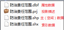
解析.shp.dbf文件
package com.kero99.utils;

import java.io.File;
import java.io.StringWriter;
import java.nio.charset.Charset;
import java.util.ArrayList;
import java.util.HashMap;
import java.util.LinkedHashMap;
import java.util.List;
import java.util.Map;

import org.geotools.data.shapefile.ShapefileDataStore;
import org.geotools.data.shapefile.ShapefileDataStoreFactory;
import org.geotools.data.shapefile.dbf.DbaseFileHeader;
import org.geotools.data.shapefile.dbf.DbaseFileReader;
import org.geotools.data.shapefile.files.ShpFiles;
import org.geotools.data.simple.SimpleFeatureCollection;
import org.geotools.data.simple.SimpleFeatureIterator;
import org.geotools.data.simple.SimpleFeatureSource;
import org.geotools.geojson.feature.FeatureJSON;
import org.geotools.geojson.geom.GeometryJSON;
import org.opengis.feature.simple.SimpleFeature;
import org.opengis.feature.type.AttributeDescriptor;

import net.sf.json.JSONArray;
import net.sf.json.JSONObject;

public class ShapeUtils {
	 /**
	  * 解析.shp 点线面文件
	  * @param path
	  * @return
	  * @throws Exception
	  * @author ygc
	  */
	 public static Map<String, String> ParasShapeFileData(String path) throws Exception {
			Map<String, String> map = new HashMap<String, String>();
			try {

				File file = new File(path);
				String fileName = file.getName();
				ShapefileDataStoreFactory sfdsf = new ShapefileDataStoreFactory();
				ShapefileDataStore sfds = (ShapefileDataStore) sfdsf.createDataStore(file.toURI().toURL());

				sfds.setCharset(Charset.forName("GBK"));
				SimpleFeatureSource featureSource = sfds.getFeatureSource();

				List<AttributeDescriptor> attrList = sfds.getSchema().getAttributeDescriptors();
				JSONObject pFieldJSON = new JSONObject();
				for (AttributeDescriptor attributeDescriptor : attrList) {
					String pFieldName = attributeDescriptor.getName().toString();
					String pTypeName = attributeDescriptor.getType().getBinding().getSimpleName();
	//				System.out.println(attributeDescriptor.getType().getBinding().getName());
					if (pFieldName == "the_geom") {
						map.put("type", pTypeName);
						pFieldName = "Shape";
						pTypeName = "Geometry";
					}

					pFieldJSON.put(pFieldName, getShapeType(pTypeName));

				}
				// System.out.println(pFieldJSON);
				SimpleFeatureCollection feacollection = featureSource.getFeatures();

				SimpleFeatureIterator iterator = feacollection.features();
				GeometryJSON gjson = new GeometryJSON(15);
				FeatureJSON fjson = new FeatureJSON(gjson);

				StringWriter writer = new StringWriter();
				while (iterator.hasNext()) {
					SimpleFeature sFeature = iterator.next();
					if (writer.toString().isEmpty()) {
						fjson.writeFeature(sFeature, writer);
					} else {
						writer.write(',');
						fjson.writeFeature(sFeature, writer);
					}
				}
				iterator.close();
				writer.flush();
				writer.close();
				sfds.dispose();

				String jsonData = "[" + writer.toString() + "]";
				// System.err.println(jsonData);

				JSONObject jsonObject = new JSONObject();
				jsonObject.put("type", "FeatureCollection");
				jsonObject.put("features", JSONArray.fromObject(jsonData));
				map.put("features", jsonObject.toString());
				map.put("fields", pFieldJSON.toString());

				map.put("LayerName", file.getName().replace(".shp", ""));

				map.put("op", "sucess");

				// System.out.println(map);
			} catch (Exception e) {
				// TODO: handle exception
				e.printStackTrace();
				map.put("op", "fail");
			}

			return map;
		}
	 	/**
		  * 解析.dbf
		  * @param path
		  * @return
		  * @throws Exception
		  * @author ygc
		  */
	 public static  List<Object> readDbfFile(String path){
		 List<Object> list=new ArrayList<Object>();
		 Map<Object, Object> values = null;
		 DbaseFileReader reader = null;
		    try {
		        reader = new DbaseFileReader(new ShpFiles(path), false, Charset.forName("GBK"));
		        DbaseFileHeader header = reader.getHeader();
		        int numFields = header.getNumFields();
		        //迭代读取记录
		        while (reader.hasNext()) {
		            try {
		                Object[] entry = reader.readEntry();
		                values=new LinkedHashMap<Object, Object>();
		                for (int i=0; i<numFields; i++) {
		                    String title = header.getFieldName(i);
		                    Object value = entry[i];
		                    values.put(title, value);
		                    System.out.println(title+"="+value);
		                }

		            } catch (Exception e) {
		                e.printStackTrace();
		            }
		            list.add(values);
		        }
		    } catch (Exception e) {
		        e.printStackTrace();
		    } finally {
		        if (reader != null) {
		            //关闭
		            try {reader.close();} catch (Exception e) {}
		        }
		    }
			return list;
	 }
	 public static String getShapeType(String type) {
			String pDbFieldType = "";
			switch (type) {
			case "Integer":
				pDbFieldType = "INTEGER";
				break;
			case "Double":
				pDbFieldType = "DOUBLE";
				break;
			case "String":
				pDbFieldType = "VARCHAR";
				break;
			case "Date":
				pDbFieldType = "DATETIME";
				break;
			case "Boolean":
				pDbFieldType = "BOOLEAN";
				break;
			case "Geometry":
				pDbFieldType = "Geometry";
				break;
			default:
				pDbFieldType = "TEXT";
				break;
			}
			return pDbFieldType;
		}
	 //投影转换 prj
	 public static void main(String[] args) throws Exception {
		 String path="E:\\shape文件\\设计图斑\\设计图斑-线状\\设计图斑-线状.dbf";
		 ShapeUtils.readDbfFile(path);
		 System.out.println(ShapeUtils.ParasShapeFileData(path));
	}
}


 3537
3537


 被折叠的 条评论
为什么被折叠?
被折叠的 条评论
为什么被折叠?
 到【灌水乐园】发言


