


随着使用GPS坐标位置的手机或者设备越来越多,越来越多的应用使用gps坐标位置,为此redis增加了一种新的结构geo,可以很方便的计算最近距离的点。
首先添加pom.xml的jar包依赖
<dependencies>
        <dependency>
            <groupId>org.springframework.boot</groupId>
            <artifactId>spring-boot-starter</artifactId>
        </dependency>

        <dependency>
            <groupId>org.springframework.boot</groupId>
            <artifactId>spring-boot-starter-web</artifactId>
        </dependency>
        <dependency>
            <!-- redis -->
            <groupId>org.springframework.boot</groupId>
            <artifactId>spring-boot-starter-data-redis</artifactId>
        </dependency>
        <dependencies>
            <dependency>
                <groupId>org.projectlombok</groupId>
                <artifactId>lombok</artifactId>
                <version>1.16.16</version>
                <scope>provided</scope>
            </dependency>
        </dependencies>

        <dependency>
            <groupId>org.springframework.boot</groupId>
            <artifactId>spring-boot-starter-test</artifactId>
            <scope>test</scope>
        </dependency>
        <dependency>
            <groupId>org.projectlombok</groupId>
            <artifactId>lombok</artifactId>
        </dependency>
    </dependencies>
2、做一个添加坐标点,一个查询附近坐标点的查询方法
@RestController
@RequestMapping("redisGeo")
public class RedisGeoController {

    @Autowired
    private RedisGeoService redisGeoService;

    private final String GEO_KEY="geo_key";

    /**
     * 使用redis+geo 上传位置
     * @param cityId
     * @param driverId
     * @param lng
     * @param lat
     * @return
     */
    @PostMapping("addDriverPosition")
    public  Long addDriverPosition(String cityId,String driverId,Double lng,Double lat){
        String redisKey= CommonUtil.buildRedisKey(GEO_KEY,cityId);
        long addnum=redisGeoService.geoAdd(redisKey,new Point(lng,lat),driverId);
        List<Point> points=redisGeoService.geoGet(redisKey,driverId);
        System.out.println("添加坐标点的位置"+points);
        return  addnum;
    }

    /**
     * 使用reidis+geo 查找附近司机位置
     * @param cityId
     * @param lng
     * @param lat
     * @return
     */

    @GetMapping("getNearDrivers")
    public List<DriverPosition> getNearDrivers(String cityId,Double lng,Double lat){
        String redisKey=CommonUtil.buildRedisKey(GEO_KEY,cityId);
        Circle circle=new Circle(lng,lat, Metrics.KILOMETERS.getMultiplier());
        GeoResults<RedisGeoCommands.GeoLocation<String>> results=redisGeoService.nearByXY(redisKey,circle,5);
        System.out.println("查询附近司机位置"+results);

        List<DriverPosition> list =new ArrayList<>();
        results.forEach(item->{
            RedisGeoCommands.GeoLocation<String> location=item.getContent();
            Point point=location.getPoint();
            DriverPosition position=DriverPosition.builder().cityCode(cityId).driverId(location.getName()).lng(point.getX()).lat(point.getY()).build();
            list.add(position);
        });
        return  list;
    }


}
3、添加bean DriverPosition
import lombok.*;

@Getter
@Setter
@Builder
@NoArgsConstructor
@AllArgsConstructor
public class DriverPosition {
    private String driverId;
    private  String cityCode;
    private  double lng;
    private  double lat;
}
4、添加geo的service方法
import lombok.extern.slf4j.Slf4j;
import org.springframework.beans.factory.annotation.Autowired;
import org.springframework.data.geo.*;
import org.springframework.data.redis.connection.RedisGeoCommands;
import org.springframework.data.redis.core.StringRedisTemplate;
import org.springframework.stereotype.Service;

import java.util.List;

@Service
@Slf4j
public class RedisGeoService {

    @Autowired
    private StringRedisTemplate  redisTemplate;

    /**
     * 添加经纬度信息
     * redis 命令; geoadd key 120.223213 39.123123 "上海"
     * @param key
     * @param point
     * @param member
     * @return
     */
    public Long geoAdd(String key, Point point, String member){
        log.info((redisTemplate==null)+"=====");
        if(redisTemplate.hasKey(key)){
            redisTemplate.opsForGeo().remove(key,member);
        }
        return redisTemplate.opsForGeo().add(key,point,member);
    }

    /**
     * 根据key members批量获取坐标点
     *
     * redis 命令: geopos key 上海
     * @param key
     * @param members
     * @return
     */
    public List<Point> geoGet(String key, String... members){
        return redisTemplate.opsForGeo().position(key,members);
    }

    /**
     * 返回两个地方的距离,可以指定单位,比如:米m千米km,英里mi 英尺ft
     * redis 命令 : deodist key 北京 上海
     * @param key
     * @param member1
     * @param member2
     * @param metric
     * @return
     */
    public Distance geoDist(String key, String member1, String member2, Metric metric){
        return redisTemplate.opsForGeo().distance(key, member1, member2, metric);
    }

    /**
     * 根据给定的经纬度,返回半径不超过指定距离的元素
     *
     * redis命令 georedius key 116.2323 39.123123123 100 Km WITHDIST WITHCOORDASC COUNT 5
     * @param key
     * @param circle
     * @param count
     * @return
     */
    public GeoResults<RedisGeoCommands.GeoLocation<String>> nearByXY(String key, Circle circle, long count){
        // includeDIstance 包含距离
        // includeCoordinates 包含经纬度
        // sortAscending 正序排序
        // limit 限定返回的记录数
        RedisGeoCommands.GeoRadiusCommandArgs args=RedisGeoCommands.GeoRadiusCommandArgs.newGeoRadiusArgs().includeDistance().includeCoordinates().sortAscending().limit(count);
        return  redisTemplate.opsForGeo().radius(key, circle, args);
    }

    /**
     * 根据指定的地点查询半径在指定范围内的位置
     *
     * redis命令 : georadiusbymember key 北京 100 Km WITHDIST WITHCOORD ASC COUNT 5
     * @param key
     * @param member
     * @param distance
     * @param count
     * @return
     */
    public GeoResults<RedisGeoCommands.GeoLocation<String>> nearByPlace(String key,String member,Distance distance,long count){
        //includeDistance 包含距离
        //includeCoordinates 包含经纬度
        //sortAscending 正序排序
        //limit 限定返回的记录数
        RedisGeoCommands.GeoRadiusCommandArgs args=RedisGeoCommands.GeoRadiusCommandArgs.newGeoRadiusArgs().includeDistance().includeCoordinates().sortAscending().limit(count);
        return  redisTemplate.opsForGeo().radius(key,member,distance,args);
    }

    /**
     * 返回 geohash值
     * redis命令: geohash key 北京
     * @param key
     * @param member
     * @return
     */
    public  List<String> geoHash(String key,String member){
        return redisTemplate.opsForGeo().hash(key,member);
    }
}
5、添加application.yml文件
spring:
  redis:
    host: 127.0.0.1
    port: 6379
#    password: redis2020
    database: 1
第二部分:测试
1、使用postman调用增加坐标的方法
http://localhost:8080/redisGeo/addDriverPosition?cityId=420000&driverId=000001&lng=114.366386&lat=30.408199
http://localhost:8080/redisGeo/addDriverPosition?cityId=420000&driverId=000002&lng=114.365281&lat=30.406869
http://localhost:8080/redisGeo/addDriverPosition?cityId=420000&driverId=000003&lng=114.368049&lat=30.412896
http://localhost:8080/redisGeo/addDriverPosition?cityId=420000&driverId=000004&lng=114.365248&lat=30.537860
2.查看redis存的值
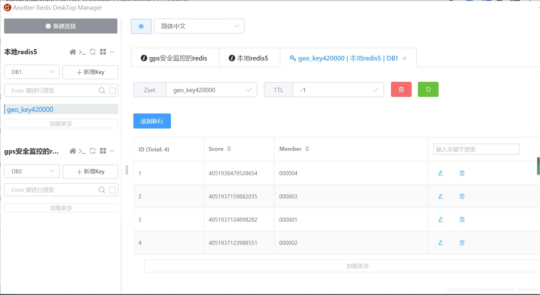
注意:如果调用redis遇到
io.lettuce.core.RedisCommandExecutionException: ERR unknown command 'GEOADD'
错误,说明自己windows版本的redis版本太低,需要下载更新版本的redis,大家可以下载redis4或者redis5的版本,下载地址:
https://github.com/tporadowski/redis/releases
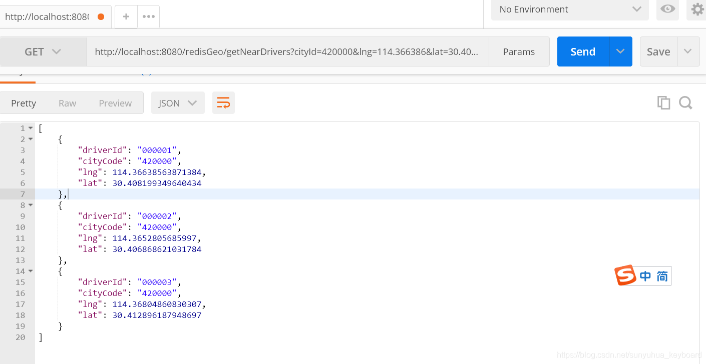
3、调用查看附近坐标点的接口,查看是不是距离最近的坐标
参考文章:https://www.cnblogs.com/xuwenjin/p/12715339.html
完整的工程代码:
https://github.com/sunyuhuakeyboard/georedisdemo


 238
238


 被折叠的 条评论
为什么被折叠?
被折叠的 条评论
为什么被折叠?
 到【灌水乐园】发言


