import math
defgcj02_to_wgs84(lon, lat):"""
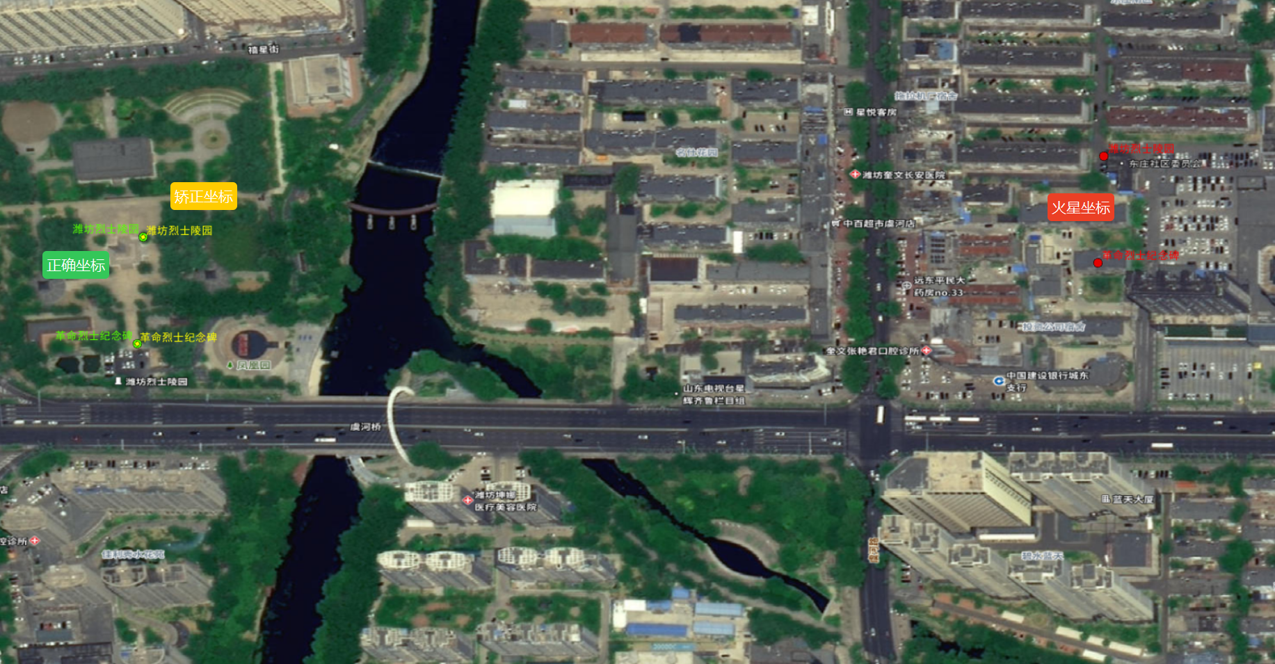
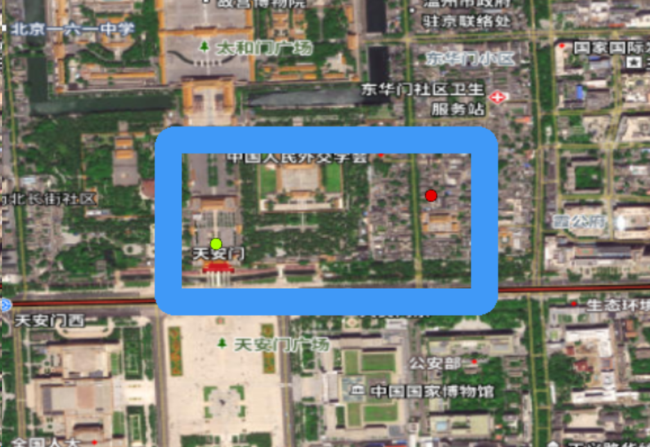
高德火星坐标(GCJ-02)转WGS84坐标
"""
a =6378245.0# 长半轴
ee =0.00669342162296594323# 扁率deftransform_lon(x, y):
ret =300.0+ x +2.0* y +0.1* x * x +0.1* x * y +0.1* math.sqrt(abs(x))
ret +=(20.0* math.sin(6.0* x * math.pi)+20.0* math.sin(2.0* x * math.pi))*2.0/3.0
ret +=(20.0* math.sin(x * math.pi)+40.0* math.sin(x /3.0* math.pi))*2.0/3.0
ret +=(150.0* math.sin(x /12.0* math.pi)+300.0* math.sin(x /30.0* math.pi))*2.0/3.0return ret
deftransform_lat(x, y):
ret =-100.0+2.0* x +3.0* y +0.2* y * y +0.1* x * y +0.2* math.sqrt(abs(x))
ret +=(20.0* math.sin(6.0* x * math.pi)+20.0* math.sin(2.0* x * math.pi))*2.0/3.0
ret +=(20.0* math.sin(y * math.pi)+40.0* math.sin(y /3.0* math.pi))*2.0/3.0
ret +=(160.0* math.sin(y /12.0* math.pi)+320* math.sin(y * math.pi /30.0))*2.0/3.0return ret
dlat = transform_lat(lon -105.0, lat -35.0)
dlon = transform_lon(lon -105.0, lat -35.0)
radlat = lat /180.0* math.pi
magic = math.sin(radlat)
magic =1- ee * magic * magic
sqrtmagic = math.sqrt(magic)
dlat =(dlat *180.0)/((a *(1- ee))/(magic * sqrtmagic)* math.pi)
dlon =(dlon *180.0)/(a / sqrtmagic * math.cos(radlat)* math.pi)
wgs_lat = lat - dlat
wgs_lon = lon - dlon
return wgs_lon, wgs_lat
2 使用Arcpy实现点要素类坐标转换
import arcpy
import math
defgcj02_to_wgs84(lon, lat):"""
高德火星坐标(GCJ-02)转WGS84坐标
"""
a =6378245.0# 长半轴
ee =0.00669342162296594323# 扁率deftransform_lon(x, y):
ret =300.0+ x +2.0* y +0.1* x * x +0.1* x * y +0.1* math.sqrt(abs(x))
ret +=(20.0* math.sin(6.0* x * math.pi)+20.0* math.sin(2.0* x * math.pi))*2.0/3.0
ret +=(20.0* math.sin(x * math.pi)+40.0* math.sin(x /3.0* math.pi))*2.0/3.0
ret +=(150.0* math.sin(x /12.0* math.pi)+300.0* math.sin(x /30.0* math.pi))*2.0/3.0return ret
deftransform_lat(x, y):
ret =-100.0+2.0* x +3.0* y +0.2* y * y +0.1* x * y +0.2* math.sqrt(abs(x))
ret +=(20.0* math.sin(6.0* x * math.pi)+20.0* math.sin(2.0* x * math.pi))*2.0/3.0
ret +=(20.0* math.sin(y * math.pi)+40.0* math.sin(y /3.0* math.pi))*2.0/3.0
ret +=(160.0* math.sin(y /12.0* math.pi)+320* math.sin(y * math.pi /30.0))*2.0/3.0return ret
dlat = transform_lat(lon -105.0, lat -35.0)
dlon = transform_lon(lon -105.0, lat -35.0)
radlat = lat /180.0* math.pi
magic = math.sin(radlat)
magic =1- ee * magic * magic
sqrtmagic = math.sqrt(magic)
dlat =(dlat *180.0)/((a *(1- ee))/(magic * sqrtmagic)* math.pi)
dlon =(dlon *180.0)/(a / sqrtmagic * math.cos(radlat)* math.pi)
wgs_lat = lat - dlat
wgs_lon = lon - dlon
return wgs_lon, wgs_lat
# 输入参数设置
input_fc =r"Point"# 替换为你的输入要素类路径
output_fc =r"Point2"# 替换为你的输出要素类路径
output_sr = arcpy.SpatialReference(4490)# CGCS2000地理坐标系
ws =r"D:\admin\Documents\Projects\tj\tj.gdb"
arcpy.env.workspace = ws
# 创建输出要素类
arcpy.management.CreateFeatureclass(
out_path=arcpy.env.workspace,
out_name=output_fc,
geometry_type="POINT",
spatial_reference=output_sr
)# 添加字段(根据输入要素字段需要调整)
arcpy.management.AddField(output_fc,"NAME","TEXT")# 开始编辑with arcpy.da.Editor(arcpy.env.workspace)as edit:# 使用插入游标写入新要素with arcpy.da.InsertCursor(output_fc,["SHAPE@","NAME"])as insert_cursor:# 使用搜索游标读取原始要素with arcpy.da.SearchCursor(input_fc,["SHAPE@","NAME"])as cursor:for row in cursor:# 获取原始坐标(假设输入是点要素)
original_point = row[0]
x = original_point.firstPoint.X
y = original_point.firstPoint.Y
# 执行坐标转换
converted_x, converted_y = gcj02_to_wgs84(x, y)# 创建新点对象
new_point = arcpy.Point(converted_x, converted_y)
new_geometry = arcpy.PointGeometry(new_point, output_sr)# 写入新要素
insert_cursor.insertRow([new_geometry, row[1]])print("坐标转换完成!")
ut_sr)# 写入新要素
insert_cursor.insertRow([new_geometry, row[1]])print("坐标转换完成!")


 2973
2973

 被折叠的 条评论
为什么被折叠?
被折叠的 条评论
为什么被折叠?
 到【灌水乐园】发言


