


1. geojson配置后效果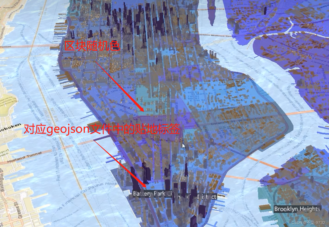
1. 数据文件加载的时候会遇到的情况:
① Blocked script execution in ‘about:blank’ because the document’s frame is sandboxed and the ‘allow-scripts’ permission is not set.
上面这个问题是由于cesium的沙盒配置不兼容导致的,解决方案:
方案1  配置沙盒中的属性
  var iframe = document.getElementsByClassName("cesium-infoBox-iframe")[0];

  iframe.setAttribute(
    "sandbox",
    "allow-same-origin allow-scripts allow-popups allow-forms"
  );
  iframe.setAttribute("src", ""); //必须设置src为空 否则不会生效
方案2  关闭试图中的沙盒
  let viewer = new Cesium.Viewer("cesiumContainer", {
    //cesium的查看器的基本属性
    baseLayerPicker: true, //配置图层底图的图标
    // imageryProvider:custom  ,//使用上面自己配置的底图
    terrainProvider: Cesium.createWorldTerrain({
      //设置cesium的世界地形
      requestVertexNormals: true, //地形的开启
      requestWaterMask: true, //水面效果的开启
      infoBox:false,   在这里关闭沙盒
    }),
  });
② GET http://127.0.0.1:5173/assets/simplestyles.geojson 404 (Not Found)
无法找到自己的文件 ,解决方案:将自己的geojson文件移动到public下
2. 加载自己的geojson并且配置加载完成后的地形区块完整功能块 带标签属性设置
// geojson文件加载
  let neighborHoodsPromise = Cesium.GeoJsonDataSource.load(
    "./assets/sampleNeighborhoods.geojson"
  );
  console.log("读取到的文件数据是:", neighborHoodsPromise);
  let neighborhoods;
  neighborHoodsPromise
    .then((dataSource) => {
      console.log(".then的结果是:", dataSource);
      // 将数据放置到查看器中
      neighborhoods = dataSource.entities;
      let neighborhoodsEntities = dataSource.entities.values;
      for (let i = 0; i < neighborhoodsEntities.length; i++) {
        let entity = neighborhoodsEntities[i];
        console.log("得到的对象是entity:", entity);
        if (Cesium.defined(entity.polygon)) {
          //判断当前的对象是否存在
          entity.name = entity.properties.neighborhood;
          // 多边形材质的设定
          entity.polygon.material = Cesium.Color.fromRandom({
            //设置随机颜色
            red: 0.1,
            maximumGreen: 0.5,
            minimumBlue: 0.5,
            alpha: 0.6, //透明度
          });
          // 多边形地形着色的操作
          entity.polygon.classificationType = Cesium.ClassificationType.TERRAIN;
          //获取具体的时间和位置信息
          let polyPositions = entity.polygon.hierarchy.getValue(
            Cesium.JulianDate.now()
          ).positions;
          //设置中心点  贴到地形的表面
          let polyCenter =
            Cesium.BoundingSphere.fromPoints(polyPositions).center;
          polyCenter =
            Cesium.Ellipsoid.WGS84.scaleToGeocentricSurface(polyCenter);
          entity.position = polyCenter;

          //生成标签
          entity.label = {
            text: entity.name,
            showBackground: true, //显示背景颜色
            scale: 0.6, //设置缩放比例
            horizontalOrigin: Cesium.HorizontalOrigin.center, //显示的位置
            verticalOrigin: Cesium.VerticalOrigin.BOTTOM, //垂直原点贴近地表
            distanceDisplayCondition: new Cesium.DistanceDisplayCondition(
              10,
              8000
            ), //设置展示范围   高度在10-8000的时候显示标签
            disableDepthTestDistance: 100, //太远的时候标签不能点
          };
        }
      }
    })
    .catch((e) => {});
3. 单页面完整代码
<template>
  <div id="cesiumContainer"></div>
</template>

<script setup>
import * as Cesium from "cesium";
import { onMounted } from "vue";
onMounted(() => {
  // 配置cesium中的相关属性
  // let custom = new Cesium.ArcGisMapServerImageryProvider({
  //   url: "//servicse.arcgisonline.com/ArcGIS/rest/services/World_Street_Map/MapServer",
  // });
  let viewer = new Cesium.Viewer("cesiumContainer", {
    //cesium的查看器的基本属性
    baseLayerPicker: true, //配置图层底图的图标
    // imageryProvider:custom  ,//使用上面自己配置的底图
    terrainProvider: Cesium.createWorldTerrain({
      //设置cesium的世界地形
      requestVertexNormals: true, //地形的开启
      requestWaterMask: true, //水面效果的开启
      // infoBox:false,
    }),
  });
  // 设置默认相机视角
  // viewer.camera.setView({
  //   destination: Cesium.Cartesian3.fromDegrees(113.318977, 23.114155, 2000),//广州坐标
  //   // 方向,俯视和仰视的视角
  //   orientation: {
  //     heading: Cesium.Math.toRadians(90), //坐标系旋转90度
  //     pitch: Cesium.Math.toRadians(-45), //设置俯仰角度为-45度
  //   },
  // });
  // 设置默认相机视角
  viewer.camera.setView({
    destination: new Cesium.Cartesian3(1332761, -4662399, 4137888), //纽约的地理坐标
    orientation: {
      heading: 0.6,
      pitch: -0.66,
      // pitch: Cesium.Math.toRadians(-90), //设置俯仰角度为-45度
    },
  });

  let city = viewer.scene.primitives.add(
    new Cesium.Cesium3DTileset({ url: Cesium.IonResource.fromAssetId(75343) })
  );

  // 定义3d样式
  let heightStyle = new Cesium.Cesium3DTileStyle({
    color: {
      // 条件判断建筑物的颜色
      conditions: [
        ["${Height} >= 300", "rgba(45,0,75,0.5)"],
        ["${Height}>=200", "rgb(102,71,151)"],
        ["${Height}>=100", "rgba(170,162,204,0.5)"],
        ["${Height}>=50", "rgb(224,226,238)"],
        ["${Height}>=25", "rgb(252,230,200)"],
        ["${Height}>=10", "rgba(248,176,87,0.5)"],
        ["${Height}>=5", "rgb(198,106,11)"],
        ["true", "rgb(127,59,8)"],
      ],
    },
  });

  city.style = heightStyle;

  // viewer.dataSources.add(
  //   Cesium.GeoJsonDataSource.load("./assets/sampleNeighborhoods.geojson")
  // );

  // geojson文件加载
  let neighborHoodsPromise = Cesium.GeoJsonDataSource.load(
    // "../public/mock/sampleNeighborhoods.geojson"
    "./assets/simplestyles.geojson"
  );
  let neighborhoods;
  // var iframe = document.getElementsByClassName("cesium-infoBox-iframe")[0];

  // iframe.setAttribute(
  //   "sandbox",
  //   "allow-same-origin allow-scripts allow-popups allow-forms"
  // );
  var iframe = document.getElementsByClassName("cesium-infoBox-iframe")[0];

  iframe.setAttribute(
    "sandbox",
    "allow-same-origin allow-scripts allow-popups allow-forms"
  );
  iframe.setAttribute("src", ""); //必须设置src为空 否则不会生效

  console.log("读取到的文件数据是:", neighborHoodsPromise);
  neighborHoodsPromise
    .then((dataSource) => {
      console.log(".then的结果是:", dataSource);
      // 将数据放置到查看器中
      neighborhoods = dataSource.entities;
      let neighborhoodsEntities = dataSource.entities.values;
      for (let i = 0; i < neighborhoodsEntities.length; i++) {
        let entity = neighborhoodsEntities[i];
        console.log("得到的对象是entity:", entity);
        if (Cesium.defined(entity.polygon)) {
          //判断当前的对象是否存在
          entity.name = entity.properties.neighborhood;
          // 多边形材质的设定
          entity.polygon.material = Cesium.Color.fromRandom({
            //设置随机颜色
            red: 0.1,
            maximumGreen: 0.5,
            minimumBlue: 0.5,
            alpha: 0.6, //透明度
          });
          // 多边形地形着色的操作
          entity.polygon.classificationType = Cesium.ClassificationType.TERRAIN;
          //获取具体的时间和位置信息
          let polyPositions = entity.polygon.hierarchy.getValue(
            Cesium.JulianDate.now()
          ).positions;
          //设置中心点  贴到地形的表面
          let polyCenter =
            Cesium.BoundingSphere.fromPoints(polyPositions).center;
          polyCenter =
            Cesium.Ellipsoid.WGS84.scaleToGeocentricSurface(polyCenter);
          entity.position = polyCenter;

          //生成标签
          entity.label = {
            text: entity.name,
            showBackground: true, //显示背景颜色
            scale: 0.6, //设置缩放比例
            horizontalOrigin: Cesium.HorizontalOrigin.center, //显示的位置
            verticalOrigin: Cesium.VerticalOrigin.BOTTOM, //垂直原点贴近地表
            distanceDisplayCondition: new Cesium.DistanceDisplayCondition(
              10,
              8000
            ), //设置展示范围   高度在10-8000的时候显示标签
            disableDepthTestDistance: 100, //太远的时候标签不能点
          };
        }
      }
    })
    .catch((e) => {});
});
</script>

<style scoped>
#cesiumContainer {
  width: 100% !important;
  height: 100% !important;
  margin: 0 !important;
  padding: 0 !important;
  overflow: hidden;
  position: absolute;
}
</style>


 2882
2882


 被折叠的 条评论
为什么被折叠?
被折叠的 条评论
为什么被折叠?
 到【灌水乐园】发言


