


 本文详细介绍了如何使用Python编程从NASA的MODIS数据获取模块下载HDF文件,包括设置Cookies、数据处理(如读取HDF属性、转HDF为TIFF并进行拼接和投影变换),以及如何使用GDAL库进行空间参考和重采样操作。
一、数据选取
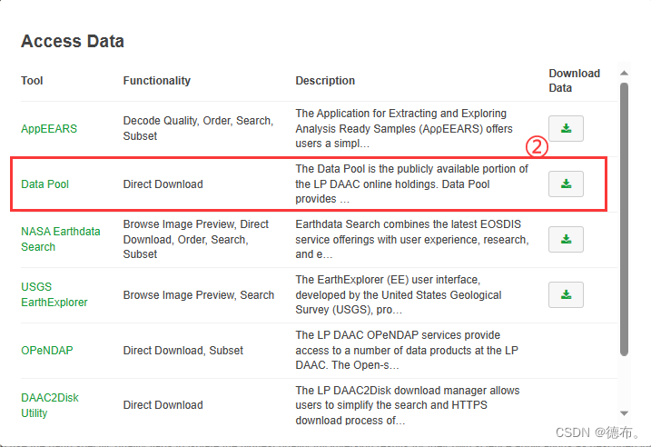
以MODIS/061/MCD43A4为例: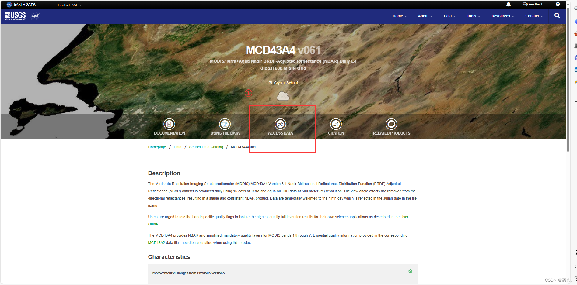

二、数据获取Python代码:
2.1 获取Cookies
谷歌浏览器登陆:https://urs.earthdata.nasa.gov/profile
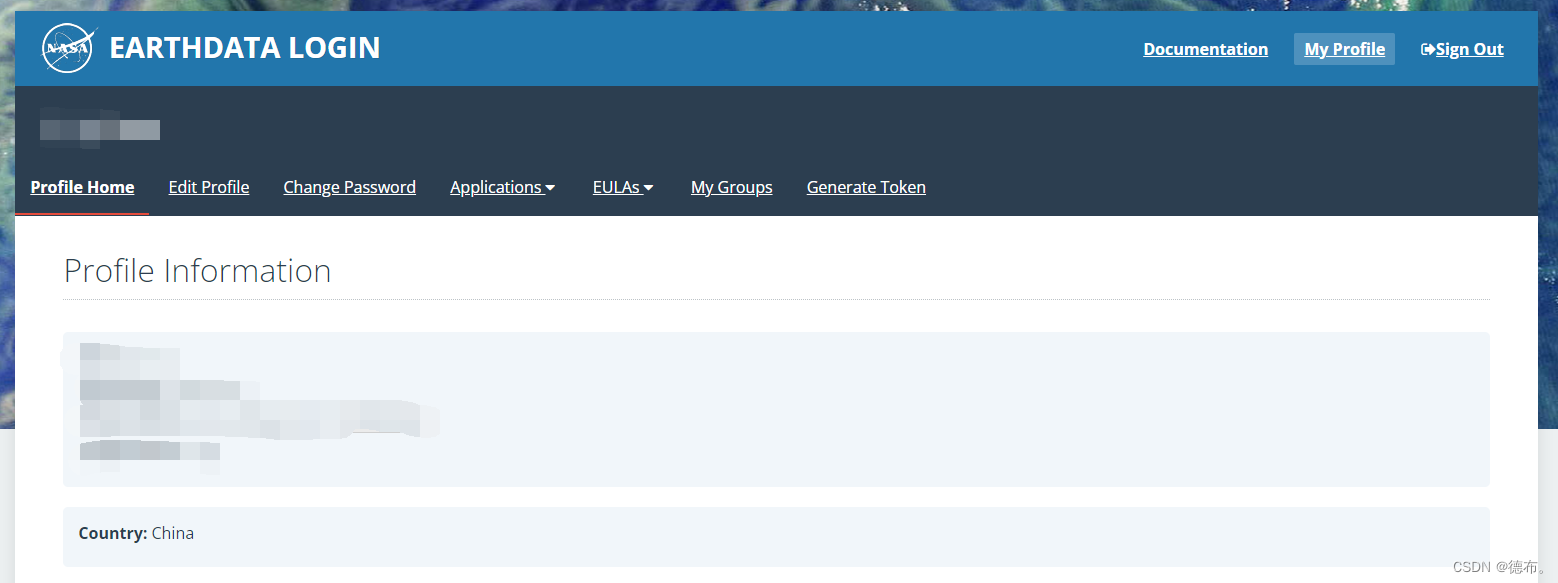
按F12打开浏览器控制台,复制对应的Value

2.2 Python代码
import os
from datetime import datetime
from multiprocessing import Pool
import pandas as pd
import requests
from bs4 import BeautifulSoup

def main(SUB_URL):
    # 下载到哪个文件夹
    dst_folder = "F:\\2012_Python"

    # 创建目录
    os.makedirs(dst_folder, exist_ok=True)

    # 请求链接
    r_subfolder = requests.get(SUB_URL)
    soup_subfolder = BeautifulSoup(r_subfolder.text, "html.parser")

    # 遍历所有链接
    for link_carpetas in soup_subfolder.find_all("a"):
        file_name = link_carpetas.get("href")
        # 如果是HDF文件
        if file_name.endswith('.hdf'):
            remote_file = SUB_URL + "/" + file_name
            dst_file = os.path.join(dst_folder, file_name)

            # # 判断是否已下载
            # if os.path.exists(dst_file) and os.path.getsize(dst_file) > 2048:
            #     continue

            print(remote_file)

            # cookies信息
            cookies = {'_urs-gui_session': 'XXXXXXX'} #获取的Cookies,cookies _urs-gui_session 需要修改,有效期一般只有1天
            requests.DEFAULT_RETRIES = 5

            response = requests.get(remote_file, cookies=cookies, timeout=300)

            with open(dst_file, "wb") as handle:
                handle.write(response.content)
                print("download_success", dst_file)

if __name__ == '__main__':
    # 影像的起始和截止时间
    time_series = pd.date_range(start=datetime.strptime("2012-01-01", '%Y-%m-%d'),
                                end=datetime.strptime("2013-01-01", '%Y-%m-%d'), freq='d').to_list()

    # 影像的下载地址,上图复制的链接
    url_list = ["https://e4ftl01.cr.usgs.gov/MOTA/MCD43A4.061/" + datetime.strftime(t, '%Y.%m.%d') for t in time_series]

    pool = Pool(20)  # 设置并行处理的线程数
    pool.map(main, url_list)
三、数据处理python代码
3.1 读取HDF文件信息
列出HDF文件中所有数据集和文件级别的属性名及其对应的值,特别注意识别包含空间范围信息的属性。
from pyhdf.SD import SD, SDC

def list_hdf_attributes(hdf_file):
    """列出HDF文件中的所有属性。"""
    file = SD(hdf_file, SDC.READ)

    # 打印文件级别的属性
    print("File-level attributes:")
    for name in file.attributes().keys():
        value = file.attributes()[name]
        print(f"  {name}: {value}")

    # 打印每个数据集的属性
    datasets_dic = file.datasets()
    for ds_name in datasets_dic.keys():
        print(f"\nDataset: {ds_name}")
        sds = file.select(ds_name)
        for name in sds.attributes().keys():
            value = sds.attributes()[name]
            print(f"  {name}: {value}")

    file.end()  # 关闭文件

# HDF文件路径
hdf_file_path = 'hdf_file.hdf'  #替换为HDF文件的实际路径

# 列出属性
list_hdf_attributes(hdf_file_path)
- 获取到的空间信息如下:
以下信息包含在StructMetadata.0中:
GridName=“MOD_Grid_BRDF”
XDim=2400
YDim=2400
UpperLeftPointMtrs=(4447802.078667,-2223901.039333)
LowerRightMtrs=(5559752.598333,-3335851.559000)
Projection=GCTP_SNSOID 【正弦投影Sinusoidal projection】
ProjParams=(6371007.181000,0,0,0,0,0,0,0,0,0,0,0,0) 【投影设置的必要参数:地球半径m】
- 获取到数据集"Nadir_Reflectance_Band1"的信息如下,其他波段类似:
Dataset: Nadir_Reflectance_Band1
long_name: Nadir_Reflectance_Band1
> units: reflectance, no units
valid_range: [0, 32766]
> _FillValue:32767
> scale_factor: 0.0001
add_offset: 0.0
scale_factor_err: 0.0
add_offset_err: 0.0
calibrated_nt: 5
3.2 转换单个HDF to TIFF
# -*- coding: utf-8 -*-
from pyhdf.SD import SD, SDC
from osgeo import gdal, osr
import os


def get_spatial_extent(hdf_file):
    """从HDF文件中读取空间范围信息。"""
    file = SD(hdf_file, SDC.READ)

    # 从文件属性中提取空间范围信息
    # 3.1过程中获取得到
    attrs = file.attributes()
    struct_metadata = attrs['StructMetadata.0']

    # 解析StructMetadata获取空间范围信息
    parts = struct_metadata.split('\n')
    upper_left = None
    lower_right = None
    for part in parts:
        if "UpperLeftPointMtrs" in part:
            upper_left = tuple(map(float, part.split('=')[1].strip('()').split(',')))
        elif "LowerRightMtrs" in part:
            lower_right = tuple(map(float, part.split('=')[1].strip('()').split(',')))

    file.end()  # 关闭文件
    return upper_left, lower_right


def convert_hdf_to_tiff(hdf_file, output_folder):
    """将 HDF 文件中的多个波段转换为 TIFF 格式,并设置地理参考。"""
    hdf = SD(hdf_file, SDC.READ)

    # 选择一个波段来获取尺寸
    sds_obj = hdf.select('Nadir_Reflectance_Band1')
    band_dims = sds_obj.dimensions()

    # 列出所有维度
    print("Dimensions in the dataset:", band_dims)

    # 根据实际的维度名称获取列数和行数
    cols = band_dims['YDim:MOD_Grid_BRDF']
    rows = band_dims['XDim:MOD_Grid_BRDF']

    # 获取空间范围信息
    upper_left, lower_right = get_spatial_extent(hdf_file)

    # 设置GeoTransform参数
    pixel_width = (lower_right[0] - upper_left[0]) / cols
    pixel_height = (lower_right[1] - upper_left[1]) / rows

    geotransform = (upper_left[0], pixel_width, 0, upper_left[1], 0, pixel_height)

    # 设置空间参考
    sr = osr.SpatialReference()
    sr.ImportFromProj4('+proj=sinu +R=6371007.181 +nadgrids=@null +wktext') # 设置正弦投影和相关参数
    spatial_ref = sr.ExportToWkt()

    # 转换每个波段为TIFF
    for idx in range(1, 8):
        band_name = f'Nadir_Reflectance_Band{idx}'
        sds_obj = hdf.select(band_name)
        band_data = sds_obj.get()

        output_filename = os.path.join(output_folder, f'{band_name}.tif')
        driver = gdal.GetDriverByName("GTiff")
        dataset = driver.Create(output_filename, cols, rows, 1, gdal.GDT_Int16, ["TILED=YES", "COMPRESS=LZW"])

        dataset.SetGeoTransform(geotransform)
        dataset.SetProjection(spatial_ref)
        dataset.GetRasterBand(1).WriteArray(band_data)

        dataset = None  # 关闭文件


# HDF 文件和输出文件夹的路径
hdf_file_path = 'F:\XX.hdf' #替换为HDF文件的实际路径
output_folder = 'F:\XXXX'   #替换为保存TIFF文件夹的实际路径


# 调用函数进行转换
convert_hdf_to_tiff(hdf_file_path, output_folder)
3.3 对TIFF文件进行拼接、投影变换和重采样
import arcpy
import os

def process_tiff_in_subfolders(input_root_folder, output_root_folder, inf):
    # 重采样参考栅格文件及其属性
    cellsize = "{0} {1}".format(arcpy.Describe(inf).meanCellWidth, arcpy.Describe(inf).meanCellHeight)
    spatial_reference = arcpy.Describe(inf).spatialReference

    # 遍历根文件夹中的所有子文件夹
    # 对于每个子文件夹中的 1 到 7 波段('Band1' 到 'Band7'),函数寻找以 '.tif' 结尾且包含对应波段名称的 TIFF 文件。
    for subdir, dirs, files in os.walk(input_root_folder):
        for band in range(1, 8):
            band_str = 'Band{}'.format(band)
            print("Processing {} in {}...".format(band_str, subdir))

            # 构建输入文件列表
            tiff_files = [os.path.join(subdir, f) for f in files if f.endswith(band_str + '.tif')]
            if not tiff_files:
                continue  # 如果没有找到波段文件,跳过当前循环

            input_rasters = ";".join(tiff_files)

            # 输出文件夹
            output_folder = os.path.join(output_root_folder, os.path.basename(subdir))
            # 确保输出文件夹存在
            if not os.path.exists(output_folder):
                os.makedirs(output_folder)

            # 拼接后的 TIFF 文件名
            mosaic_tiff = 'mosaic_{}.tif'.format(band_str)
            # 坐标系转换后输出的 TIFF 文件名
            final_tiff = 'final_output_{}.tif'.format(band_str)
            # 重采样后的 TIFF 文件名
            resampled_tiff = 'final_output_{}_{}.tif'.format(os.path.basename(subdir), band_str)


            # 拼接 TIFF 文件
            arcpy.management.MosaicToNewRaster(
                input_rasters=input_rasters,
                output_location=output_folder,
                raster_dataset_name_with_extension=mosaic_tiff,
                pixel_type="16_BIT_UNSIGNED",
                cellsize="",
                number_of_bands=1,
                mosaic_method="LAST"
            )


            # 定义转换和重采样后的文件路径
            mosaic_tiff_path = os.path.join(output_folder, mosaic_tiff)
            final_tiff_path = os.path.join(output_folder, final_tiff)
            resampled_tiff_path = os.path.join(output_folder, resampled_tiff)


            # 进行投影转换,将拼接后的 TIFF 文件投影转换到参考栅格文件的空间参考系统
            arcpy.ProjectRaster_management(
                in_raster=mosaic_tiff_path,
                out_raster=final_tiff_path,
                out_coor_system=spatial_reference
            )

            # 删除拼接后的 TIFF 文件
            # arcpy.Delete_management(mosaic_tiff_path)

            # 进行重采样,对投影转换后的 TIFF 文件进行重采样,使用双线性插值方法,并设置像素大小为参考栅格文件的平均像素大小
            arcpy.Resample_management(
                in_raster=final_tiff_path,
                out_raster=resampled_tiff_path,
                cell_size=cellsize,
                resampling_type="BILINEAR"
            )

            # 删除坐标系转换后的 TIFF 文件
            # arcpy.Delete_management(final_tiff_path)

            print("Finished processing {} in {}".format(band_str, subdir))


# 定义文件夹路径
input_root_folder = r'F:\ATIFF'
output_root_folder = r'F:\ATIFF_Global'
inf = r"F:\MGPP01.tif" #投影、重采样步骤的参考TIFF

# 调用函数处理所有子文件夹中的 TIFF 文件
process_tiff_in_subfolders(input_root_folder, output_root_folder, inf)
以上内容仅供自己学习使用,参考文章:https://zhuanlan.zhihu.com/p/585437107


 2232
2232


 被折叠的 条评论
为什么被折叠?
被折叠的 条评论
为什么被折叠?
 到【灌水乐园】发言


