


前言:最近我们项目有个需求,就是将shp文件转为geojson。网上有很多的网站可以进行shp与geojson互转,但是这种做法并不能集成到我们系统中来,只适合单次调用。于是折腾了好多种办法,终于出来了,这里记录一下。
由于我们的项目采用的架构是Postgresql+Geoserver+OpenLayers+Asp.Net Core MVC,所以我们最初的使用方法是将shp导入postgresql,这样我们就可以调用了。并且postgresql也提供了一个工具叫做,shp2pgsql,专门用来导入shp文件的,于是我们就试了一下。
shp2pgsql的这个工具的使用cmd命令如下:
shp2pgsql -s 3857 -a -W "utf-8" -k -g "Shape" D:\shp\test.shp "YZL"."YZL_ZLXB_PY" | psql -a test123 postgres
由于网上有很多的文章介绍这个工具怎么使用,我们在这里就不详细介绍了。上面给出的cmd命令并没有输入密码,那是因为我们在postgresql的配置文件中已经写好了,这里同样不再介绍,只给出shp2pgsql工具的常用命令:
OPTIONS:
●-s
设置srid,缺省为-1
●(-d|a|c|p)互斥选项:
-d 重新建立表,并插入数据。
-a 在同一个表中增加数据
-c 建立新表,并插入数据。(缺省)
-p 只创建表
●-g 指定要创建的表的空间字段名称(在追加数据时有用)
●-D 使用dump方式,缺省是生成sql
●-G Use geography type (requires lon/lat data).
●-k 保持PostgreSQL标识符方式
●-i 使用int4类型dbf文件里的integer类型
●-I 在空间字段上建立索引
●-S Generate simple geometries instead of MULTI geometries.
●-W shape文件属性列的字符格式。缺省是ascII
●-N 指定geometries为空时的操作(insert,skip,abort)
●-n 只导入dbf文件
●-? 显示帮助
上面我们的命令指定的空间字段是“Shape”,shp2pgsql识别出来的sql语句是:
insert into test123."YZL"."YZL_ZLXB_PY"("字段1","字段2",Shape) values("value1","value2","ShapeValue")
执行的时候总是报错,这就奇怪了,仔细看上面的sql语句,Shape是没有加引号的,所以一直报错,加上引号就好了。另外在网上查询资料的得到的结果是shp2pgsql是不识别大写的空间字段的,所以我加了一个测试的小写字段,居然真的成功了,这工具就是这么奇葩。。。。。
由于我们的表已经建好了,是不允许随便乱加字段的,所以回过头来继续说我们的解决方案。所幸shp2pgsql这个工具是可以生成sql文件的,里面的内容就是一条条insert语句。它的命令是这样的:
shp2pgsql -s 3857 -a -W "utf-8" -k -g "Shape" D:\shp\test.shp "YZL"."YZL_ZLXB_PY" >d:\test.sql
这样,生成了test.sql文件,我们就可以用程序读取这个文件,把每一条sql语句都更改了,即给加上Shape加上引号。于是,将shp文件导入数据库的问题就成功解决了。
至此,关于postgresql的相关操作就结束了
-----------------------------------------------------------------------------
上面我们虽然成功的解决了将shp导入postgresql,但是我们只能导入特定的表,也就是说我们的shp文件表格式必须和我们数据库里的表结构一毛一样,这时非常操蛋的,于是我们就转向了鼎鼎大名的数据转换工具GDAL。
于是,我们本着内事不决问百度,外事不决问谷歌的原则,打开了谷歌浏览器,一搜,果然在Stack Overflow上找到了解决方案,代码也不复杂,于是我们在Nuget服务器上找到了GDAL .Net Core的包,引用dll,开始上代码:
C# Code
|
1
2 3 4 5 6 7 8 9 10 11 12 13 14 15 16 17 18 19 20 21 22 23 24 25 26 27 28 29 30 31 32 33 34 35 36 37 38 39 |
///
/// 将shp转为geojson /// /// shp文件全路径 /// public static List<</span>object> ConvertShp2Geojson(string shapeFilePath) { try { // 为了支持中文路径 Gdal.SetConfigOption("GDAL_FILENAME_IS_UTF8", "YES"); // 为了使属性表字段支持中文 Gdal.SetConfigOption("SHAPE_ENCODING", ""); Gdal.AllRegister(); Ogr.RegisterAll(); Driver drv = Ogr.GetDriverByName("ESRI Shapefile"); var ds = drv.Open(shapeFilePath, 0); Layer layer = ds.GetLayerByIndex(0); Feature f; layer.ResetReading(); List<</span>object> sb = new List<</span>object>(); while ((f = layer.GetNextFeature()) != null) { var geom = f.GetGeometryRef(); if (geom != null) { var geometryJson = geom.ExportToJson(new string[] { }); var obj = JsonConvert.DeserializeObject(geometryJson); sb.Add(obj); } } return sb; } catch (Exception e) { throw e; } } |
高高兴兴的发布网站,本地测试,能跑!!!来吧,部署远程服务器,测试,报错
The type initializer for 'OSGeo.OGR.OgrPINVOKE' threw an exception.
有没有搞错!!!本地可以跑,为什么服务器不能跑,本地是win10系统,服务器是windows Server2008,难道环境不一样?于是我们就开始给服务器安装环境,GDAL是C++开发出来,我们装C++2005,不行!C++2008,还不行!!,C++2010,还不行!!!这就尴尬了,算了,环境问题太难搞,此路不通,我们就换思路。
还是本着内事不决问百度,外事不决问谷歌的原则,我们打开了谷歌,一搜,原来GDAL也提供了一个工具,叫做ogr2ogr,就是做shp与geojson互转的。那么我们先来下这个工具,在GDAL的官网找了半天,没找到!!!这不应该啊。好吧,外面找不到,我们就回CSDN来找,一搜,果然有,居然要50个积分,你咋不去抢呢。还是忍痛弄了下来,打开压缩包一看,tmd,居然没有这个工具,你个死骗子。差评加曝光。
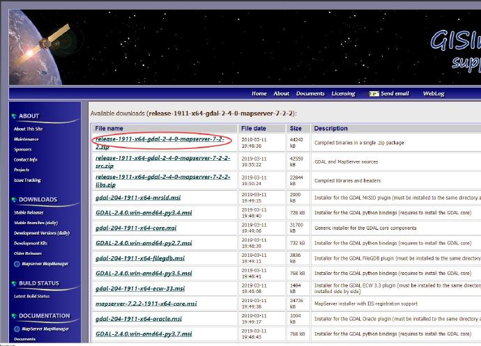
不到黄河不死心,再次上GDAL官网,还是没找上,算了,下载一个它的包吧,也许在那里面,下载下来一搜,还真有!!!哈哈哈,皇天不负有心人呀。贴上下载方式:
1.在GISinternal下载zip压缩包,
地址
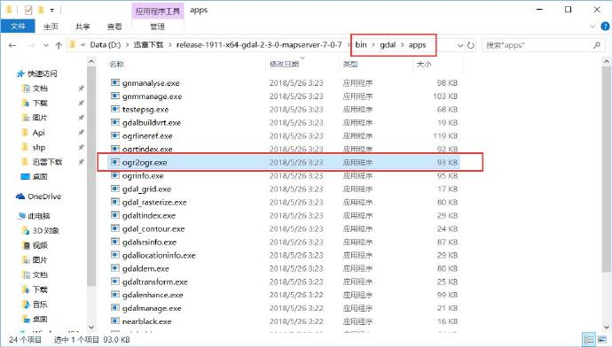
2.解压,找到bin\gdal\apps
现在就可以开始转换了:
以管理员身份打开cmd窗口,进入这个路径:
cd D:\迅雷下载\release\bin\gdal\apps
1、shp转geojson命令:
ogr2ogr -f "GeoJSON" C:\goal.json C:\source.shp
其中goal.json文件会由这个工具自己创建
2、geojson转shp命令:
ogr2ogr -f "ESRI Shapefile" C:\goal.shp C:\source.json
其中goal.shp文件也会由这个工具自己创建
知道了这些个命令,我们在程序里调用它就很容易了,不废话,直接上代码:
C# Code
|
1
2 3 4 5 6 7 8 9 10 11 12 13 14 15 16 17 18 19 20 21 22 23 24 25 26 27 28 29 30 31 32 33 34 35 36 37 38 39 40 41 42 43 44 45 46 47 48 49 50 51 52 53 54 55 56 57 58 59 60 61 62 63 |
/// /// 调用ogr2ogr.exe将shp转为geojson /// /// shp文件路径 public static string RunJsonConvertProcess( string shpfile) { try { string dataDir = Directory.GetCurrentDirectory(); string accessPath = dataDir + @ "\bin\gdal\apps" ; string fileName = Path.GetFileNameWithoutExtension(shpfile); var jsonPath = shpfile.Substring( 0 , shpfile.LastIndexOf( "\" ) + 1 ) + fileName + ".json" ; if (!File.Exists(accessPath + "\\ogr2ogr.exe" )) throw new Exception( "不存在转换工具ogr2ogr" ); string cmd = $ "ogr2ogr -f " GeoJSON\ " {jsonPath} {shpfile}" ; string str = string .Format(@ "C:&cd {0}&{1}&{2}" , accessPath, cmd, "exit" ); RunCmd(str); if (File.Exists(jsonPath)) return jsonPath; else return "" ; } catch (Exception e) { return "error:" +e.Message; } } /// /// 执行cmd命令 /// 多命令请使用批处理命令连接符: /// /// &:同时执行多个命令 /// |:将上一个命令的输出,作为下一个命令的输入 /// &&:当&&前的命令成功时,才执行&&后的命令 /// ||:当||前的命令失败时,才执行||后的命令 /// /// public static void RunCmd( string cmd) { cmd = cmd.Trim().TrimEnd( '&' ) + "&exit" ; //说明:不管命令是否成功均执行exit命令,否则当调用ReadToEnd()方法时,会处于假死状态 using (Process p = new Process()) { Console.InputEncoding = Encoding.UTF8; p.StartInfo.FileName = @ "C:\Windows\System32\cmd.exe" ; p.StartInfo.UseShellExecute = false ; //是否使用操作系统shell启动 p.StartInfo.RedirectStandardInput = true ; //接受来自调用程序的输入信息 p.StartInfo.RedirectStandardOutput = true ; //由调用程序获取输出信息 p.StartInfo.RedirectStandardError = true ; //重定向标准错误输出 p.StartInfo.CreateNoWindow = true ; //不显示程序窗口 p.Start(); //启动程序 //向cmd窗口写入命令 p.StandardInput.WriteLine(cmd); p.StandardInput.AutoFlush = true ; //获取cmd窗口的输出信息 //output = p.StandardOutput.ReadToEnd(); p.WaitForExit(); //等待程序执行完退出进程 p.Close(); } } |
总结:shp2pgsql工具只能向某张特定的表导入数据,灵活性太差。ogr2ogr可以转换任意shp为geojson,非常灵活,我们当然选择后者。周五了,解决了一个大问题,可以愉快地过周末了,本次教程就分享到这里,我们下次再会。
------------------------------------------------------------------------------
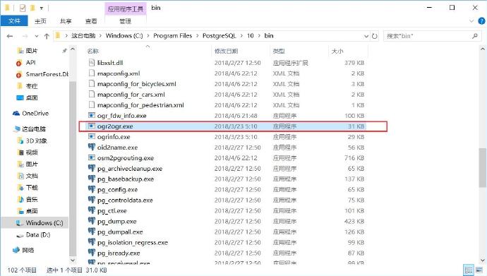
2019.4.24更新:我在postgresql的安装目录中的bin文件夹中也找到ogr2ogr工具,太令人吃惊了!!!
-----------------------------------------------------------------------------------------------------------------
2019.4.26更新:之前代码好好的运行,最近不知道怎么突然不能用了,报错'ogr2ogr ' is not recognized as an internal or external command, operable program or batch file.折腾了好久才发现是环境变量的问题,但是我们已经设置了环境变量了啊,但是程序不认,于是我们只好在程序里设置下环境变量。
废话不多说,我们直接上代码,这次的代码包括三个方法,因为之前的函数名命名并不好,所以我们这次重新命名一下:
1、Shp2GeoJsonByGDAL 使用GDAL将shp转为geojson
2、Shp2GeoJsonByOgr 调用ogr2ogr.exe将shp转为geojson
3、Shp2PostgreSql 调用shp2pgsql工具生成sql文件
4、RunCmd 执行cmd命令
C# Code
|
1
2 3 4 5 6 7 8 9 10 11 12 13 14 15 16 17 18 19 20 21 22 23 24 25 26 27 28 29 30 31 32 33 34 35 36 37 38 39 40 41 42 43 44 45 46 47 48 49 50 51 52 53 54 55 56 57 58 59 60 61 62 63 64 65 66 67 68 69 70 71 72 73 74 75 76 77 78 79 80 81 82 83 84 85 86 87 88 89 90 91 92 93 94 95 96 97 98 99 100 101 102 103 104 105 106 107 108 109 110 111 112 113 114 115 116 117 118 119 120 121 122 123 124 125 126 127 128 129 130 131 132 133 134 135 136 137 138 139 140 141 142 143 144 |
///
/// 使用GDAL将shp转为geojson /// /// shp文件全路径 /// public static List<</span>object> Shp2GeoJsonByGDAL(string shapeFilePath) { try { // 为了支持中文路径 Gdal.SetConfigOption("GDAL_FILENAME_IS_UTF8", "YES"); // 为了使属性表字段支持中文 Gdal.SetConfigOption("SHAPE_ENCODING", ""); Gdal.AllRegister(); Ogr.RegisterAll(); Driver drv = Ogr.GetDriverByName("ESRI Shapefile"); var ds = drv.Open(shapeFilePath, 0); Layer layer = ds.GetLayerByIndex(0); Feature f; layer.ResetReading(); List<</span>object> sb = new List<</span>object>(); while ((f = layer.GetNextFeature()) != null) { var geom = f.GetGeometryRef(); if (geom != null) { var geometryJson = geom.ExportToJson(new string[] { }); var obj = JsonConvert.DeserializeObject(geometryJson); sb.Add(obj); } } return sb; } catch (Exception e) { throw e; } } /// /// 调用ogr2ogr.exe将shp转为geojson /// /// shp文件路径 public static string Shp2GeoJsonByOgr(string shpfile) { try { string dataDir = Directory.GetCurrentDirectory(); string accessPath = dataDir + @"\bin\postgresql"; string fileName = Path.GetFileNameWithoutExtension(shpfile); var jsonPath = shpfile.Substring(0, shpfile.LastIndexOf("\") + 1) + fileName + ".json"; if (!File.Exists(accessPath + "\\ogr2ogr.exe")) throw new Exception("不存在转换工具ogr2ogr"); string cmd = $"ogr2ogr -f "GeoJSON\" {jsonPath} {shpfile}"; string str = string.Format(@"C:&cd {0}&{1}&{2}", accessPath, cmd,"exit"); RunCmd(accessPath,str); if(File.Exists(jsonPath)) return jsonPath; else return ""; } catch (Exception e) { return "error:"+e.Message; } } /// /// 执行cmd命令 /// 多命令请使用批处理命令连接符: /// /// &:同时执行多个命令 /// |:将上一个命令的输出,作为下一个命令的输入 /// &&:当&&前的命令成功时,才执行&&后的命令 /// ||:当||前的命令失败时,才执行||后的命令 /// /// 要设置的环境变量 /// 要执行的cmd命令 public static string RunCmd(string environmentVariable, string cmd) { cmd = cmd.Trim().TrimEnd('&') + "&exit";//说明:不管命令是否成功均执行exit命令,否则当调用ReadToEnd()方法时,会处于假死状态 string res = ""; using (Process p = new Process()) { //先设置环境变量,再运行 string path = Environment.GetEnvironmentVariable("path"); Environment.SetEnvironmentVariable("path", path + environmentVariable + ";"); //.NET Core不支持gbk和gb2312,这里需要处理一下 Encoding.RegisterProvider(CodePagesEncodingProvider.Instance); Console.InputEncoding = Encoding.UTF8; p.StartInfo.FileName = @"C:\Windows\System32\cmd.exe"; p.StartInfo.UseShellExecute = false; //是否使用操作系统shell启动 p.StartInfo.RedirectStandardInput = true; //接受来自调用程序的输入信息 p.StartInfo.RedirectStandardOutput = true; //由调用程序获取输出信息 p.StartInfo.RedirectStandardError = true; //重定向标准错误输出 p.StartInfo.CreateNoWindow = true; //不显示程序窗口 p.Start();//启动程序 //向cmd窗口写入命令 p.StandardInput.WriteLine(cmd); p.StandardInput.AutoFlush = true; p.WaitForExit();//等待程序执行完退出进程 //获取cmd窗口的输出信息 string s = p.StandardOutput.ReadToEnd(); //获取错误信息 string error = p.StandardError.ReadToEnd(); byte[] bytes = Encoding.GetEncoding("GB2312").GetBytes(s); res = Encoding.UTF8.GetString(bytes); p.Close(); } return res; } /// /// 调用shp2pgsql工具生成sql文件 /// /// public static string Shp2PostgreSql(string shpfile) { try { string dataDir = Directory.GetCurrentDirectory(); string accessPath = dataDir + @"\bin\postgresql"; string fileName = Path.GetFileNameWithoutExtension(shpfile); var sqlPath = shpfile.Substring(0, shpfile.LastIndexOf("\") + 1) + fileName + ".sql"; if (!File.Exists(accessPath + "\\shp2pgsql.exe")) throw new Exception("不存在转换工具shp2pgsql"); string cmd = $"shp2pgsql -s 3857 -a -W "gbk\" -k -g "Shape\" {shpfile} "YZL\"."LDBG_QHTB_PY\" >{sqlPath}"; string str = string.Format(@"C:&cd {0}&{1}&{2}", accessPath, cmd, "exit"); RunCmd(accessPath, str); if (File.Exists(sqlPath)) return sqlPath; else return ""; } catch (Exception e) { return "error:" + e.Message; } } |


 491
491

 被折叠的 条评论
为什么被折叠?
被折叠的 条评论
为什么被折叠?
 到【灌水乐园】发言


