


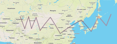
 最终的样子
最终的样子
 +
+
mapboxgl 官网的例子 :https://docs.mapbox.com/mapbox-gl-js/example/animate-a-line/
turf.js 官网:http://turfjs.org/
requestAnimationFrame 详解 我觉得写的很好:https://www.jianshu.com/p/fa5512dfb4f5
一、实现思路
1、绘制线
2、绘制一个点,将线的第一个点赋值给点
3、将geometry中线的每个节点值 赋值给点
<template>
  <div class="hello">
    <div id="map" style="width: 100%; height: 100%"></div>
  </div>
</template>

<script>
export default {
  name: "Map",
  data() {
    return {};
  },
  methods: {
    initmap() {
      mapboxgl.accessToken =
        "pk.eyJ1IjoiMTU5MzU3MyIsImEiOiJjamw3bW85dHkwbXlvM3ZzMm5iZnZ6bWJpIn0.W6_MGVjNaImIybFdMJBMpg";
      let initMap = new mapboxgl.Map({
        container: "map",
        style: "mapbox://styles/mapbox/streets-v11",
        zoom: 3, //缩放层级
        center: [108.420679, 36.772537], //进入后展现的中心点
      });
      return initMap;
    },
  },
  mounted() {
    window.map = this.initmap();
    let coor = [
      [74.91932166254529, 43.34799143293915],
      [78.82968043376917, 35.32100587068976],
      [82.20680846345789, 43.283329636323145],
      [84.60634680034286, 35.46590128939705],
      [88.60557736181482, 42.82877118912947],
      [92.07157718176103, 34.07894110138169],
      [100.86988441701243, 42.95898883351077],
      [109.31270449123406, 31.766651099437112],
      [127.53142149351078, 41.17789211364973],
      [135.8853697774751, 33.33965831774536],
      [142.3730104660895, 43.283329636323145],
      [148.94952294496136, 37.39631064993182],
      [152.94875350643326, 44.753129575870986],
    ];
    let origin = coor[0];
    var route = {
      type: "FeatureCollection",
      features: [
        {
          type: "Feature",
          geometry: {
            type: "LineString",
            coordinates: coor,
          },
        },
      ],
    };
    var point = {
      type: "FeatureCollection",
      features: [
        {
          type: "Feature",
          properties: {},
          geometry: {
            type: "Point",
            coordinates: origin,
          },
        },
      ],
    };

    map.on("load", function () {
      map.addSource("route", {
        type: "geojson",
        data: route,
      });

      map.addSource("point", {
        type: "geojson",
        data: point,
      });

      map.addLayer({
        id: "route",
        source: "route",
        type: "line",
        paint: {
          "line-width": 2,
          "line-color": "#007cbf",
        },
      });

      map.addLayer({
        id: "point",
        source: "point",
        type: "symbol",
        layout: {
          "icon-image": "airport-15",
          "icon-rotate": ["get", "bearing"],
          "icon-rotation-alignment": "map",
          "icon-allow-overlap": true,
          "icon-ignore-placement": true,
        },
      });
      console.log(map, map.getStyle(), "map");
      let that = this;
      var steps = 10000;
      var counter = 0;
      function animate() {
        debugger;
        if (counter == coor.length) {
          cancelAnimationFrame(requestAnimationFrame(animate));
          point.features[0].geometry.coordinates = [];
          point.features[0].geometry.coordinates = origin;
          map.getSource("point").setData(point);
          counter = -1;
        } else {
          point.features[0].geometry.coordinates = coor[counter];
          if (counter < coor.length - 1) {
            point.features[0].properties.bearing = turf.bearing(
              turf.point(coor[counter >= steps ? counter - 1 : counter]),
              turf.point(coor[counter >= steps ? counter : counter + 1])
            );
          } else {
            point.features[0].properties.bearing = turf.bearing(
              turf.point(coor[counter >= steps ? counter - 3 : counter - 2]),
              turf.point(coor[counter >= steps ? counter - 2 : counter - 1])
            );
          }
          if (point.features[0].properties.bearing != 0) {
            console.log(map, map.getSource("point"), "map", point);
            console.log(map.getStyle(), map.getSource("point"), "map", point);
            map.getSource("point").setData(point);
          }
        }
        counter++;
        requestAnimationFrame(animate);
      }
      animate(counter);
    });
  },
};
</script>

<style scoped>
.hello {
  width: 100%;
  height: 100%;
}
</style>
是不是很快,原因是我们数据的节点很少,我们需要将线的细化,这里用到的是 turf.lineChunk 转之后发现他不是标准的geometry 线数据
<template>
  <div class="hello">
    <div id="map" style="width: 100%; height: 100%"></div>
  </div>
</template>

<script>
export default {
  name: "Map",
  data() {
    return {};
  },
  methods: {
    initmap() {
      mapboxgl.accessToken =
        "pk.eyJ1IjoiMTU5MzU3MyIsImEiOiJjamw3bW85dHkwbXlvM3ZzMm5iZnZ6bWJpIn0.W6_MGVjNaImIybFdMJBMpg";
      let initMap = new mapboxgl.Map({
        container: "map",
        style: "mapbox://styles/mapbox/streets-v11",
        zoom: 3, //缩放层级
        center: [108.420679, 36.772537], //进入后展现的中心点
      });
      return initMap;
    },
  },
  mounted() {
    window.map = this.initmap();
    let coor_old = [
      [74.91932166254529, 43.34799143293915],
      [78.82968043376917, 35.32100587068976],
      [82.20680846345789, 43.283329636323145],
      [84.60634680034286, 35.46590128939705],
      [88.60557736181482, 42.82877118912947],
      [92.07157718176103, 34.07894110138169],
      [100.86988441701243, 42.95898883351077],
      [109.31270449123406, 31.766651099437112],
      [127.53142149351078, 41.17789211364973],
      [135.8853697774751, 33.33965831774536],
      [142.3730104660895, 43.283329636323145],
      [148.94952294496136, 37.39631064993182],
      [152.94875350643326, 44.753129575870986],
    ];
    let route = {
      type: "FeatureCollection",
      features: [
        {
          type: "Feature",
          geometry: {
            type: "LineString",
            coordinates: coor_old,
          },
        },
      ],
    };

    let routelineChunk = turf.lineChunk(route.features[0], 50, {
      units: "miles",
    });
    // 将转好后的geometry拼接成正常的数据
    let coor = [];
    routelineChunk.features.forEach((el) => {
      el.geometry.coordinates.forEach((yo) => {
        coor.push(yo);
      });
    });
    route.features[0].geometry.coordinates = coor;
    let origin = coor[0];
    let point = {
      type: "FeatureCollection",
      features: [
        {
          type: "Feature",
          properties: {},
          geometry: {
            type: "Point",
            coordinates: origin,
          },
        },
      ],
    };

    map.on("load", function () {
      map.addSource("route", {
        type: "geojson",
        data: route,
      });

      map.addSource("point", {
        type: "geojson",
        data: point,
      });

      map.addLayer({
        id: "route",
        source: "route",
        type: "line",
        paint: {
          "line-width": 2,
          "line-color": "#007cbf",
        },
      });

      map.addLayer({
        id: "point",
        source: "point",
        type: "symbol",
        layout: {
          "icon-image": "airport-15",
          "icon-rotate": ["get", "bearing"],
          "icon-rotation-alignment": "map",
          "icon-allow-overlap": true,
          "icon-ignore-placement": true,
        },
      });
      let that = this;
      let steps = 10000;
      let counter = 0;
      function animate() {
        debugger;
        if (counter == coor.length) {
          cancelAnimationFrame(requestAnimationFrame(animate));
          point.features[0].geometry.coordinates = [];
          point.features[0].geometry.coordinates = origin;
          map.getSource("point").setData(point);
          counter = -1;
        } else {
          point.features[0].geometry.coordinates = coor[counter];
          if (counter < coor.length - 1) {
            point.features[0].properties.bearing = turf.bearing(
              turf.point(coor[counter >= steps ? counter - 1 : counter]),
              turf.point(coor[counter >= steps ? counter : counter + 1])
            );
          } else {
            point.features[0].properties.bearing = turf.bearing(
              turf.point(coor[counter >= steps ? counter - 3 : counter - 2]),
              turf.point(coor[counter >= steps ? counter - 2 : counter - 1])
            );
          }
          if (point.features[0].properties.bearing != 0) {
            map.getSource("point").setData(point);
          }
        }
        counter++;
        requestAnimationFrame(animate);
      }
      animate(counter);
    });
  },
};
</script>

<style scoped>
.hello {
  width: 100%;
  height: 100%;
}
</style>
线的数据是一样的,移动的数据是空的,我们将每次都push更新数据
最终的代码
<template>
  <div class="hello">
    <div id="map" style="width: 100%; height: 100%"></div>
  </div>
</template>

<script>
export default {
  name: "Map",
  data() {
    return {};
  },
  methods: {
    initmap() {
      mapboxgl.accessToken =
        "pk.eyJ1IjoiMTU5MzU3MyIsImEiOiJjamw3bW85dHkwbXlvM3ZzMm5iZnZ6bWJpIn0.W6_MGVjNaImIybFdMJBMpg";
      let initMap = new mapboxgl.Map({
        container: "map",
        style: "mapbox://styles/mapbox/streets-v11",
        zoom: 3, //缩放层级
        center: [108.420679, 36.772537], //进入后展现的中心点
      });
      return initMap;
    },
  },
  mounted() {
    window.map = this.initmap();
    let coor_old = [
      [74.91932166254529, 43.34799143293915],
      [78.82968043376917, 35.32100587068976],
      [82.20680846345789, 43.283329636323145],
      [84.60634680034286, 35.46590128939705],
      [88.60557736181482, 42.82877118912947],
      [92.07157718176103, 34.07894110138169],
      [100.86988441701243, 42.95898883351077],
      [109.31270449123406, 31.766651099437112],
      [127.53142149351078, 41.17789211364973],
      [135.8853697774751, 33.33965831774536],
      [142.3730104660895, 43.283329636323145],
      [148.94952294496136, 37.39631064993182],
      [152.94875350643326, 44.753129575870986],
    ];
    let route = {
      type: "FeatureCollection",
      features: [
        {
          type: "Feature",
          geometry: {
            type: "LineString",
            coordinates: coor_old,
          },
        },
      ],
    };
    let routeMove = {
      type: "FeatureCollection",
      features: [
        {
          type: "Feature",
          geometry: {
            type: "LineString",
            coordinates: [],
          },
        },
      ],
    };
    let speed = 50; // 运行速度
    let routelineChunk = turf.lineChunk(route.features[0], speed, {
      units: "miles",
    });
    // 将转好后的geometry拼接成正常的数据
    let coor = [];
    routelineChunk.features.forEach((el) => {
      el.geometry.coordinates.forEach((yo) => {
        coor.push(yo);
      });
    });
    route.features[0].geometry.coordinates = coor;
    let origin = coor[0];
    let point = {
      type: "FeatureCollection",
      features: [
        {
          type: "Feature",
          properties: {},
          geometry: {
            type: "Point",
            coordinates: origin,
          },
        },
      ],
    };

    map.on("load", function () {
      map.addSource("route", {
        type: "geojson",
        data: route,
      });
      map.addSource("routeMove", {
        type: "geojson",
        data: routeMove,
      });
      map.addSource("point", {
        type: "geojson",
        data: point,
      });
      map.addLayer({
        id: "route",
        source: "route",
        type: "line",
        paint: {
          "line-width": 10,
          "line-color": "#F22C2C",
          "line-opacity": 0.3,
        },
        layout: {
          "line-cap": "round",
          "line-join": "round",
        },
      });
      map.addLayer({
        id: "routeMove",
        source: "routeMove",
        type: "line",
        paint: {
          "line-width": 2,
          "line-color": "#007cbf",
          "line-opacity": 1,
        },
        layout: {
          "line-cap": "round",
          "line-join": "round",
        },
      });
      map.addLayer({
        id: "point",
        source: "point",
        type: "symbol",
        layout: {
          "icon-image": "airport-15",
          "icon-rotate": ["get", "bearing"],
          "icon-rotation-alignment": "map",
          "icon-allow-overlap": true,
          "icon-ignore-placement": true,
        },
      });
      let that = this;
      let steps = 10000;
      let counter = 0;
      function animate() {
        if (counter == coor.length) {
          cancelAnimationFrame(requestAnimationFrame(animate));
          point.features[0].geometry.coordinates = [];
          point.features[0].geometry.coordinates = origin;
          map.getSource("point").setData(point);
          counter = -1;
          routeMove.features[0].geometry.coordinates = [];
        } else {
          // 移动添加点数据
          point.features[0].geometry.coordinates = coor[counter];
          if (counter < coor.length - 1) {
            point.features[0].properties.bearing = turf.bearing(
              turf.point(coor[counter >= steps ? counter - 1 : counter]),
              turf.point(coor[counter >= steps ? counter : counter + 1])
            );
          } else {
            point.features[0].properties.bearing = turf.bearing(
              turf.point(coor[counter >= steps ? counter - 3 : counter - 2]),
              turf.point(coor[counter >= steps ? counter - 2 : counter - 1])
            );
          }
          if (point.features[0].properties.bearing != 0) {
            map.getSource("point").setData(point);
          }
          // 添加线数据
          routeMove.features[0].geometry.coordinates.push(coor[counter]);
          map.getSource("routeMove").setData(routeMove);
        }
        counter++;
        requestAnimationFrame(animate);
      }
      animate(counter);
    });
  },
};
</script>

<style scoped>
.hello {
  width: 100%;
  height: 100%;
}
</style>
这个最后可以拓展就可以实现, keep 上面的轨迹了


 1万+
1万+


 被折叠的 条评论
为什么被折叠?
被折叠的 条评论
为什么被折叠?
 到【灌水乐园】发言


