


无论是在
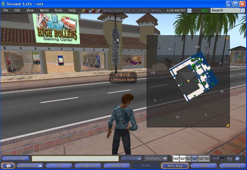
2D的游戏里,还是在3D的游戏里,雷达地图的实现,都是比较基本的功能了。因为随着游戏世界里越来越大,参加的玩家也越来越多,需要一个大体的地图来让玩家方便地看到全局的概貌。比如在打对战的游戏里,更加需要了解别人在那里战斗了。有了雷达地图之后,就可以让玩家更加方便地了解全局地图上发生的事情,也方便玩家相互查找,也让玩家不会走迷路。下面就来了解第二生里的怎么样实现雷达地图的实现,它的显示界面如下:
它主要通过类
LLNetMap来实现的,它的声明代码如下:
#001 class LLNetMap : public LLUICtrl
#002 {
#003 public:
构造函数和析构函数。
#004
LLNetMap(const std::string& name, const LLRect& rect, const LLColor4& bg_color );
#005
virtual ~LLNetMap();
#006
返回窗口的类型。
#007
virtual EWidgetType getWidgetType() const;
#008
virtual LLString getWidgetTag() const;
#009
显示雷达地图。
#010
virtual void draw();
响应事件消息处理。
#011
virtual BOOL handleDoubleClick( S32 x, S32 y, MASK mask );
#012
virtual BOOL handleRightMouseDown( S32 x, S32 y, MASK mask );
#013
virtual BOOL handleScrollWheel(S32 x, S32 y, S32 clicks);
#014
virtual BOOL handleToolTip( S32 x, S32 y, LLString& msg, LLRect* sticky_rect_screen );
#015
设置缩放大小倍数。
#016
void setScale( F32 scale );
平移位置。
#017
void translatePan( F32 delta_x, F32 delta_y );
#018
void setPan( F32 x, F32 y ) { mTargetPanX = x; mTargetPanY = y; }
#019
#020
const LLVector3d& getObjectImageCenterGlobal() { return mObjectImageCenterGlobal; }
显示相应的点。
#021
void renderPoint(const LLVector3 &pos, const LLColor4U &color,
#022
S32 diameter, S32 relative_height = 0);
#023
void renderScaledPointGlobal( const LLVector3d& pos, const LLColor4U &color, F32 radius );
#024
#025
LLVector3 globalPosToView(const LLVector3d& global_pos);
#026
LLVector3d viewPosToGlobal(S32 x,S32 y);
#027
#028
static void setRotateMap( BOOL b ) { LLNetMap::sRotateMap = b; }
#029
static void handleZoomLevel(void* which);
#030
显示右下角的拉动箭头。
#031
void drawTracking( const LLVector3d& pos_global,
#032
const LLColor4& color,
#033
BOOL draw_arrow = TRUE);
#034
#035 protected:
#036
void setDirectionPos( LLTextBox* text_box, F32 rotation );
#037
void createObjectImage();
#038
static void teleport( const LLVector3d& destination );
#039
static void fly( const LLVector3d& destination );
#040
#041 public:
保存相应的属性。
#042
LLHandle<LLView> mPopupMenuHandle;
#043
LLColor4 mBackgroundColor;
#044
#045
F32 mScale; // Size of a
#046 region in pixels
#047
F32 mPixelsPerMeter; // world meters to map pixels
#048
F32 mObjectMapTPM; // texels per meter on map
#049
F32 mObjectMapPixels; // Width of object map in pixels;
#050
F32 mTargetPanX;
#051
F32 mTargetPanY;
#052
F32 mCurPanX;
#053
F32 mCurPanY;
#054
BOOL mUpdateNow;
#055
LLVector3d mObjectImageCenterGlobal;
#056
LLPointer<LLImageRaw> mObjectRawImagep;
#057
LLPointer<LLImageGL> mObjectImagep;
显示八个方向的文字框。
#058
LLTextBox* mTextBoxEast;
#059
LLTextBox* mTextBoxNorth;
#060
LLTextBox* mTextBoxWest;
#061
LLTextBox* mTextBoxSouth;
#062
#063
LLTextBox* mTextBoxSouthEast;
#064
LLTextBox* mTextBoxNorthEast;
#065
LLTextBox* mTextBoxNorthWest;
#066
LLTextBox* mTextBoxSouthWest;
#067
#068
LLRotateNetMapListener mNetMapListener;
#069
#070
static BOOL sRotateMap;
#071
static LLNetMap* sInstance;
#072 };
通过上面的类,就可以看到雷达地图实现的基本属性、大体框架,下一次再来详细地分析它是怎么实现显示点来代表全局的物体。


 1080
1080

 被折叠的 条评论
为什么被折叠?
被折叠的 条评论
为什么被折叠?
 到【灌水乐园】发言


