


看了Servlet-based Google Earth Tours感觉挺好,不过他这个不够简单,我来仿照KML官方网站的python例子,写个简单的小例子把文章的精髓拿出来.
快速体验:
1. 把下面的getest.kml和getest.py保存到本机。
2.把getest.py的第一行改成你的python解释器路径,并放到Apache的cgi-bin下。
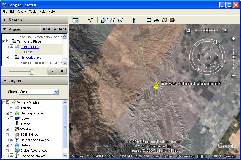
3. 双击getest.kml会启动google earth,在Place面板里会出现Python Demo目录,选中它,当你移动屏幕的时候,你会发现屏幕中心一直会有一个placemark,这个placemark是python程序动态返回的。
原理介绍:
1. 先看看KML的<NetworkLink>标签的样子,比如getest.kml
 <?
xml version="1.0" encoding="UTF-8"
?>
<
kml
xmlns
="http://earth.google.com/kml/2.2"
>
<
Folder
>
<
name
>
Python Demo
</
name
>
<
visibility
>
0
</
visibility
>
<
open
>
0
</
open
>
<
description
>
Liu Test
</
description
>
<
NetworkLink
>
<
name
>
Random Placemark
</
name
>
<
visibility
>
0
</
visibility
>
<
open
>
0
</
open
>
<
description
>
my discription
</
description
>
<
refreshVisibility
>
0
</
refreshVisibility
>
<
flyToView
>
0
</
flyToView
>
<
Link
>
<
href
>
http://localhost/cgi-bin/getest.py
</
href
>
<
refreshInterval
>
2
</
refreshInterval
>
<
viewRefreshMode
>
onStop
</
viewRefreshMode
>
<
viewRefreshTime
>
1
</
viewRefreshTime
>
</
Link
>
</
NetworkLink
>
</
Folder
>
</
kml
>
<?
xml version="1.0" encoding="UTF-8"
?>
<
kml
xmlns
="http://earth.google.com/kml/2.2"
>
<
Folder
>
<
name
>
Python Demo
</
name
>
<
visibility
>
0
</
visibility
>
<
open
>
0
</
open
>
<
description
>
Liu Test
</
description
>
<
NetworkLink
>
<
name
>
Random Placemark
</
name
>
<
visibility
>
0
</
visibility
>
<
open
>
0
</
open
>
<
description
>
my discription
</
description
>
<
refreshVisibility
>
0
</
refreshVisibility
>
<
flyToView
>
0
</
flyToView
>
<
Link
>
<
href
>
http://localhost/cgi-bin/getest.py
</
href
>
<
refreshInterval
>
2
</
refreshInterval
>
<
viewRefreshMode
>
onStop
</
viewRefreshMode
>
<
viewRefreshTime
>
1
</
viewRefreshTime
>
</
Link
>
</
NetworkLink
>
</
Folder
>
</
kml
>
这里主要有两个地方:
一个是 <href>http://localhost/cgi-bin/getest.py</href> ,GE向这个URL要数据,并把BBOX以GET方式发送到该URL,比如http://localhost/cgi-bin/getest.py?bbox=121,36,122,37
另一个是<refreshInterval>2</refreshInterval> <viewRefreshMode>onStop</viewRefreshMode> <viewRefreshTime>1</viewRefreshTime>
这几个标签指定了GE发送数据的时间间隔和其他设定。
当我们在GE中打开这个KML文件的时候,GE就回向 http://localhost/cgi-bin/getest.py 要数据,我们就可以在getest.py中对该请求进行处理,并返回结果(KML)。
2. 第二步就是编写getest.py处理这个响应,最简单的是返回一个位于屏幕中心的地标,代码如下:
#
!C:/Python24/python.exe
#
replace the line above with our own python path
import
cgiurl
=
cgi.FieldStorage()bbox
=
url[
'
BBOX
'
].valuebbox
=
bbox.split(
'
,
'
)west
=
float(bbox[0])south
=
float(bbox[
1
])east
=
float(bbox[
2
])north
=
float(bbox[
3
])center_lng
=
((east
-
west)
/
2
)
+
westcenter_lat
=
((north
-
south)
/
2
)
+
southkml
=
(
'
<?xml version="1.0" encoding="UTF-8"?>
'
'
<kml xmlns="http://earth.google.com/kml/2.2">
'
'
<Placemark>
'
'
<name>View-centered placemark</name>
'
'
<Point>
'
'
<coordinates>%.6f,%.6f</coordinates>
'
'
</Point>
'
'
</Placemark>
'
'
</kml>
'
)
%
(center_lng, center_lat)
print
'
Content-Type: application/vnd.google-earth.kml+xml
'
print
kml
我们也可以在getest.py中编写复杂的功能,比如从数据库中提取数据生成KML文件,然后返回客户端与GE的数据叠加。原理介绍,简单至上,就这么简单吧。
学习资料(摘自http://www.javaworld.com/javaworld/jw-11-2005/jw-1114-google.html):
Resources
- Download the source code that accompanies this article “Servlet-based Google Earth Tours”
http://www.javaworld.com/javaworld/jw-11-2005/google/jw-1114-google.zip - Cylindrical projection
http://mathworld.wolfram.com/CylindricalProjection.html - Google Earth API
http://code.google.com/apis.html#earth - Google Earth Community
http://bbs.keyhole.com/ubb/ubbthreads.php/Cat/0 - Google Earth download
http://earth.google.com/download-earth.html - Google Earth homepage
http://earth.google.com/ - Hibernate framework
http://www.hibernate.org/ - iBATIS framework
http://ibatis.apache.org/index.html - Jamon framework
http://www.jamon.org/Features.html - Microsoft Virtual Earth
http://virtualearth.msn.com/ - Nasa World Wind
http://worldwind.arc.nasa.gov/ - Google Earth KML Tutorial, where you'll find the algorithm for centering
http://www.keyhole.com/kml/kml_tut.html#tracking_point - For more articles on servlets, browse the Servlets section of JavaWorld's Topical Index
http://www.javaworld.com/channel_content/jw-servlets-index.shtml - For more articles on how to put your Java skills to work, browse the Applied Java section of JavaWorld's Topical Index
http://www.javaworld.com/channel_content/jw-applied-index.shtml


 7995
7995


 被折叠的 条评论
为什么被折叠?
被折叠的 条评论
为什么被折叠?
 到【灌水乐园】发言


