


更新:2019年8月
为了促进同行业人员(特指 LiDAR 点云处理人员或相近行业)的技术交流,解决平时开发过程中遇到的技术性问题,博主建立一个QQ群,欢迎大家积极加入,共同引领点云行业的快速发展 ~
群名:LiDAR点云部落
群号:190162198

说明
- 以下均为 Being_young 前辈所写,现转载过来,再加上自己的理解,重新写了一遍,方便自己日后使用
- 博客地址:http://blog.csdn.net/u013019296/article/
PCL 深度图像
在 PCL 中深度图像与点云最主要的区别在于其近邻的检索方式的不同,并且可以互相转换
深度图像,也称为距离影像(Range Image),是指将从图像采集器到场景中各点的距离值作为像素值的图像,它直接反应了景物可见表面的几何形状,利用它可以很方便的解决3D目标描述中的许多问题,深度图像经过点云变换可以计算为点云数据,有规则及有必要信息的点云数据可以反算为深度图像数据。
点云,当一束激光照射到物体表面时,所反射的激光会携带方位、距离等信息。若将激光束按照某种轨迹进行扫描,便会边扫描边记录到反射的激光点信息,由 于扫描极为精细,则能够得到大量的激光点,因而就可形成激光点云。点云格式有.las ;*.pcd; .txt等
rangeimage是来自传感器一个特定角度拍摄的一个三维场景获取的有规则的有焦距等基本信息的深度图
深度图像的像素值代表从传感器到物体的距离或者深度值
目前深度图像的获取方法有:
- 计算机立体视觉成像
- 激光雷达深度成像法
- 莫尔条纹法
- 结构光法等
针对深度图像的研究重点主要集中在以下几个方面:
- 深度图像的分割技术
- 深度图像的边缘检测技术
- 基于不同视点的多幅深度图像的配准技术
- 基于深度数据的三维重建技术
- 基于三维深度图像的三维目标识别技术
- 深度图像的多分辨率建模和几何压缩技术等
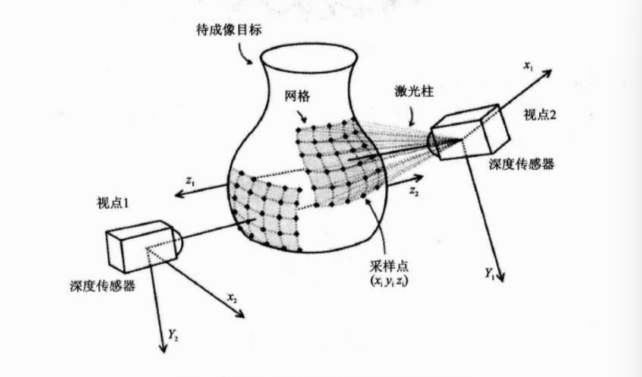
不同视角获得深度图像的过程:
代码片段一:获得深度图像
//如何获得深度图像
#include <pcl/range_image/range_image.h>    //深度图像的头文件

int main (int argc, char** argv) {
  pcl::PointCloud<pcl::PointXYZ> pointCloud;   //定义点云的对象

  // 循环产生点云的数据
  for (float y=-0.5f; y<=0.5f; y+=0.01f) {
    for (float z=-0.5f; z<=0.5f; z+=0.01f) {
      pcl::PointXYZ point;
      point.x = 2.0f - y;
      point.y = y;
      point.z = z;
      pointCloud.points.push_back(point); //循环添加点数据到点云对象
    }
  }
  pointCloud.width = (uint32_t) pointCloud.points.size();
  pointCloud.height = 1;                                        //设置点云对象的头信息
    //实现一个呈矩形形状的点云
  // We now want to create a range image from the above point cloud, with a 1deg angular resolution
   //angular_resolution为模拟的深度传感器的角度分辨率,即深度图像中一个像素对应的角度大小
  float angularResolution = (float) (  1.0f * (M_PI/180.0f));  //   1.0 degree in radians
   //max_angle_width为模拟的深度传感器的水平最大采样角度,
  float maxAngleWidth     = (float) (360.0f * (M_PI/180.0f));  // 360.0 degree in radians
  //max_angle_height为模拟传感器的垂直方向最大采样角度  都转为弧度
  float maxAngleHeight    = (float) (180.0f * (M_PI/180.0f));  // 180.0 degree in radians
   //传感器的采集位置
  Eigen::Affine3f sensorPose = (Eigen::Affine3f)Eigen::Translation3f(0.0f, 0.0f, 0.0f);
   //深度图像遵循坐标系统
  pcl::RangeImage::CoordinateFrame coordinate_frame = pcl::RangeImage::CAMERA_FRAME;
  float noiseLevel=0.00;    //noise_level获取深度图像深度时,近邻点对查询点距离值的影响水平
  float minRange = 0.0f;     //min_range设置最小的获取距离,小于最小获取距离的位置为传感器的盲区
  int borderSize = 1;        //border_size获得深度图像的边缘的宽度

  pcl::RangeImage rangeImage;
  rangeImage.createFromPointCloud(pointCloud, angularResolution, maxAngleWidth, maxAngleHeight,
                                  sensorPose, coordinate_frame, noiseLevel, minRange, borderSize);

  std::cout << rangeImage << "\n";
}
代码片段二:有序点云数据深度图像
#include <iostream>
#include <boost/thread/thread.hpp>
#include <pcl/common/common_headers.h>
#include <pcl/range_image/range_image.h>    //关于深度图像的头文件
#include <pcl/io/pcd_io.h>
#include <pcl/visualization/range_image_visualizer.h>   //深度图可视化的头文件
#include <pcl/visualization/pcl_visualizer.h>      //PCL可视化的头文件
#include <pcl/console/parse.h>

typedef pcl::PointXYZ PointType;
//参数
float angular_resolution_x = 0.5f,//angular_resolution为模拟的深度传感器的角度分辨率,即深度图像中一个像素对应的角度大小
      angular_resolution_y = angular_resolution_x;
pcl::RangeImage::CoordinateFrame coordinate_frame = pcl::RangeImage::CAMERA_FRAME;//深度图像遵循坐标系统
bool live_update = false;
//命令帮助提示
void
printUsage (const char* progName)
{
  std::cout << "\n\nUsage: "<<progName<<" [options] <scene.pcd>\n\n"
            << "Options:\n"
            << "-------------------------------------------\n"
            << "-rx <float>  angular resolution in degrees (default "<<angular_resolution_x<<")\n"
            << "-ry <float>  angular resolution in degrees (default "<<angular_resolution_y<<")\n"
            << "-c <int>     coordinate frame (default "<< (int)coordinate_frame<<")\n"
            << "-l           live update - update the range image according to the selected view in the 3D viewer.\n"
            << "-h           this help\n"
            << "\n\n";
}

void
setViewerPose (pcl::visualization::PCLVisualizer& viewer, const Eigen::Affine3f& viewer_pose)
{
  Eigen::Vector3f pos_vector = viewer_pose * Eigen::Vector3f(0, 0, 0);
  Eigen::Vector3f look_at_vector = viewer_pose.rotation () * Eigen::Vector3f(0, 0, 1) + pos_vector;
  Eigen::Vector3f up_vector = viewer_pose.rotation () * Eigen::Vector3f(0, -1, 0);
  viewer.setCameraPosition (pos_vector[0], pos_vector[1], pos_vector[2],
                            look_at_vector[0], look_at_vector[1], look_at_vector[2],
                            up_vector[0], up_vector[1], up_vector[2]);
}

//主函数
int
main (int argc, char** argv)
{
  //输入命令分析
  if (pcl::console::find_argument (argc, argv, "-h") >= 0)
  {
    printUsage (argv[0]);
    return 0;
  }
  if (pcl::console::find_argument (argc, argv, "-l") >= 0)
  {
    live_update = true;
    std::cout << "Live update is on.\n";
  }
  if (pcl::console::parse (argc, argv, "-rx", angular_resolution_x) >= 0)
    std::cout << "Setting angular resolution in x-direction to "<<angular_resolution_x<<"deg.\n";
  if (pcl::console::parse (argc, argv, "-ry", angular_resolution_y) >= 0)
    std::cout << "Setting angular resolution in y-direction to "<<angular_resolution_y<<"deg.\n";
  int tmp_coordinate_frame;
  if (pcl::console::parse (argc, argv, "-c", tmp_coordinate_frame) >= 0)
  {
    coordinate_frame = pcl::RangeImage::CoordinateFrame (tmp_coordinate_frame);
    std::cout << "Using coordinate frame "<< (int)coordinate_frame<<".\n";
  }
  angular_resolution_x = pcl::deg2rad (angular_resolution_x);
  angular_resolution_y = pcl::deg2rad (angular_resolution_y);

  //读取点云PCD文件  如果没有输入PCD文件就生成一个点云
  pcl::PointCloud<PointType>::Ptr point_cloud_ptr (new pcl::PointCloud<PointType>);
  pcl::PointCloud<PointType>& point_cloud = *point_cloud_ptr;
  Eigen::Affine3f scene_sensor_pose (Eigen::Affine3f::Identity ());   //申明传感器的位置是一个4*4的仿射变换
  std::vector<int> pcd_filename_indices = pcl::console::parse_file_extension_argument (argc, argv, "pcd");
  if (!pcd_filename_indices.empty ())
  {
    std::string filename = argv[pcd_filename_indices[0]];
    if (pcl::io::loadPCDFile (filename, point_cloud) == -1)
    {
      std::cout << "Was not able to open file \""<<filename<<"\".\n";
      printUsage (argv[0]);
      return 0;
    }
   //给传感器的位姿赋值  就是获取点云的传感器的的平移与旋转的向量
    scene_sensor_pose = Eigen::Affine3f (Eigen::Translation3f (point_cloud.sensor_origin_[0],
                                                             point_cloud.sensor_origin_[1],
                                                             point_cloud.sensor_origin_[2])) *
                        Eigen::Affine3f (point_cloud.sensor_orientation_);
  }
  else
  {  //如果没有给点云,则我们要自己生成点云
    std::cout << "\nNo *.pcd file given => Genarating example point cloud.\n\n";
    for (float x=-0.5f; x<=0.5f; x+=0.01f)
    {
      for (float y=-0.5f; y<=0.5f; y+=0.01f)
      {
        PointType point;  point.x = x;  point.y = y;  point.z = 2.0f - y;
        point_cloud.points.push_back (point);
      }
    }
    point_cloud.width = (int) point_cloud.points.size ();  point_cloud.height = 1;
  }

  // -----从创建的点云中获取深度图--//
  //设置基本参数
  float noise_level = 0.0;
  float min_range = 0.0f;
  int border_size = 1;
  boost::shared_ptr<pcl::RangeImage> range_image_ptr(new pcl::RangeImage);
  pcl::RangeImage& range_image = *range_image_ptr;
/*
 关于range_image.createFromPointCloud()参数的解释 (涉及的角度都为弧度为单位) :
   point_cloud为创建深度图像所需要的点云
  angular_resolution_x深度传感器X方向的角度分辨率
  angular_resolution_y深度传感器Y方向的角度分辨率
   pcl::deg2rad (360.0f)深度传感器的水平最大采样角度
   pcl::deg2rad (180.0f)垂直最大采样角度
   scene_sensor_pose设置的模拟传感器的位姿是一个仿射变换矩阵,默认为4*4的单位矩阵变换
   coordinate_frame定义按照那种坐标系统的习惯  默认为CAMERA_FRAME
   noise_level  获取深度图像深度时,邻近点对查询点距离值的影响水平
   min_range 设置最小的获取距离,小于最小的获取距离的位置为传感器的盲区
   border_size  设置获取深度图像边缘的宽度 默认为0
*/
  range_image.createFromPointCloud (point_cloud, angular_resolution_x, angular_resolution_y,pcl::deg2rad (360.0f), pcl::deg2rad (180.0f),scene_sensor_pose, coordinate_frame, noise_level, min_range, border_size);

  //可视化点云
  pcl::visualization::PCLVisualizer viewer ("3D Viewer");
  viewer.setBackgroundColor (1, 1, 1);
  pcl::visualization::PointCloudColorHandlerCustom<pcl::PointWithRange> range_image_color_handler (range_image_ptr, 0, 0, 0);
  viewer.addPointCloud (range_image_ptr, range_image_color_handler, "range image");
  viewer.setPointCloudRenderingProperties (pcl::visualization::PCL_VISUALIZER_POINT_SIZE, 1, "range image");
  //viewer.addCoordinateSystem (1.0f, "global");
  //PointCloudColorHandlerCustom<PointType> point_cloud_color_handler (point_cloud_ptr, 150, 150, 150);
  //viewer.addPointCloud (point_cloud_ptr, point_cloud_color_handler, "original point cloud");
  viewer.initCameraParameters ();
  //range_image.getTransformationToWorldSystem ()的作用是获取从深度图像坐标系统(应该就是传感器的坐标)转换为世界坐标系统的转换矩阵
  setViewerPose(viewer, range_image.getTransformationToWorldSystem ());  //设置视点的位置

  //可视化深度图
  pcl::visualization::RangeImageVisualizer range_image_widget ("Range image");
  range_image_widget.showRangeImage (range_image);

  while (!viewer.wasStopped ())
  {
    range_image_widget.spinOnce ();
    viewer.spinOnce ();
    pcl_sleep (0.01);

    if (live_update)
    {
      //如果选择的是——l的参数说明就是要根据自己选择的视点来创建深度图。
     // live update - update the range image according to the selected view in the 3D viewer.
      scene_sensor_pose = viewer.getViewerPose();
      range_image.createFromPointCloud (point_cloud, angular_resolution_x, angular_resolution_y,
                                        pcl::deg2rad (360.0f), pcl::deg2rad (180.0f),
                                        scene_sensor_pose, pcl::RangeImage::LASER_FRAME, noise_level, min_range, border_size);
      range_image_widget.showRangeImage (range_image);
    }
  }
}
PCL 深度图像提取边界
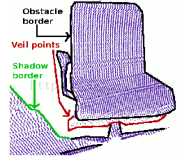
深度图像边界:计从前景跨越到背景的位置定义为边界。具体有:
------ 物体边界:这是物体的最外层和阴影边界的可见点集
------ 阴影边界:毗邻与遮挡的背景上的点集
------ Veil点集:在被遮挡物边界和阴影边界之间的内插点,它们是有激光雷达获取的3D距离数据中的典型数据类型
这三类数据及深度图像的边界如图:
创建深度图像并使其可视化,提取边界信息很重要的一点就是区分深度图像中当前视点不可见点几何和应该可见但处于传感器获取距离范围之外的点集 ,后者可以标记为典型边界,然而当前视点不可见点则不能成为边界。因此,如果后者的测量值存在,则提供那些超出传感器距离获取范围之外的数据对于边界的提取是非常重要的。
#include <iostream>

#include <boost/thread/thread.hpp>
#include <pcl/range_image/range_image.h>
#include <pcl/io/pcd_io.h>
#include <pcl/visualization/range_image_visualizer.h>
#include <pcl/visualization/pcl_visualizer.h>
#include <pcl/features/range_image_border_extractor.h>
#include <pcl/console/parse.h>

typedef pcl::PointXYZ PointType;

// --------------------
// -----Parameters-----
// --------------------
float angular_resolution = 0.5f;
pcl::RangeImage::CoordinateFrame coordinate_frame = pcl::RangeImage::CAMERA_FRAME;
bool setUnseenToMaxRange = false;

// --------------
// -----Help-----
// --------------
void
printUsage (const char* progName)
{
  std::cout << "\n\nUsage: "<<progName<<" [options] <scene.pcd>\n\n"
            << "Options:\n"
            << "-------------------------------------------\n"
            << "-r <float>   angular resolution in degrees (default "<<angular_resolution<<")\n"
            << "-c <int>     coordinate frame (default "<< (int)coordinate_frame<<")\n"
            << "-m           Treat all unseen points to max range\n"
            << "-h           this help\n"
            << "\n\n";
}

// --------------
// -----Main-----
// --------------
int
main (int argc, char** argv)
{
  // --------------------------------------
  // -----Parse Command Line Arguments-----
  // --------------------------------------
  if (pcl::console::find_argument (argc, argv, "-h") >= 0)
  {
    printUsage (argv[0]);
    return 0;
  }
  if (pcl::console::find_argument (argc, argv, "-m") >= 0)
  {
    setUnseenToMaxRange = true;
    cout << "Setting unseen values in range image to maximum range readings.\n";
  }
  int tmp_coordinate_frame;
  if (pcl::console::parse (argc, argv, "-c", tmp_coordinate_frame) >= 0)
  {
    coordinate_frame = pcl::RangeImage::CoordinateFrame (tmp_coordinate_frame);
    cout << "Using coordinate frame "<< (int)coordinate_frame<<".\n";
  }
  if (pcl::console::parse (argc, argv, "-r", angular_resolution) >= 0)
    cout << "Setting angular resolution to "<<angular_resolution<<"deg.\n";
  angular_resolution = pcl::deg2rad (angular_resolution);

  // ------------------------------------------------------------------
  // -----Read pcd file or create example point cloud if not given-----
  // ------------------------------------------------------------------
  pcl::PointCloud<PointType>::Ptr point_cloud_ptr (new pcl::PointCloud<PointType>);
  pcl::PointCloud<PointType>& point_cloud = *point_cloud_ptr;
  pcl::PointCloud<pcl::PointWithViewpoint> far_ranges;
  Eigen::Affine3f scene_sensor_pose (Eigen::Affine3f::Identity ());  //传感器的位置
  std::vector<int> pcd_filename_indices = pcl::console::parse_file_extension_argument (argc, argv, "pcd");
  if (!pcd_filename_indices.empty ())
  {
    std::string filename = argv[pcd_filename_indices[0]];
    if (pcl::io::loadPCDFile (filename, point_cloud) == -1)   //打开文件
    {
      cout << "Was not able to open file \""<<filename<<"\".\n";
      printUsage (argv[0]);
      return 0;
    }
    scene_sensor_pose = Eigen::Affine3f (Eigen::Translation3f (point_cloud.sensor_origin_[0],
                                                               point_cloud.sensor_origin_[1],
                                                               point_cloud.sensor_origin_[2])) *
                        Eigen::Affine3f (point_cloud.sensor_orientation_);  //仿射变换矩阵

    std::string far_ranges_filename = pcl::getFilenameWithoutExtension (filename)+"_far_ranges.pcd";
    if (pcl::io::loadPCDFile(far_ranges_filename.c_str(), far_ranges) == -1)
      std::cout << "Far ranges file \""<<far_ranges_filename<<"\" does not exists.\n";
  }
  else
  {
    cout << "\nNo *.pcd file given => Genarating example point cloud.\n\n";
    for (float x=-0.5f; x<=0.5f; x+=0.01f)      //填充一个矩形的点云
    {
      for (float y=-0.5f; y<=0.5f; y+=0.01f)
      {
        PointType point;  point.x = x;  point.y = y;  point.z = 2.0f - y;
        point_cloud.points.push_back (point);
      }
    }
    point_cloud.width = (int) point_cloud.points.size ();  point_cloud.height = 1;
  }

  // -----------------------------------------------
  // -----Create RangeImage from the PointCloud-----
  // -----------------------------------------------
  float noise_level = 0.0;      //各种参数的设置
  float min_range = 0.0f;
  int border_size = 1;
  boost::shared_ptr<pcl::RangeImage> range_image_ptr (new pcl::RangeImage);
  pcl::RangeImage& range_image = *range_image_ptr;
  range_image.createFromPointCloud (point_cloud, angular_resolution, pcl::deg2rad (360.0f), pcl::deg2rad (180.0f),
                                   scene_sensor_pose, coordinate_frame, noise_level, min_range, border_size);
  range_image.integrateFarRanges (far_ranges);
  if (setUnseenToMaxRange)
    range_image.setUnseenToMaxRange ();

  // --------------------------------------------
  // -----Open 3D viewer and add point cloud-----
  // --------------------------------------------
  pcl::visualization::PCLVisualizer viewer ("3D Viewer");   //创建视口
  viewer.setBackgroundColor (1, 1, 1);                      //设置背景颜色
  viewer.addCoordinateSystem (1.0f);              //设置坐标系
  pcl::visualization::PointCloudColorHandlerCustom<PointType> point_cloud_color_handler (point_cloud_ptr, 0, 0, 0);
  viewer.addPointCloud (point_cloud_ptr, point_cloud_color_handler, "original point cloud");   //添加点云
  //PointCloudColorHandlerCustom<pcl::PointWithRange> range_image_color_handler (range_image_ptr, 150, 150, 150);
  //viewer.addPointCloud (range_image_ptr, range_image_color_handler, "range image");
  //viewer.setPointCloudRenderingProperties (PCL_VISUALIZER_POINT_SIZE, 2, "range image");

  // -------------------------
  // -----Extract borders提取边界的部分-----
  // -------------------------
  pcl::RangeImageBorderExtractor border_extractor (&range_image);
  pcl::PointCloud<pcl::BorderDescription> border_descriptions;
  border_extractor.compute (border_descriptions);     //提取边界计算描述子

  // -------------------------------------------------------
  // -----Show points in 3D viewer在3D 视口中显示点云-----
  // ----------------------------------------------------
  pcl::PointCloud<pcl::PointWithRange>::Ptr border_points_ptr(new pcl::PointCloud<pcl::PointWithRange>),  //物体边界
                                            veil_points_ptr(new pcl::PointCloud<pcl::PointWithRange>),     //veil边界
                                            shadow_points_ptr(new pcl::PointCloud<pcl::PointWithRange>);   //阴影边界
  pcl::PointCloud<pcl::PointWithRange>& border_points = *border_points_ptr,
                                      & veil_points = * veil_points_ptr,
                                      & shadow_points = *shadow_points_ptr;

  for (int y=0; y< (int)range_image.height; ++y)
  {
    for (int x=0; x< (int)range_image.width; ++x)
    {
      if (border_descriptions.points[y*range_image.width + x].traits[pcl::BORDER_TRAIT__OBSTACLE_BORDER])
        border_points.points.push_back (range_image.points[y*range_image.width + x]);

      if (border_descriptions.points[y*range_image.width + x].traits[pcl::BORDER_TRAIT__VEIL_POINT])
        veil_points.points.push_back (range_image.points[y*range_image.width + x]);

      if (border_descriptions.points[y*range_image.width + x].traits[pcl::BORDER_TRAIT__SHADOW_BORDER])
        shadow_points.points.push_back (range_image.points[y*range_image.width + x]);
    }
  }
  pcl::visualization::PointCloudColorHandlerCustom<pcl::PointWithRange> border_points_color_handler (border_points_ptr, 0, 255, 0);
  viewer.addPointCloud<pcl::PointWithRange> (border_points_ptr, border_points_color_handler, "border points");
  viewer.setPointCloudRenderingProperties (pcl::visualization::PCL_VISUALIZER_POINT_SIZE, 7, "border points");

  pcl::visualization::PointCloudColorHandlerCustom<pcl::PointWithRange> veil_points_color_handler (veil_points_ptr, 255, 0, 0);
  viewer.addPointCloud<pcl::PointWithRange> (veil_points_ptr, veil_points_color_handler, "veil points");
  viewer.setPointCloudRenderingProperties (pcl::visualization::PCL_VISUALIZER_POINT_SIZE, 7, "veil points");

  pcl::visualization::PointCloudColorHandlerCustom<pcl::PointWithRange> shadow_points_color_handler (shadow_points_ptr, 0, 255, 255);
  viewer.addPointCloud<pcl::PointWithRange> (shadow_points_ptr, shadow_points_color_handler, "shadow points");
  viewer.setPointCloudRenderingProperties (pcl::visualization::PCL_VISUALIZER_POINT_SIZE, 7, "shadow points");

  //-------------------------------------
  // -----Show points on range image-----
  // ------------------------------------
  pcl::visualization::RangeImageVisualizer* range_image_borders_widget = NULL;
  range_image_borders_widget =
    pcl::visualization::RangeImageVisualizer::getRangeImageBordersWidget (range_image, -std::numeric_limits<float>::infinity (), std::numeric_limits<float>::infinity (), false,
                                                                          border_descriptions, "Range image with borders");
  // -------------------------------------


  //--------------------
  // -----Main loop-----
  //--------------------
  while (!viewer.wasStopped ())
  {
    range_image_borders_widget->spinOnce ();
    viewer.spinOnce ();
    pcl_sleep(0.01);
  }
}
检测出的边界用绿色较大的点表示,其他的点用默认的普通的大小点来表示
因为有人问我为什么使用其他的PCD文件来运行这个程序的时候会提示 Far ranges file far_ranges_filename does not exists ?这是因为在深度传感器得带深度图像并可视化图像的时候,我们都知道传感器的测量距离受硬件的限制,所以在这里就是要定义传感器看不到的距离,所以当我们自己使用kinect获取深度图像运行这个程序的时候直接使用命令:
./range_image_border_extraction -m out0.pcd 使用-m的原因是要设置传感器看不见的位置 Setting unseen values in range image to maximum range readings
PCL 关键点
关键点也称为兴趣点,它是2D图像或是3D点云或者曲面模型上,可以通过定义检测标准来获取的具有稳定性、区别性的点集,从技术上来说,关键点的数量相比于原始点云或图像的数据量减小很多、关键点与局部特征描述子结合在一起组成关键点描述子,它常用来表示原始数据,而且不失代表性和描述性,从而加快了后续的识别、追踪等的速度。
NARF(Normal Aligned Radial Feature) 关键点
是为了从深度图像中识别物体而提出的
- 对NARF关键点的提取过程有以下要求:
- 提取的过程考虑边缘以及物体表面变化信息在内
- 在不同视角关键点可以被重复探测
- 关键点所在位置有足够的支持区域,可以计算描述子和进行唯一的估计法向量
-
其对应的探测步骤如下:
- 遍历每个深度图像点,通过寻找在近邻区域有深度变化的位置进行边缘检测
- 遍历每个深度图像点,根据近邻区域的表面变化决定一测度表面变化的系数,及变化的主方向
- 根据第二步找到的主方向计算兴趣点特征,表征该方向和其他方向的不同,以及该处表面的变化情况(稳定性)
- 对兴趣值进行平滑滤波
- 进行无最大值压缩找到的最终关键点,即为NARF关键点
-
关于NARF的更为具体的描述请查看**这篇博客**
include <iostream>

#include <boost/thread/thread.hpp>
#include <pcl/range_image/range_image.h>
#include <pcl/io/pcd_io.h>
#include <pcl/visualization/range_image_visualizer.h>
#include <pcl/visualization/pcl_visualizer.h>
#include <pcl/features/range_image_border_extractor.h>
#include <pcl/keypoints/narf_keypoint.h>
#include <pcl/features/narf_descriptor.h>
#include <pcl/console/parse.h>

typedef pcl::PointXYZ PointType;

// --------------------
// -----Parameters-----
// --------------------
float angular_resolution = 0.5f;           angular_resolution为模拟的深度传感器的角度分辨率,即深度图像中一个像素对应的角度大小
float support_size = 0.2f;                 //点云大小的设置
pcl::RangeImage::CoordinateFrame coordinate_frame = pcl::RangeImage::CAMERA_FRAME;     //设置坐标系
bool setUnseenToMaxRange = false;
bool rotation_invariant = true;

// --------------
// -----Help-----
// --------------
void
printUsage (const char* progName)
{
  std::cout << "\n\nUsage: "<<progName<<" [options] <scene.pcd>\n\n"
            << "Options:\n"
            << "-------------------------------------------\n"
            << "-r <float>   angular resolution in degrees (default "<<angular_resolution<<")\n"
            << "-c <int>     coordinate frame (default "<< (int)coordinate_frame<<")\n"
            << "-m           Treat all unseen points to max range\n"
            << "-s <float>   support size for the interest points (diameter of the used sphere - "
                                                                  "default "<<support_size<<")\n"
            << "-o <0/1>     switch rotational invariant version of the feature on/off"
            <<               " (default "<< (int)rotation_invariant<<")\n"
            << "-h           this help\n"
            << "\n\n";
}

void
setViewerPose (pcl::visualization::PCLVisualizer& viewer, const Eigen::Affine3f& viewer_pose)  //设置视口的位姿
{
  Eigen::Vector3f pos_vector = viewer_pose * Eigen::Vector3f (0, 0, 0);   //视口的原点pos_vector
  Eigen::Vector3f look_at_vector = viewer_pose.rotation () * Eigen::Vector3f (0, 0, 1) + pos_vector;  //旋转+平移look_at_vector
  Eigen::Vector3f up_vector = viewer_pose.rotation () * Eigen::Vector3f (0, -1, 0);   //up_vector
  viewer.setCameraPosition (pos_vector[0], pos_vector[1], pos_vector[2],      //设置照相机的位姿
                            look_at_vector[0], look_at_vector[1], look_at_vector[2],
                            up_vector[0], up_vector[1], up_vector[2]);
}

// --------------
// -----Main-----
// --------------
int
main (int argc, char** argv)
{
  // --------------------------------------
  // -----Parse Command Line Arguments-----
  // --------------------------------------
  if (pcl::console::find_argument (argc, argv, "-h") >= 0)
  {
    printUsage (argv[0]);
    return 0;
  }
  if (pcl::console::find_argument (argc, argv, "-m") >= 0)
  {
    setUnseenToMaxRange = true;
    cout << "Setting unseen values in range image to maximum range readings.\n";
  }
  if (pcl::console::parse (argc, argv, "-o", rotation_invariant) >= 0)
    cout << "Switching rotation invariant feature version "<< (rotation_invariant ? "on" : "off")<<".\n";
  int tmp_coordinate_frame;
  if (pcl::console::parse (argc, argv, "-c", tmp_coordinate_frame) >= 0)
  {
    coordinate_frame = pcl::RangeImage::CoordinateFrame (tmp_coordinate_frame);
    cout << "Using coordinate frame "<< (int)coordinate_frame<<".\n";
  }
  if (pcl::console::parse (argc, argv, "-s", support_size) >= 0)
    cout << "Setting support size to "<<support_size<<".\n";
  if (pcl::console::parse (argc, argv, "-r", angular_resolution) >= 0)
    cout << "Setting angular resolution to "<<angular_resolution<<"deg.\n";
  angular_resolution = pcl::deg2rad (angular_resolution);

  // ------------------------------------------------------------------
  // -----Read pcd file or create example point cloud if not given-----
  // ------------------------------------------------------------------
  pcl::PointCloud<PointType>::Ptr point_cloud_ptr (new pcl::PointCloud<PointType>);
  pcl::PointCloud<PointType>& point_cloud = *point_cloud_ptr;
  pcl::PointCloud<pcl::PointWithViewpoint> far_ranges;
  Eigen::Affine3f scene_sensor_pose (Eigen::Affine3f::Identity ());
  std::vector<int> pcd_filename_indices = pcl::console::parse_file_extension_argument (argc, argv, "pcd");
  if (!pcd_filename_indices.empty ())
  {
    std::string filename = argv[pcd_filename_indices[0]];
    if (pcl::io::loadPCDFile (filename, point_cloud) == -1)
    {
      cerr << "Was not able to open file \""<<filename<<"\".\n";
      printUsage (argv[0]);
      return 0;
    }
    scene_sensor_pose = Eigen::Affine3f (Eigen::Translation3f (point_cloud.sensor_origin_[0], //场景传感器的位置
                                                               point_cloud.sensor_origin_[1],
                                                               point_cloud.sensor_origin_[2])) *
                        Eigen::Affine3f (point_cloud.sensor_orientation_);
    std::string far_ranges_filename = pcl::getFilenameWithoutExtension (filename)+"_far_ranges.pcd";
    if (pcl::io::loadPCDFile (far_ranges_filename.c_str (), far_ranges) == -1)
      std::cout << "Far ranges file \""<<far_ranges_filename<<"\" does not exists.\n";
  }
  else
  {
    setUnseenToMaxRange = true;
    cout << "\nNo *.pcd file given => Genarating example point cloud.\n\n";
    for (float x=-0.5f; x<=0.5f; x+=0.01f)
    {
      for (float y=-0.5f; y<=0.5f; y+=0.01f)
      {
        PointType point;  point.x = x;  point.y = y;  point.z = 2.0f - y;
        point_cloud.points.push_back (point);
      }
    }
    point_cloud.width = (int) point_cloud.points.size ();  point_cloud.height = 1;
  }

  // -----------------------------------------------
  // -----Create RangeImage from the PointCloud-----
  // -----------------------------------------------
  float noise_level = 0.0;
  float min_range = 0.0f;
  int border_size = 1;
  boost::shared_ptr<pcl::RangeImage> range_image_ptr (new pcl::RangeImage);
  pcl::RangeImage& range_image = *range_image_ptr;
  range_image.createFromPointCloud (point_cloud, angular_resolution, pcl::deg2rad (360.0f), pcl::deg2rad (180.0f),
                                   scene_sensor_pose, coordinate_frame, noise_level, min_range, border_size);
  range_image.integrateFarRanges (far_ranges);
  if (setUnseenToMaxRange)
    range_image.setUnseenToMaxRange ();

  // --------------------------------------------
  // -----Open 3D viewer and add point cloud-----
  // --------------------------------------------
  pcl::visualization::PCLVisualizer viewer ("3D Viewer");
  viewer.setBackgroundColor (1, 1, 1);
  pcl::visualization::PointCloudColorHandlerCustom<pcl::PointWithRange> range_image_color_handler (range_image_ptr, 0, 0, 0);
  viewer.addPointCloud (range_image_ptr, range_image_color_handler, "range image");
  viewer.setPointCloudRenderingProperties (pcl::visualization::PCL_VISUALIZER_POINT_SIZE, 1, "range image");
  //viewer.addCoordinateSystem (1.0f, "global");
  //PointCloudColorHandlerCustom<PointType> point_cloud_color_handler (point_cloud_ptr, 150, 150, 150);
  //viewer.addPointCloud (point_cloud_ptr, point_cloud_color_handler, "original point cloud");
  viewer.initCameraParameters ();
  setViewerPose (viewer, range_image.getTransformationToWorldSystem ());

  // --------------------------
  // -----Show range image-----
  // --------------------------
  pcl::visualization::RangeImageVisualizer range_image_widget ("Range image");
  range_image_widget.showRangeImage (range_image);
  /*********************************************************************************************************
   创建RangeImageBorderExtractor对象,它是用来进行边缘提取的,因为NARF的第一步就是需要探测出深度图像的边缘,

   *********************************************************************************************************/
  // --------------------------------
  // -----Extract NARF keypoints-----
  // --------------------------------
  pcl::RangeImageBorderExtractor range_image_border_extractor;   //用来提取边缘
  pcl::NarfKeypoint narf_keypoint_detector;      //用来检测关键点
  narf_keypoint_detector.setRangeImageBorderExtractor (&range_image_border_extractor);   //
  narf_keypoint_detector.setRangeImage (&range_image);
  narf_keypoint_detector.getParameters ().support_size = support_size;    //设置NARF的参数

  pcl::PointCloud<int> keypoint_indices;
  narf_keypoint_detector.compute (keypoint_indices);
  std::cout << "Found "<<keypoint_indices.points.size ()<<" key points.\n";

  // ----------------------------------------------
  // -----Show keypoints in range image widget-----
  // ----------------------------------------------
  //for (size_t i=0; i<keypoint_indices.points.size (); ++i)
    //range_image_widget.markPoint (keypoint_indices.points[i]%range_image.width,
                                  //keypoint_indices.points[i]/range_image.width);

  // -------------------------------------
  // -----Show keypoints in 3D viewer-----
  // -------------------------------------
  pcl::PointCloud<pcl::PointXYZ>::Ptr keypoints_ptr (new pcl::PointCloud<pcl::PointXYZ>);

  pcl::PointCloud<pcl::PointXYZ>& keypoints = *keypoints_ptr;

  keypoints.points.resize (keypoint_indices.points.size ());
  for (size_t i=0; i<keypoint_indices.points.size (); ++i)

    keypoints.points[i].getVector3fMap () = range_image.points[keypoint_indices.points[i]].getVector3fMap ();
  pcl::visualization::PointCloudColorHandlerCustom<pcl::PointXYZ> keypoints_color_handler (keypoints_ptr, 0, 255, 0);
  viewer.addPointCloud<pcl::PointXYZ> (keypoints_ptr, keypoints_color_handler, "keypoints");
  viewer.setPointCloudRenderingProperties (pcl::visualization::PCL_VISUALIZER_POINT_SIZE, 7, "keypoints");

  // ------------------------------------------------------
  // -----Extract NARF descriptors for interest points-----
  // ------------------------------------------------------
  std::vector<int> keypoint_indices2;
  keypoint_indices2.resize (keypoint_indices.points.size ());
  for (unsigned int i=0; i<keypoint_indices.size (); ++i) // This step is necessary to get the right vector type
    keypoint_indices2[i]=keypoint_indices.points[i];
  pcl::NarfDescriptor narf_descriptor (&range_image, &keypoint_indices2);
  narf_descriptor.getParameters ().support_size = support_size;
  narf_descriptor.getParameters ().rotation_invariant = rotation_invariant;
  pcl::PointCloud<pcl::Narf36> narf_descriptors;
  narf_descriptor.compute (narf_descriptors);
  cout << "Extracted "<<narf_descriptors.size ()<<" descriptors for "
                      <<keypoint_indices.points.size ()<< " keypoints.\n";

  //--------------------
  // -----Main loop-----
  //--------------------
  while (!viewer.wasStopped ())
  {
    range_image_widget.spinOnce ();  // process GUI events
    viewer.spinOnce ();
    pcl_sleep(0.01);
  }
}


 被折叠的 条评论
为什么被折叠?
被折叠的 条评论
为什么被折叠?
 到【灌水乐园】发言


