


Entities介绍
Cesium Entities是Cesium中的一个重要组件,用于表示和管理在地球上的实体对象,通过设置不同的属性和行为,可以实现丰富多样的地理可视化效果。
Entities可以代表各种地理特征,如点、线、多边形、模型等。每个Entity对象都包含一系列属性,用于描述其外观、位置、姿态、行为等信息。以下是一些常见的Entity属性:
-
position(位置):指定Entity在地球上的位置,可以是经纬度或笛卡尔坐标。
-
orientation(方向):描述Entity的朝向,可以是方位角、四元数或旋转矩阵。
-
billboard(广告牌):用于在Entity的位置上显示图片、文本或其他内容。
-
polyline(折线):用于绘制连接多个点的线段,可以设置颜色、宽度、样式等属性。
-
polygon(多边形):用于绘制封闭的多边形区域,可以设置颜色、边框、填充等属性。
-
model(模型):用于在地球上放置三维模型,可以是COLLADA、glTF等格式的模型文件。
除了这些基本属性外,Entities还支持动画、时间轴、事件处理等功能,可以实现交互式的地理可视化效果。你可以利用Cesium Entities来创建各种应用,如地理信息系统、虚拟旅游、飞行模拟等。
1.Cesium.Color 类
在Cesium中,表示蓝色可以使用 Cesium.Color 类的预定义属性或者通过RGB值来创建。以下是表示蓝色的几种方式:
1.使用预定义的颜色属性:
var blueColor = Cesium.Color.BLUE;
2.通过RGB值创建(不透明度默认为1.0):
var blueColor = new Cesium.Color(0.0, 0.0, 1.0, 1.0);
这里,(0.0, 0.0, 1.0) 分别对应红色、绿色和蓝色通道的值,最后一个 1.0 是不透明度(alpha),范围从0(完全透明)到1(完全不透明)。
在Cesium中使用颜色时,通常会采用Cesium.Color对象来表示,这个对象接受红绿蓝(RGB)以及 alpha(透明度)四个分量,每个分量的取值范围是0到1。如果你有一个特定的颜色值想要转换成Cesium兼容的RGB格式,你可以手动计算或者使用在线工具辅助转换
手动转换:
十六进制颜色 #FFA500 对应的RGB值是 (255, 165, 0)。将这些十进制值转换为0到1的浮点数,得到Cesium.Color需要的格式:
- Red: 255 / 255 = 1.0
- Green: 165 / 255 ≈ 0.647
- Blue: 0 / 255 = 0.0 所以,Cesium中的颜色表示为
new Cesium.Color(1.0, 0.647, 1.0),透明度默认为1(1完全不透明) 0为透明,如果需要可以添加第四个参数表示透明度
在线工具辅助:颜色值格式转换,RGB/十六进制HEX/HSL格式转换 - 在线工具
你可以使用前面提到的在线颜色转换工具之一来完成这个转换,比如“颜色值格式转换”、“在线颜色值转换-IP地址查询”或“wetools.com微工具”。步骤通常是:
- 输入十六进制颜色值(如
#FFA500)。 - 选择转换为RGB格式。
- 工具会显示转换后的RGB值,然后手动将这些值除以255转换为Cesium所需的范围
还有其他的工具 按需取用
3.使用 fromBytes 方法从RGB值创建(每个通道0-255):
var blueColor = Cesium.Color.fromBytes(0, 0, 255, 255);
这里的 0, 0, 255 分别对应R、G、B的字节值,最后一个 255 是不透明度的字节值。
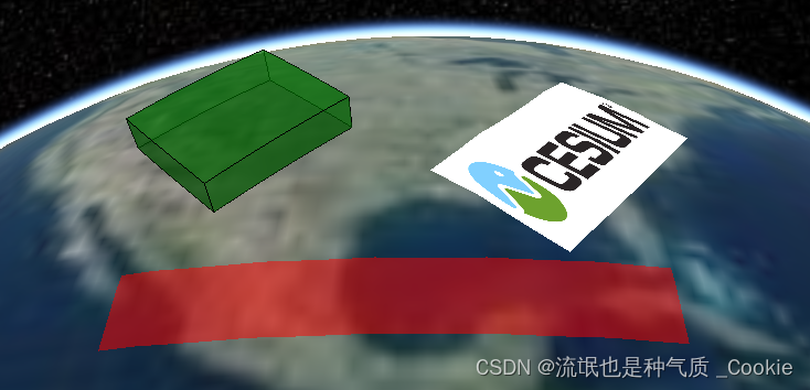
2.效果图
3.代码示例
<!DOCTYPE html>
<html lang="en">
<head>
<meta charset="UTF-8" />
<meta http-equiv="X-UA-Compatible" content="IE=edge" />
<meta name="viewport" content="width=device-width, initial-scale=1.0" />
<title>Document</title>
<link href="https://cesium.com/downloads/cesiumjs/releases/1.114/Build/Cesium/Widgets/widgets.css"
rel="stylesheet" />
<script src="https://unpkg.com/@turf/turf/turf.min.js"></script>
<script src="https://cesium.com/downloads/cesiumjs/releases/1.85/Build/Cesium/Cesium.js"></script>
<script src="https://cdn.staticfile.net/jquery/1.10.2/jquery.min.js"></script>
</head>
<body>
<div id="cesiumContainer"></div>
<script>
//无token会导致球体无法显示
const mapCreate = async () => {
Cesium.Ion.defaultAccessToken ="your_token";
var viewer = new Cesium.Viewer('cesiumContainer', {
geocoder: false,//控制地图是否显示一个地理编码(geocoding)控件,允许用户搜索地点并定位到特定位置。
homeButton: false, //控制是否显示一个回到初始视图的按钮,允许用户快速返回到地图的初始状态
animation: false, //控制是否显示动画控件,允许用户播放、暂停或者改变时间。
fullscreenButton: false, //控制是否显示全屏按钮,允许用户切换地图进入或退出全屏模式。
sceneModePicker: false, //控制是否显示场景模式选择器,允许用户在 2D、3D 和 CV(Columbus View)模式之间切换
timeline: true, //: 控制是否显示时间轴控件,允许用户在时间上浏览数据。
navigationHelpButton: false, //控制是否显示导航帮助按钮,提供关于如何使用地图导航控件的帮助信息
baseLayerPicker: false, // 控制是否显示基础图层选择器,允许用户选择不同的基础图层(如卫星影像、地图等)。
infoBox: false, //控制是否显示信息框,当用户点击地图上的对象时,会显示与该对象相关的信息。
scene3DOnly: false, //如果设置为true,则所有几何图形以3D模式绘制以节约GPU资源
selectionIndicator: false,//控制是否显示选择指示器,用于指示当前选择的地图对象。
baselLayerPicker: false, //控制是否显示基础图层选择器,允许用户选择不同的基础图层。
});
const redRectangle = viewer.entities.add({
name: "Red translucent rectangle",
rectangle: {
coordinates: Cesium.Rectangle.fromDegrees(
-110.0,
20.0,
-80.0,
25.0
),
material: Cesium.Color.RED.withAlpha(0.5),
},
});
const greenRectangle = viewer.entities.add({
name:
"Green translucent, rotated, and extruded rectangle at height with outline",
rectangle: {
coordinates: Cesium.Rectangle.fromDegrees(
-110.0,
30.0,
-100.0,
40.0
),
material: Cesium.Color.GREEN.withAlpha(0.5),
rotation: Cesium.Math.toRadians(45),
extrudedHeight: 300000.0,
height: 100000.0,
outline: true, // height must be set for outline to display
outlineColor: Cesium.Color.BLACK,
},
});
let rotation = Cesium.Math.toRadians(30);
function getRotationValue() {
rotation += 0.005;
return rotation;
}
viewer.entities.add({
name: "Rotating rectangle with rotating texture coordinate",
rectangle: {
coordinates: Cesium.Rectangle.fromDegrees(-92.0, 30.0, -76.0, 40.0),
material: "/Cesium_Logo_Color.jpg",
rotation: new Cesium.CallbackProperty(getRotationValue, false),
stRotation: new Cesium.CallbackProperty(getRotationValue, false),
classificationType: Cesium.ClassificationType.TERRAIN,
},
});
// 点位实体
var pointEntity = viewer.entities.add({
position : Cesium.Cartesian3.fromDegrees(-92.0, 30.0, 40.0),
point : {
pixelSize : 5,
color : Cesium.Color.RED
}
});viewer.zoomTo(viewer.entities);
}
mapCreate()
</script>
</body>
</html>
4.移除实体
viewer.entities.remove(pointEntity); // 移除实体
viewer.entities.removeAll(); // 移除所有实体
移除指定id的实体:
let list = [
                [109.162018, 30.556107],

                [109.153273, 30.554881],

                [109.150425, 30.561759],

                [109.139546, 30.57109],

                [109.14245, 30.574852],

                [109.152813, 30.57898]
            ]
            list.forEach((item, index) => {
                let layerId = null, color = null;

                if (index <= 2) {
                    layerId = "myEntityId" + index // 这里定义实体的ID
                    color = Cesium.Color.RED
                } else {
                    layerId = "customId" + index
                    color = new Cesium.Color(0.0, 0.0, 1.0, 1.0)
                }
                myEntity = new Cesium.Entity({

                    id: layerId,
                    position: Cesium.Cartesian3.fromDegrees(item[0], item[1]), // 位置
                    point: { // 点实体的样式
                        pixelSize: 10,
                        color: color,
                        outlineColor: Cesium.Color.WHITE,
                        outlineWidth: 2
                    }
                });
                viewer.entities.add(myEntity);
            });


            viewer.zoomTo(viewer.entities);

            // 要移除的ID部分
            var idToMatch = "myEntityId";

            // 创建一个临时的实体集合用于存储要移除的实体
            var entitiesToRemove = new Cesium.EntityCollection();

            // 遍历现有的实体集合
            viewer.entities.values.forEach(function (entity) {
                // 检查实体ID是否包含特定字符串
                if (entity.id && entity.id.includes(idToMatch)) {
                    // 添加到待移除的实体集合中
                    entitiesToRemove.add(entity);
                }
            });

            // 从原始实体集合中移除这些实体
            entitiesToRemove.values.forEach(function (entity) {
                viewer.entities.remove(entity);
            });


 1187
1187

 被折叠的 条评论
为什么被折叠?
被折叠的 条评论
为什么被折叠?
 到【灌水乐园】发言


