


在上个版本Qt quick-QML地图引擎之v4版本(新增3D模型/高德/谷歌在线/离线预览/多线程离线裁剪下载/区域查询/位置搜索/路径规划)_qt 高德地图离线_诺谦的博客-CSDN博客更新了很多小功能。经过朋友们一致需求建议,所以V4继续优化。
链接:https://pan.baidu.com/s/1DdqZGEhfKjiN-rzbdu8Akg?pwd=9wwd
提取码:9wwd
B站视频: Qt Quick-QML地图引擎之v4版本(新增3D模型/抗锯齿下载优化)_哔哩哔哩_bilibili
GIF如下所示:
1.新增ArcGIS街道(蓝黑)-在线和离线下载

2.多边形下载-抗锯齿
V3旧版本裁剪后的如下图所示:

V4版本裁剪后的如下图所示:

增加抗锯齿后,裁剪明显没有锯齿了。
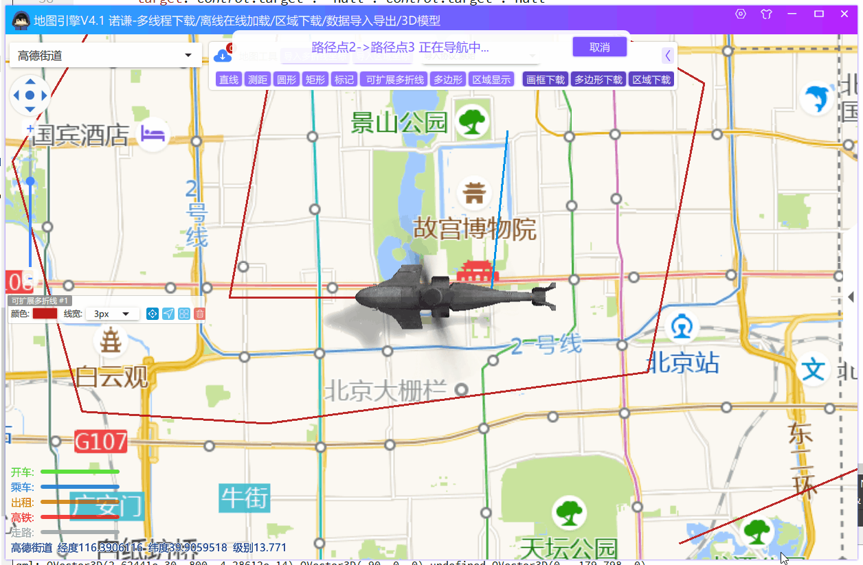
3.3D模型
但是由于Qt地图常常用于嵌入式系统,或者就是无人机系统,需要实时展示物体/飞行器实时姿态和经纬度,由于市面上QT的大部分都是2D物体模拟,比如:

所以V4增加3D模型实现,这样就可以显示具体的姿态信息,这样更加地直观,欧拉角姿态如下图所示:

截图如下所示:

支持各种倾斜、旋转、纠正视角:

支持跨平台、Linux/嵌入式/mac一键编译:

也可以支持显示四轴无人机、雷达等等各种3D模型、
由于本人没有实际设备获取,所以数据通过轨迹线模拟生成的,模拟代码如下所示:
    // 启动导航 list<coordinate>
    function startNavigator(pathData) {
        editEnable = false
        navigationLine.path = []
        navigationTimer.path = pathData
        navigationTimer.currentIdx = 0
        navigationTimer.initializedData(true);
        navigationTimer.restart()
        navigatorHintPopup.open();      // 提示
    }

    Timer {
        id: navigationTimer
        interval: 200
        running: false
        repeat: true

        property var path           // 路径
        property int currentIdx     // 当前到哪个路径
        property real arc           // 弧点
        property var end            // 结束点
        property var begin          // 起始点
        property var current        // 当前点
        property int currentStepCnt: 0

        property real longStep      // 步数
        property real latStep

        property bool longAdd       // 增减关系
        property bool latAdd

        onTriggered: {

            currentStepCnt+=1

            current.latitude = currentStepCnt*latStep + navigationTimer.begin.latitude
            current.longitude = currentStepCnt*longStep + navigationTimer.begin.longitude


            let intervalY = latAdd ? current.latitude - end.latitude : end.latitude - current.latitude;
            let intervalX = longAdd ? current.longitude - end.longitude : end.longitude - current.longitude;

            if(intervalX>0 || intervalY>0) {
                target.center = end
                current = end

                navigation3DModel.nextCoordinate(current)
                navigationLine.replaceCoordinate(currentIdx,current)

                if((currentIdx+1) >= navigationTimer.path.length) {
                    navigationTimer.stop();
                    navigatorHintPopup.close();
                    editEnable = true
                } else {
                    initializedData();
                    let less = Math.sqrt(Math.pow(intervalY,2) + Math.pow(intervalX,2))

                    navigationTimer.begin.longitude += less * Math.cos(navigationTimer.arc)
                    navigationTimer.begin.latitude += less * Math.sin(navigationTimer.arc)
                    navigation3DModel.nextCoordinate(navigationTimer.begin)

                }

            } else {
                target.center = current
                navigation3DModel.nextCoordinate(current)

                if(navigation3DModel.visible)
                  navigationLine.replaceCoordinate(currentIdx, navigation3DModel.coordinate)
            }
        }

        // 初始化数据
        function initializedData(first = false) {

            navigationTimer.begin = navigationTimer.path[currentIdx];
            let end = navigationTimer.path[currentIdx+1];

            let arc = Math.atan2((end.latitude - navigationTimer.begin.latitude), (end.longitude - navigationTimer.begin.longitude));

            navigationTimer.longStep = navigatorSpeed * Math.cos(arc)
            navigationTimer.latStep = navigatorSpeed * Math.sin(arc)

            navigationTimer.longAdd =  navigationTimer.longStep > 0 ? true : false
            navigationTimer.latAdd =  navigationTimer.latStep > 0 ? true : false

            navigationTimer.currentStepCnt = 0

            console.log("开始导航", currentIdx, end.longitude , end.latitude , begin.longitude, begin.latitude)

            navigationTimer.current = navigationTimer.begin
            navigationTimer.end = end
            navigationTimer.arc = arc
            if(currentIdx == 0) navigationLine.addCoordinate(navigationTimer.begin)
            navigationLine.addCoordinate(navigationTimer.begin)

            navigation3DModel.initCoordinate(navigationTimer.begin, end, first)

            currentIdx += 1
            navigatorHintPopup.label = `路径点${currentIdx}->路径点${currentIdx+1} 正在导航中...`;      // 提示

        }
    }
2023/06/06 - 离线地图加载- 增加支持多个离线地图厂家

支持加密和非加密,并且加密和非加密加载速度一样的,如下图所示,使用加密后的离线文件数据:

2024/02/29 - 绘制工具新增抗锯齿
之前版本:

优化后:


 615
615

 被折叠的 条评论
为什么被折叠?
被折叠的 条评论
为什么被折叠?
 到【灌水乐园】发言


