


概要
小工具(TypeScript+Vue3),可生成指定数量的网格状GeoJson格式矢量面(Polygon)数据,属性包括name、color、rotation、opacity等(随机值)。
核心代码
<script setup lang="ts">
import { onMounted, ref } from "vue"

// GeoJson对象
let geo = ref({
	type: "FeatureCollection",
	features: []
})
const startPoint = [100, 40] // 网格起点(左上角)
const areaSize = 10  // 网格宽度(度)
const cellSize = 0.1  // 格子宽度(度)

// 入口
function start() {
	// 网格数据
	const grid = generateGrid(startPoint, areaSize);
	// format网格
	grid.forEach(creatGeo)
	// 下载数据
	downloadFile(geo.value)
}

// 创建网格
function generateGrid(startPoint: number[], areaSize: number) {
	const grid: number[][][] = [];
	const startX = startPoint[0];
	const startY = startPoint[1];
	// 计算网格的行数和列数
	const rows = Math.ceil(areaSize / cellSize);
	const columns = Math.ceil(areaSize / cellSize);
	// 生成每个格子的顶点坐标
	for (let row = 0; row < rows; row++) {
		for (let col = 0; col < columns; col++) {
			const x1: number = startX + col * cellSize;
			const y1: number = startY - row * cellSize;
			const x2: number = x1 + cellSize;
			const y2: number = y1 - cellSize;
			grid.push([
				[x1, y1],
				[x1, y2],
				[x2, y2],
				[x2, y1],
				[x1, y1]
			]);
		}
	}
	return grid;
}

// 数据处理
function creatGeo(coordinates: number[][]) {
	// 旋转,精确到 2 位小数
	const rotation = parseFloat((Math.random()).toFixed(2))
	// 透明度,精确到 1 位小数
	const opacity = parseFloat(Math.random().toFixed(1))
	// 随机名称
	function generateRandomName() {
		const adjectives = ["Big", "Small", "Crazy", "Brave", "Wild", "Gentle", "Silly", "Happy", "Lucky", "Wise"];
		const nouns = ["Elephant", "Tiger", "Lion", "Monkey", "Dolphin", "Kangaroo", "Giraffe", "Penguin", "Owl", "Turtle"];
		const randomAdjective = adjectives[Math.floor(Math.random() * adjectives.length)];
		const randomNoun = nouns[Math.floor(Math.random() * nouns.length)];
		return randomAdjective + " " + randomNoun;
	}
	const name = generateRandomName();
	// 随机颜色
	function getRandomColor() {
		const letters = "0123456789ABCDEF";
		let color = "#";
		for (let i = 0; i < 6; i++) {
			color += letters[Math.floor(Math.random() * 16)];
		}
		return color;
	}
	const color = getRandomColor()

	let obj = {
		"type": "Feature",
		"properties": {
			"rotation": rotation,
			"name": name,
			"opacity": opacity,
			"color": color
		},
		"geometry": {
			"coordinates": [coordinates],
			"type": "Polygon"
		}
	}
	geo.value.features.push(obj)
}

// 下载数据
function downloadFile(json: any) {
	let jsonString = JSON.stringify(json)
	// 创建Blob 对象
	var blob = new Blob([jsonString], { type: "application/json" });
	// 创建下载链接
	var downloadLink = document.createElement("a");
	downloadLink.href = URL.createObjectURL(blob);
	downloadLink.download = "geoJson.json";
	// 链接下载
	document.body.appendChild(downloadLink);
	downloadLink.click();
	// 清理链接
	document.body.removeChild(downloadLink);
}
onMounted(() => {
	start()
})
</script>
数据样例:
{
    "type": "FeatureCollection",
    "features": [
        {
            "type": "Feature",
            "properties": {
                "rotation": 0.47,
                "name": "Wild Owl",
                "opacity": 0.3,
                "color": "#BC75AF"
            },
            "geometry": {
                "coordinates": [
                    [
                        [100, 40],
                        [100,39.9],
                        [100.1,39.9],
                        [100.1,40],
                        [100,40]
                    ]
                ],
                "type": "Polygon"
            }
        }
    ]
}
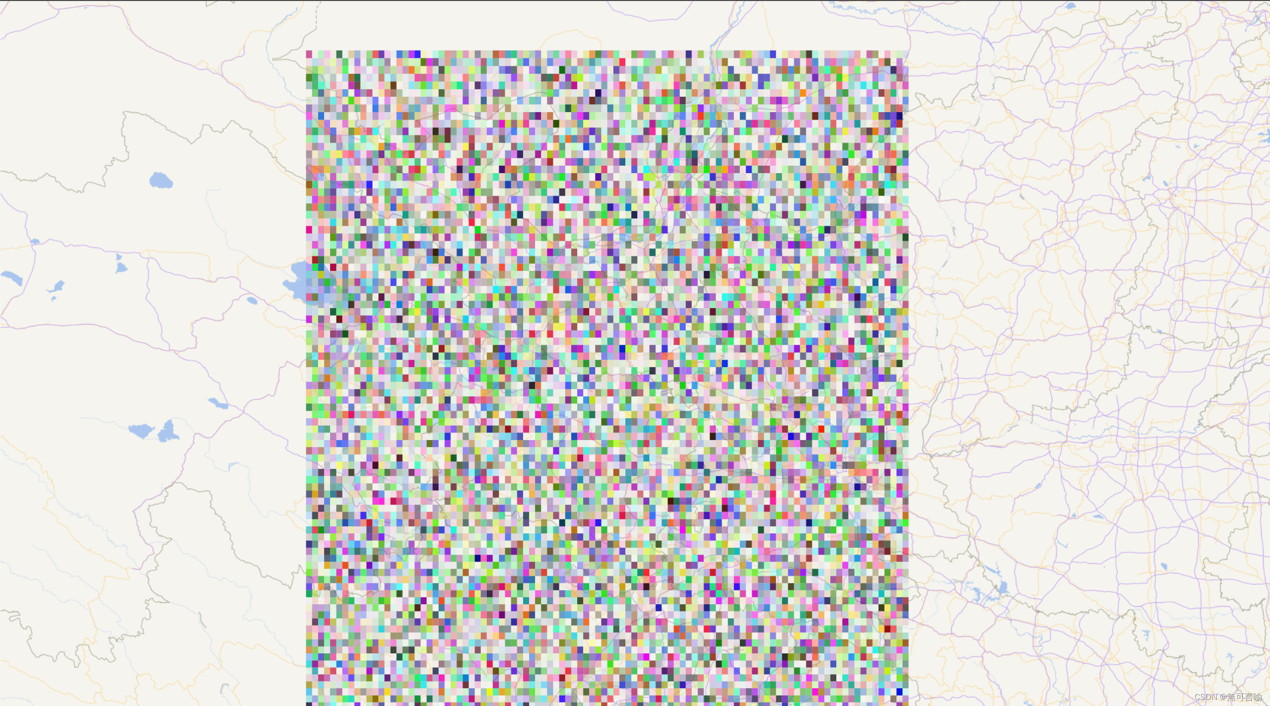
加载效果:
下载地址(包含1W、25W网格状矢量面的GeoJson文件):
https://download.csdn.net/download/qq_40236953/88632379
写在最后:
在使用平面投影坐标系(如Web墨卡托投影)时,经纬度坐标被映射到平面上,这个过程会引起形变。在高纬度地区,尤其是在极地附近,经线(纵向)会收缩,导致小格子形变为长方形。而在低纬度地区,经线比较接近平行,在平面投影中形变相对较小,小格子基本保持正方形。


 1万+
1万+


 被折叠的 条评论
为什么被折叠?
被折叠的 条评论
为什么被折叠?
 到【灌水乐园】发言


