


最近在研究加载第三方的地图,由于作者是小白昨天整花了一天的事件无法把网上给的东西加载出来,这里首先要了解Dojo前端框架,这款js框架是模块化编程,可以有点类似C#的类库,本文从https://blog.csdn.net/gisshixisheng/article/details/44494715学习很多,但是一直无法调试成功,最终调试成功进行过程详细的剖析。
一、首先了解Dojo模块的定义(这里定义moudle1的模块这个是一个单独的文件)
//该模块提供了一个方法,可以改变dom元素的innerHTML
define(["dojo/dom"], function(dom) {
        return {
            change: function(id,text) {
                dom.byId(id).innerHTML=text
            }
        }
    }
);
在HTML页面中的引用格式
<script>
        var dojoConfig={
            packages: [{
                name: "js",//模块的名字
                location: location.pathname.replace(/\/[^/]*$/, '') + '/js'//模块所处的路径
            }]
        }
</script>
Note:这里js是一个文件夹,刚才定义的模块的js文件包含里面
在require中添加引用
require(["js/moudle1"], function(moudle1) {
            moudle1.change("test1","文本改变了moudle3")
        });
二、定义一个图层模块
(1)定义BDAnoLayer模块
define(["dojo/_base/declare",
    "esri/layers/tiled"],
    function (declare) {
        return declare(esri.layers.TiledMapServiceLayer, {
            constructor: function () {
                this.spatialReference = new esri.SpatialReference({ wkid: 102100 });
                this.initialExtent = (this.fullExtent = new esri.geometry.Extent(-20037508.3427892, -20037508.3427892, 20037508.3427892, 20037508.3427892, this.spatialReference));
                this.scale = [591657527.591555, 295828763.795777, 147914381.897889, 73957190.948944, 36978595.474472, 18489297.737236, 9244648.868618,
                    4622324.434309, 2311162.217155, 1155581.108577, 577790.554289, 288895.277144, 144447.638572, 72223.819286,
                    36111.9096437, 18055.9548224, 9027.977411, 4513.988705, 2256.994353, 1128.497176];
                this.resolution = [156543.033928, 78271.5169639999, 39135.7584820001, 19567.8792409999, 9783.93962049996, 4891.96981024998, 2445.98490512499,
                    1222.99245256249, 611.49622628138, 305.748113140558, 152.874056570411, 76.4370282850732, 38.2185141425366, 19.1092570712683, 9.55462853563415,
                    4.77731426794937, 2.38865713397468, 1.19432856685505, 0.597164283559817, 0.298582141647617];
                this.tileInfo = new esri.layers.TileInfo({
                    "rows": 256,
                    "cols": 256,
                    "compressionQuality": 90,
                    "origin": {
                        "x": -20037508.3427892,
                        "y": 20037508.3427892
                    },
                    "spatialReference": this.spatialReference,
                    "lods": [{ "level": 0, "resolution": this.resolution[0], "scale": this.scale[0] },
                        { "level": 1, "resolution": this.resolution[1], "scale": this.scale[1] },
                        { "level": 2, "resolution": this.resolution[2], "scale": this.scale[2] },
                        { "level": 3, "resolution": this.resolution[3], "scale": this.scale[3] },
                        { "level": 4, "resolution": this.resolution[4], "scale": this.scale[4] },
                        { "level": 5, "resolution": this.resolution[5], "scale": this.scale[5] },
                        { "level": 6, "resolution": this.resolution[6], "scale": this.scale[6] },
                        { "level": 7, "resolution": this.resolution[7], "scale": this.scale[7] },
                        { "level": 8, "resolution": this.resolution[8], "scale": this.scale[8] },
                        { "level": 9, "resolution": this.resolution[9], "scale": this.scale[9] },
                        { "level": 10, "resolution": this.resolution[10], "scale": this.scale[10] },
                        { "level": 11, "resolution": this.resolution[11], "scale": this.scale[11] },
                        { "level": 12, "resolution": this.resolution[12], "scale": this.scale[12] },
                        { "level": 13, "resolution": this.resolution[13], "scale": this.scale[13] },
                        { "level": 14, "resolution": this.resolution[14], "scale": this.scale[14] },
                        { "level": 15, "resolution": this.resolution[15], "scale": this.scale[15] },
                        { "level": 16, "resolution": this.resolution[16], "scale": this.scale[16] },
                        { "level": 17, "resolution": this.resolution[17], "scale": this.scale[17] },
                        { "level": 18, "resolution": this.resolution[18], "scale": this.scale[18] },
                        { "level": 19, "resolution": this.resolution[19], "scale": this.scale[19] }
                    ]
                });
                this.loaded = true;
                this.onLoad(this);
            },
            getTileUrl: function (level, row, col) {
                var zoom = level - 1;
                var offsetX = parseInt(Math.pow(2, zoom));
                var offsetY = offsetX - 1;
                var numX = col - offsetX, numY = (-row) + offsetY;
                var num = (col + row) % 8 + 1;
                return "http://online" + num + ".map.bdimg.com/tile/?qt=tile&x=" + numX + "&y=" + numY + "&z=" + level + "&styles=sl&udt=20141015";
            }
        });
});define(["dojo/_base/declare",
"esri/layers/tiled"],
function (declare) {
return declare(esri.layers.TiledMapServiceLayer, {
constructor: function () {
this.spatialReference = new esri.SpatialReference({ wkid: 102100 });
this.initialExtent = (this.fullExtent = new esri.geometry.Extent(-20037508.3427892, -20037508.3427892, 20037508.3427892, 20037508.3427892, this.spatialReference));
this.scale = [591657527.591555, 295828763.795777, 147914381.897889, 73957190.948944, 36978595.474472, 18489297.737236, 9244648.868618,
4622324.434309, 2311162.217155, 1155581.108577, 577790.554289, 288895.277144, 144447.638572, 72223.819286,
36111.9096437, 18055.9548224, 9027.977411, 4513.988705, 2256.994353, 1128.497176];
this.resolution = [156543.033928, 78271.5169639999, 39135.7584820001, 19567.8792409999, 9783.93962049996, 4891.96981024998, 2445.98490512499,
1222.99245256249, 611.49622628138, 305.748113140558, 152.874056570411, 76.4370282850732, 38.2185141425366, 19.1092570712683, 9.55462853563415,
4.77731426794937, 2.38865713397468, 1.19432856685505, 0.597164283559817, 0.298582141647617];
this.tileInfo = new esri.layers.TileInfo({
"rows": 256,
"cols": 256,
"compressionQuality": 90,
"origin": {
"x": -20037508.3427892,
"y": 20037508.3427892
},
"spatialReference": this.spatialReference,
"lods": [{ "level": 0, "resolution": this.resolution[0], "scale": this.scale[0] },
{ "level": 1, "resolution": this.resolution[1], "scale": this.scale[1] },
{ "level": 2, "resolution": this.resolution[2], "scale": this.scale[2] },
{ "level": 3, "resolution": this.resolution[3], "scale": this.scale[3] },
{ "level": 4, "resolution": this.resolution[4], "scale": this.scale[4] },
{ "level": 5, "resolution": this.resolution[5], "scale": this.scale[5] },
{ "level": 6, "resolution": this.resolution[6], "scale": this.scale[6] },
{ "level": 7, "resolution": this.resolution[7], "scale": this.scale[7] },
{ "level": 8, "resolution": this.resolution[8], "scale": this.scale[8] },
{ "level": 9, "resolution": this.resolution[9], "scale": this.scale[9] },
{ "level": 10, "resolution": this.resolution[10], "scale": this.scale[10] },
{ "level": 11, "resolution": this.resolution[11], "scale": this.scale[11] },
{ "level": 12, "resolution": this.resolution[12], "scale": this.scale[12] },
{ "level": 13, "resolution": this.resolution[13], "scale": this.scale[13] },
{ "level": 14, "resolution": this.resolution[14], "scale": this.scale[14] },
{ "level": 15, "resolution": this.resolution[15], "scale": this.scale[15] },
{ "level": 16, "resolution": this.resolution[16], "scale": this.scale[16] },
{ "level": 17, "resolution": this.resolution[17], "scale": this.scale[17] },
{ "level": 18, "resolution": this.resolution[18], "scale": this.scale[18] },
{ "level": 19, "resolution": this.resolution[19], "scale": this.scale[19] }
]
});
this.loaded = true;
this.onLoad(this);
},
getTileUrl: function (level, row, col) {
var zoom = level - 1;
var offsetX = parseInt(Math.pow(2, zoom));
var offsetY = offsetX - 1;
var numX = col - offsetX, numY = (-row) + offsetY;
var num = (col + row) % 8 + 1;
return "http://shangetu" + num + ".map.bdimg.com/it/u=x=" + numX + ";y=" + numY + ";z=" + level + ";v=009;type=sate&fm=46&udt=20141015";
}
});
});(3)定义BDVecLayer模块
define(["dojo/_base/declare",
    "esri/layers/tiled"],
    function (declare) {
        return declare(esri.layers.TiledMapServiceLayer, {
            constructor: function () {
                this.spatialReference = new esri.SpatialReference({ wkid: 102100 });
                this.initialExtent = (this.fullExtent = new esri.geometry.Extent(-20037508.3427892, -20037508.3427892, 20037508.3427892, 20037508.3427892, this.spatialReference));
                this.scale = [591657527.591555, 295828763.795777, 147914381.897889, 73957190.948944, 36978595.474472, 18489297.737236, 9244648.868618,
                    4622324.434309, 2311162.217155, 1155581.108577, 577790.554289, 288895.277144, 144447.638572, 72223.819286,
                    36111.9096437, 18055.9548224, 9027.977411, 4513.988705, 2256.994353, 1128.497176];
                this.resolution = [156543.033928, 78271.5169639999, 39135.7584820001, 19567.8792409999, 9783.93962049996, 4891.96981024998, 2445.98490512499,
                    1222.99245256249, 611.49622628138, 305.748113140558, 152.874056570411, 76.4370282850732, 38.2185141425366, 19.1092570712683, 9.55462853563415,
                    4.77731426794937, 2.38865713397468, 1.19432856685505, 0.597164283559817, 0.298582141647617];
                this.tileInfo = new esri.layers.TileInfo({
                    "rows": 256,
                    "cols": 256,
                    "compressionQuality": 90,
                    "origin": {
                        "x": -20037508.3427892,
                        "y": 20037508.3427892
                    },
                    "spatialReference": this.spatialReference,
                    "lods": [{ "level": 0, "resolution": this.resolution[0], "scale": this.scale[0] },
                        { "level": 1, "resolution": this.resolution[1], "scale": this.scale[1] },
                        { "level": 2, "resolution": this.resolution[2], "scale": this.scale[2] },
                        { "level": 3, "resolution": this.resolution[3], "scale": this.scale[3] },
                        { "level": 4, "resolution": this.resolution[4], "scale": this.scale[4] },
                        { "level": 5, "resolution": this.resolution[5], "scale": this.scale[5] },
                        { "level": 6, "resolution": this.resolution[6], "scale": this.scale[6] },
                        { "level": 7, "resolution": this.resolution[7], "scale": this.scale[7] },
                        { "level": 8, "resolution": this.resolution[8], "scale": this.scale[8] },
                        { "level": 9, "resolution": this.resolution[9], "scale": this.scale[9] },
                        { "level": 10, "resolution": this.resolution[10], "scale": this.scale[10] },
                        { "level": 11, "resolution": this.resolution[11], "scale": this.scale[11] },
                        { "level": 12, "resolution": this.resolution[12], "scale": this.scale[12] },
                        { "level": 13, "resolution": this.resolution[13], "scale": this.scale[13] },
                        { "level": 14, "resolution": this.resolution[14], "scale": this.scale[14] },
                        { "level": 15, "resolution": this.resolution[15], "scale": this.scale[15] },
                        { "level": 16, "resolution": this.resolution[16], "scale": this.scale[16] },
                        { "level": 17, "resolution": this.resolution[17], "scale": this.scale[17] },
                        { "level": 18, "resolution": this.resolution[18], "scale": this.scale[18] },
                        { "level": 19, "resolution": this.resolution[19], "scale": this.scale[19] }
                    ]
                });
                this.loaded = true;
                this.onLoad(this);
            },
            getTileUrl: function (level, row, col) {
                var zoom = level - 1;
                var offsetX = parseInt(Math.pow(2, zoom));
                var offsetY = offsetX - 1;
                var numX = col - offsetX, numY = (-row) + offsetY;
                var num = (col + row) % 8 + 1;
                return "http://online" + num + ".map.bdimg.com/tile/?qt=tile&x=" + numX + "&y=" + numY + "&z=" + level + "&styles=pl&scaler=1&udt=20141103";
            }
        });
    });
三、在HTML中汇总
<!DOCTYPE html>
<html>
<head>
<meta http-equiv="Content-Type" content="text/html; charset=utf-8" />
<title>Baidu Map</title>
<link rel="stylesheet" type="text/css" href="https://js.arcgis.com/3.21/esri/css/esri.css" />
<link rel="stylesheet" type="text/css" href="https://js.arcgis.com/3.21/dijit/themes/tundra/tundra.css" />
<script src="../Scripts/jquery-1.10.2.js"></script>
<script type="text/javascript">
var dojoConfig = {
async: false,//注意这个参数不能缺少,要设置False
parseOnLoad: true,
packages: [{ //解释:require(["js/.."],function(){}) 中 js/ 即为 location的值
name: "bdlib", //对应require引用包里的js
location: location.pathname.replace(/\/[^/]+$/, "") + "/bdlib" //对应的路径
}]
};
</script>
<script type="text/javascript" src="https://js.arcgis.com/3.21"></script>//一定要在引用包后面添加
<!--<script src="/bdlib/BDAnoLayer.js"></script>
<script src="/bdlib/BDimgLayer.js"></script>
<script src="/bdlib/JavaScript.js"></script>-->
<style>
html, body, #map {
height: 100%;
margin: 0;
padding: 0;
}
.base-map-ano {
position: absolute;
right: 0pt;
top: 18pt;
background: #e6edf1;
border: #96aed1 1px solid;
padding: 4px 5px;
padding-left: 0px;
padding-top: 0px;
display: none;
font-weight: normal;
}
.base-map {
position: absolute;
right: 15pt;
top: 15pt;
background: #f0f0f0;
border: #96aed1 1px solid;
width: auto;
height: auto;
z-index: 99;
font: normal 11px "宋体",Arial;
color: #868686;
}
.base-map-switch {
padding: 4px 8px;
float: left;
}
.base-map-switch-active {
background: #e6edf1;
font-weight: bold;
color: #4d4d4d;
}
.base-map-switch:hover {
cursor: pointer;
}
.base-map-switch-center {
border: 1px #96aed1 solid;
border-top: none;
border-bottom: none;
}
</style>
<script>
var map,showMap,anoCtrl;
require(["esri/map",
"bdlib/BDVecLayer",
"bdlib/BDImgLayer",
"bdlib/BDAnoLayer",
"esri/layers/FeatureLayer",
"esri/geometry/Point",
"esri/SpatialReference",
"dojo/domReady!"],
function (Map,
BDVecLayer,
BDImgLayer,
BDAnoLayer,
FeatureLayer,
Point,
SpatialReference
){
map = new Map("map", {
logo: false
});
var vecMap = new BDVecLayer();
var imgMap = new BDImgLayer();
var anoMap = new BDAnoLayer();
map.addLayer(vecMap);
map.addLayers([imgMap,anoMap]);
imgMap.hide();
anoMap.hide();
var pt = new Point(7038512.810510807, 2629489.7975553474, new SpatialReference({ wkid: 102100 }));
map.centerAndZoom(pt, 5);
showMap = function(layer){
//设置按钮样式
var baseMap = ["vec","img"];
for(var i= 0, dl=baseMap.length;i<dl;i++){
$("#"+baseMap[i]).removeClass("base-map-switch-active");
}
$("#"+layer).addClass("base-map-switch-active");
//设置显示地图
switch(layer){
case "img":{//影像
vecMap.hide();
imgMap.show();
$("#ano").show();
break;
}
default :{//地图
vecMap.show();
imgMap.hide();
anoMap.hide();
$("#ano").hide();
$("#chkAno").attr("checked",false);
break;
}
}
};
anoCtrl = function(){
if($("#chkAno").prop("checked")){
anoMap.show();
}
else{
anoMap.hide();
}
}
});
</script>
</head>
<body>
<div id="map">
<div class="base-map">
<div id="vec" class="base-map-switch base-map-switch-active" οnclick="showMap('vec')">地图</div>
<div id="img" class="base-map-switch base-map-switch-center" οnclick="showMap('img')">
影像
<div id="ano" class="base-map-ano">
<input id="chkAno" type="checkbox" name="chkAno" value="chkAno" οnchange="anoCtrl()" />标注
</div>
</div>
</div>
</div>
</body>
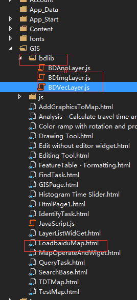
</html>四、文件布局
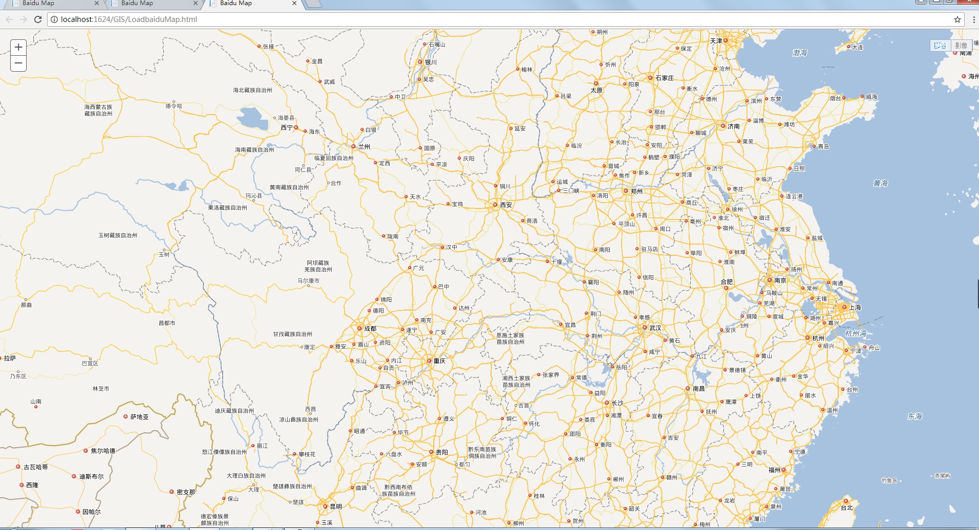
五、效果图展示


 2720
2720


 被折叠的 条评论
为什么被折叠?
被折叠的 条评论
为什么被折叠?
 到【灌水乐园】发言


