


 文章描述了如何在Vue项目中使用uni-app的内置地图组件,实现地理位置定位、标记点添加、路径线绘制以及区域的绘制功能,包括使用`uni.createMapContext`和组件交互的方法。
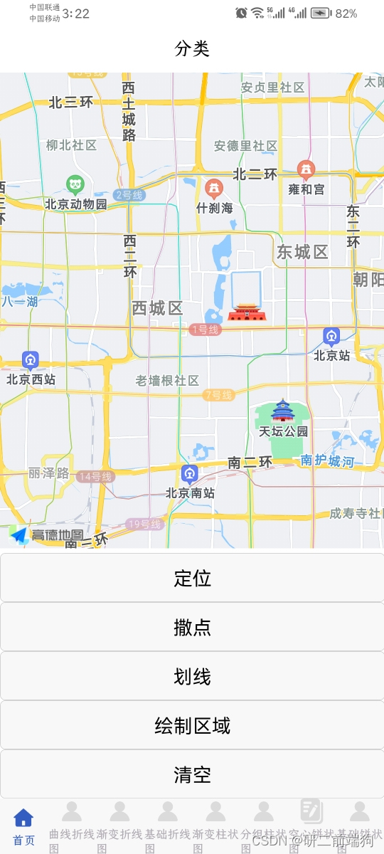
本部分采用自带map组件进行。
实现效果:
<template>
	<view>
		<map id="test_map" ref="map1" style="width: 100%; height: 600px" :show-location="true"
			:longitude="map.longitude" :latitude="map.latitude" :markers="markers" :polyline="polyline"
			show-compass="true" :polygons="polygons" :controls="controls" @tap="tapMap">

		</map>
		<button @click="position(39.894589, 116.32125)">定位</button>
		<button @click="point">撒点</button>
		<button @click="line">划线</button>
		<button @click="area">绘制区域</button>
		<button @click="doDelete">清空</button>
	</view>
</template>
<script>
	export default {

		data() {
			return {
				//绘制区域
				polygons: [],
				//区域点lsit
				option: [{
						longitude: 115.52125,
						latitude: 39.794587,
					},
					{
						longitude: 114.02125,
						latitude: 39.594581,
					},
					{
						longitude: 116.72125,
						latitude: 39.294585,
					}
				],
				mapContext: {},
				map: {
					longitude: "", //经度
					latitude: "", //纬度
				},
				//线数据
				polyline: [],
				//点数据list
				pointList: [{
						longitude: 115.52125,
						latitude: 39.794587,
					},
					{
						longitude: 114.02125,
						latitude: 39.594581,
					},
					{
						longitude: 119.72125,
						latitude: 39.294585,
					},
				],
				controls: [],
				//撒点list
				markers: [],
			};
		},
		created() {
			let _this = this;
			// if (this.getLocation != null) {
			// 	_this.map.longitude = this.getLocation.longitude;
			// 	_this.map.latitude = this.getLocation.latitude;

			// 	return;
			// }
		},
		mounted() {
			this.mapContext = uni.createMapContext("test_map", this);
		},
		methods: {
			//撒点
			point() {
				// 遍历 polyline 中的每个点,并添加到地图上
				this.pointList.forEach(point => {
					this.addPoint(point.latitude, point.longitude);
				});
			},
			//描点
			addPoint(latitude, longitude) {
				let point = {
					id: this.markers.length + 1, // 自动增加 id
					width: 40, //宽
					height: 40, //长
					latitude: latitude,
					longitude: longitude,
					iconPath: "/static/default.png", // 使用默认定位图标
					anchor: {
						x: 0.5,
						y: 1,
					},
				};
				this.markers.push(point);
			},
			//划线
			line() {
				// 更新 polyline 数组
				this.polyline = [{
					points: [{
							longitude: 116.52125,
							latitude: 39.794587,
						},
						{
							longitude: 116.02125,
							latitude: 39.594581,
						},
						{
							longitude: 116.72125,
							latitude: 39.294585,
						}
					],
					color: "#ff0f0f",
					width: 10,
					dottedLine: true,
					arrowLine: true,
					colorList: true,
				}];

			},
			//绘制区域
			area() {
				// 点线面,如果不是面就不让他生成
				if (this.option.length > 2) {
					this.polygons = [{
						strokeWidth: 1,
						strokeColor: '#67c23a',
						fillColor: '#1791fc66',
						dottedLine: false,
						arrowLine: false,
						level: "abovelabels",
						points: this.option
					}];
					this.polygons[0].points = [];
					this.polygons[0].points.push(...this.option)

				} else {
					uni.showToast({
						title: "起码选择三个点",
						duration: 2000,

						icon: 'error',
					})
				}


			},
			tapMap(e) {
				var that = this;
				var id = e.currentTarget.id;
				var maps = uni.createMapContext("test_map", this).$getAppMap();

				maps.onclick = function(point) {
					console.log(point);

					point.iconPath = "/static/default.png";
					that.markers = that.markers.concat(point);

					uni.showToast({
						title: "添加成功",
						icon: "none",
					});
				};
			},
			//定位
			position(latitude, longitude) {
				this.mapContext.moveToLocation({
					latitude: latitude,
					longitude: longitude,
					success: (res) => {
						console.log('撒点')

						this.addPoint(latitude, longitude);
					},
				});
				// ref定位
				// this.$refs.map1.moveToLocation({
				// 		latitude: 39.894589,
				// 		longitude: 116.32125,
				// 	},
				// 	function(res) {
				// 		console.log("此处无回调!!!本条信息未在控制台打印");
				// 		console.log(res);
				// 	}
				// );
			},
			doDelete() {
				//清空区域
				this.polygons = [],
					// 清空点
					this.markers = [],
					// 清空线
					this.polyline = []
			}

		},
	};
</script>
<style>

</style>
关于定位的function,我又进行了修改和优化。
		// 选择位置
			chooseLocation() {
				uni.showLoading({
					title: '获取信息中'
				});
				uni.getLocation({
					type: 'gcj02',
					success: (res) => {
						this.setMap(res);
						uni.hideLoading(); // 获取位置信息成功后隐藏加载指示器
					},
					fail: (error) => {
						console.error('获取位置信息失败', error);
						uni.showToast({
							title: '获取位置信息失败',
							icon: 'none'
						});
						uni.hideLoading(); // 获取位置信息失败后隐藏加载指示器
					}
				});
			},
			// 设置地图
			setMap(item) {
				this.markers = [{
					latitude: item.latitude,
					longitude: item.longitude,
				}];
				this.mapContext.moveToLocation({
					latitude: item.latitude,
					longitude: item.longitude,
					success: () => {
						this.addPoint(item.latitude, item.longitude);
					},
				});
			}
完整代码如下
<template>
	<view>
		<map id="test_map" ref="map1" style="width: 100%; height: 600px" :show-location="true"
			:longitude="map.longitude" :latitude="map.latitude" :markers="markers" :polyline="polyline"
			show-compass="true" :polygons="polygons" :controls="controls" @tap="tapMap">

		</map>
		<!-- '	<button @click="position(39.894589, 116.32125)">定位</button>' -->

		<button @click="chooseLocation">定位</button>
		<button @click="point">撒点</button>
		<button @click="line">划线</button>
		<button @click="area">绘制区域</button>
		<button @click="doDelete">清空</button>
	</view>
</template>
<script>
	export default {

		data() {
			return {
				//绘制区域
				polygons: [],
				//区域点lsit
				option: [{
						longitude: 115.52125,
						latitude: 39.794587,
					},
					{
						longitude: 114.02125,
						latitude: 39.594581,
					},
					{
						longitude: 116.72125,
						latitude: 39.294585,
					}
				],
				mapContext: {},
				map: {
					longitude: "", //经度
					latitude: "", //纬度
				},
				//线数据
				polyline: [],
				//点数据list
				pointList: [{
						longitude: 115.52125,
						latitude: 39.794587,
					},
					{
						longitude: 114.02125,
						latitude: 39.594581,
					},
					{
						longitude: 119.72125,
						latitude: 39.294585,
					},
				],
				controls: [],
				//撒点list
				markers: [],
			};
		},
		created() {
			let _this = this;
			// if (this.getLocation != null) {
			// 	_this.map.longitude = this.getLocation.longitude;
			// 	_this.map.latitude = this.getLocation.latitude;

			// 	return;
			// }
		},
		mounted() {
			this.mapContext = uni.createMapContext("test_map", this);
		},
		methods: {
			//撒点
			point() {
				// 遍历 polyline 中的每个点,并添加到地图上
				this.pointList.forEach(point => {
					this.addPoint(point.latitude, point.longitude);
				});
			},
			//描点
			addPoint(latitude, longitude) {
				let point = {
					id: this.markers.length + 1, // 自动增加 id
					width: 40, //宽
					height: 40, //长
					latitude: latitude,
					longitude: longitude,
					iconPath: "/static/default.png", // 使用默认定位图标
					anchor: {
						x: 0.5,
						y: 1,
					},
				};
				this.markers.push(point);
			},
			//划线
			line() {
				// 更新 polyline 数组
				this.polyline = [{
					points: [{
							longitude: 116.52125,
							latitude: 39.794587,
						},
						{
							longitude: 116.02125,
							latitude: 39.594581,
						},
						{
							longitude: 116.72125,
							latitude: 39.294585,
						}
					],
					color: "#ff0f0f",
					width: 10,
					dottedLine: true,
					arrowLine: true,
					colorList: true,
				}];

			},
			//绘制区域
			area() {
				// 点线面,如果不是面就不让他生成
				if (this.option.length > 2) {
					this.polygons = [{
						strokeWidth: 1,
						strokeColor: '#67c23a',
						fillColor: '#1791fc66',
						dottedLine: false,
						arrowLine: false,
						level: "abovelabels",
						points: this.option
					}];
					this.polygons[0].points = [];
					this.polygons[0].points.push(...this.option)

				} else {
					uni.showToast({
						title: "起码选择三个点",
						duration: 2000,

						icon: 'error',
					})
				}


			},
			tapMap(e) {
				var that = this;
				var id = e.currentTarget.id;
				var maps = uni.createMapContext("test_map", this).$getAppMap();

				maps.onclick = function(point) {
					console.log(point);

					point.iconPath = "/static/default.png";
					that.markers = that.markers.concat(point);

					uni.showToast({
						title: "添加成功",
						icon: "none",
					});
				};
			},
			//定位
			position(latitude, longitude) {
				this.mapContext.moveToLocation({
					latitude: latitude,
					longitude: longitude,
					success: (res) => {
						console.log('撒点')

						this.addPoint(latitude, longitude);
					},
				});
				// ref定位
				// this.$refs.map1.moveToLocation({
				// 		latitude: 39.894589,
				// 		longitude: 116.32125,
				// 	},
				// 	function(res) {
				// 		console.log("此处无回调!!!本条信息未在控制台打印");
				// 		console.log(res);
				// 	}
				// );
			},
			doDelete() {
				//清空区域
				this.polygons = [],
					// 清空点
					this.markers = [],
					// 清空线
					this.polyline = []
			},
			// 选择位置
			chooseLocation() {
				uni.showLoading({
					title: '获取信息中'
				});
				uni.getLocation({
					type: 'gcj02',
					success: (res) => {
						this.setMap(res);
						uni.hideLoading(); // 获取位置信息成功后隐藏加载指示器
					},
					fail: (error) => {
						console.error('获取位置信息失败', error);
						uni.showToast({
							title: '获取位置信息失败',
							icon: 'none'
						});
						uni.hideLoading(); // 获取位置信息失败后隐藏加载指示器
					}
				});
			},
			// 设置地图
			setMap(item) {
				this.markers = [{
					latitude: item.latitude,
					longitude: item.longitude,
				}];
				this.mapContext.moveToLocation({
					latitude: item.latitude,
					longitude: item.longitude,
					success: () => {
						this.addPoint(item.latitude, item.longitude);
					},
				});
			}

		},
	};
</script>
<style>

</style>


 1万+
1万+

 被折叠的 条评论
为什么被折叠?
被折叠的 条评论
为什么被折叠?
 到【灌水乐园】发言


