


SpringBoot整合GeoTools
1、GeoTools相关的依赖
<dependencies>
        <dependency>
            <groupId>org.geotools</groupId>
            <artifactId>gt-shapefile</artifactId>
            <version>28-SNAPSHOT</version>
        </dependency>
        <dependency>
            <groupId>org.geotools</groupId>
            <artifactId>gt-swing</artifactId>
            <version>28-SNAPSHOT</version>
        </dependency>
        <dependency>
            <groupId>org.geotools</groupId>
            <artifactId>gt-epsg-hsql</artifactId>
            <version>28-SNAPSHOT</version>
        </dependency>
        <dependency>
            <groupId>org.geotools.jdbc</groupId>
            <artifactId>gt-jdbc-mysql</artifactId>
            <version>28-SNAPSHOT</version>
        </dependency>
        <dependency>
            <groupId>org.geotools</groupId>
            <artifactId>gt-geojson</artifactId>
            <version>28-SNAPSHOT</version>
        </dependency>
        <!-- 解析几何geometry对象用的-->
        <dependency>
            <groupId>org.locationtech.jts</groupId>
            <artifactId>jts-core</artifactId>
            <version>1.19.0</version>
        </dependency>
    </dependencies>
在pom文件中添加以下文字,防止geotools依赖导入失败
<repositories>
        <repository>
            <id>osgeo</id>
            <name>OSGeo Release Repository</name>
            <url>https://repo.osgeo.org/repository/release/</url>
            <snapshots><enabled>false</enabled></snapshots>
            <releases><enabled>true</enabled></releases>
        </repository>
        <repository>
            <id>osgeo-snapshot</id>
            <name>OSGeo Snapshot Repository</name>
            <url>https://repo.osgeo.org/repository/snapshot/</url>
            <snapshots><enabled>true</enabled></snapshots>
            <releases><enabled>false</enabled></releases>
        </repository>
    </repositories>
2、本文所用到的公共类及实体类
R
@Data
@NoArgsConstructor
public class R<T> {
    private int code;
    private String msg;
    private T data;


    public static R ok(){
        R r = new R();
        r.setCode(200);
        r.setMsg("成功");
        return r;
    }
    public static R error(){
        R r = new R();
        r.setCode(444);
        r.setMsg("失败");
        return r;
    }


    public R data(T data){
        this.setData(data);
        return this;
    }
}
China
@Data
public class China {
    private int fid;
    private String theGeom;
    private String sheng;
}
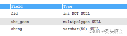
3、本文所用到的数据库表
china
4、WKT格式怎么转化为GeoJson格式
工具类
     /**
     *  WKT 格式转化为 GeoJson
     * @Param: 传入WKT形式的字符串
     */

    public static String WktToGeojson(String wktPoint){
        WKTReader reader = new WKTReader();
        Geometry geometry = null;
        try {
            geometry = reader.read(wktPoint);
        } catch (ParseException e) {
            e.printStackTrace();
        }
        StringWriter writer = new StringWriter();
        GeometryJSON g = new GeometryJSON();
        try {
            g.write(geometry, writer);
        } catch (IOException e) {
            e.printStackTrace();
        }
        String result = writer.toString();
        return result;
    }
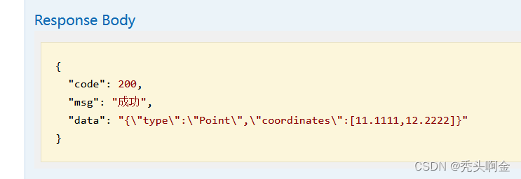
测试:
// wkt转geoJson
    @GetMapping("/WktToGeojson")
    public R WktToGeojson(){
        try {
            String wktPoint = "POINT(11.11111 12.22222)";
            String result = GeoToolsUtils.WktToGeojson(wktPoint);
            return R.ok().data(result);
        } catch (Exception e) {
            System.out.println("转换异常!" + e.toString());
        }
        return R.error();
    }
结果:
5、GeoJson格式怎么转化为WKT格式
工具类
/**
     *  GeoJson 格式转化为 WKT
     * @Param: 传入GeoJson形式的字符串
     */
    public static String GeojsonToWkt(String geoJson) {
        GeometryJSON gjson = new GeometryJSON();
        Reader reader = new StringReader(geoJson);
        Geometry geometry = null;
        try {
            geometry = gjson.read(reader);
        } catch (IOException e) {
            e.printStackTrace();
        }
        String wkt = geometry.toText();
        return wkt;
    }
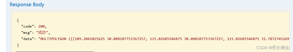
测试:
// geoJson转wkt
    @GetMapping("/GeojsonToWkt")
    public R GeojsonToWkt(){
        String geoJson="{\n" +
                "  \"type\": \"MultiPolygon\",\n" +
                "  \"coordinates\":\n" +
                "    [ \n" +
                "        [\n" +
                "            [\n" +
                "                [109.2041015625,30.088107753367257],\n" +
                "                [115.02685546875,30.088107753367257],\n" +
                "                [115.02685546875,32.7872745269555],\n" +
                "                [109.2041015625,32.7872745269555],\n" +
                "                [109.2041015625,30.088107753367257]\n" +
                "          \n" +
                "          \n" +
                "            ]\n" +
                "        ],\n" +
                "        [\n" +
                "            [\n" +
                "                [112.9833984375,26.82407078047018],\n" +
                "                [116.69677734375,26.82407078047018],\n" +
                "                [116.69677734375,29.036960648558267],\n" +
                "                [112.9833984375,29.036960648558267],\n" +
                "                [112.9833984375,26.82407078047018]\n" +
                "            ]\n" +
                "        ]\n" +
                "    ]\n" +
                "}";
        String wkt = GeoToolsUtils.GeojsonToWkt(geoJson);
        return R.ok().data(wkt);
    }
结果:
6、怎么把一张表的数据写入shp文件中
工具类
    /**
     * 写shp文件
     * @Param: 文件存放的路径和名字  格式:D:\\test\\locations.shp
     * @Param: 需要构建的shp文件的属性表字段名,其中第一个参数为空间数据名,比如 list["the_geom","fid","name","number"]
     * @Param: 需要存入属性表中的值,其中空间属性值为WKT格式,属性顺序与名称必须与第二个参数传入的顺序一致
     * @Param: 传入的空间属性类型,比如:Point、LineString、Polygon等
     */
    public static void WriteSHP(String path,List<String> list,List<?> dataList,Class<?> geometry) throws IOException, IllegalAccessException, ParseException {
        //1.创建shape文件对象
        File file =new File(path);

        Map<String, Serializable> params = new HashMap<>();

        //用于捕获参数需求的数据类
        //URLP:url to the .shp file.
        params.put(ShapefileDataStoreFactory.URLP.key, file.toURI().toURL());

        //2.创建一个新的数据存储——对于一个还不存在的文件。
        ShapefileDataStore ds = (ShapefileDataStore) new ShapefileDataStoreFactory().createNewDataStore(params);

        //3.定义图形信息和属性信息
        //SimpleFeatureTypeBuilder 构造简单特性类型的构造器
        SimpleFeatureTypeBuilder tBuilder = new SimpleFeatureTypeBuilder();

        //设置
        //WGS84:一个二维地理坐标参考系统,使用WGS84数据
        tBuilder.setCRS(DefaultGeographicCRS.WGS84);
        tBuilder.setName("shapefile");


        //构造属性表字段名
        tBuilder.add(list.get(0), geometry);
        for(int i=1;i<list.size();i++){
            tBuilder.add(list.get(i),String.class);
        }


        //设置此数据存储的特征类型
        ds.createSchema(tBuilder.buildFeatureType());

        //设置编码
        ds.setCharset(Charset.forName("GBK"));

        //设置writer
        //为给定的类型名称创建一个特性写入器

        //1.typeName:特征类型
        //2.transaction :事物,写入失败,回滚
        //3.ShapefileDataStore::getTypeNames:
		/*public String[] getTypeNames()
		 获取这个数据存储保存的类型名称数组。
		ShapefileDataStore总是返回一个名称
		*/
        FeatureWriter<SimpleFeatureType, SimpleFeature> writer = ds.getFeatureWriter(
                ds.getTypeNames()[0], Transaction.AUTO_COMMIT);


        //从数据库中读取数据
        SimpleFeature feature = null;

        GeometryFactory geometryFactory = new GeometryFactory();


        for(Object o:dataList){
            feature= writer.next();


            // 通过反射机制获取对象的属性值
            Class<?> aClass = o.getClass();
            Field[] fields = aClass.getDeclaredFields();

            for(Field f:fields){
                f.setAccessible(true);

                // 获得属性值
                String s=f.get(o).toString();


                if(s.indexOf("POINT")==0||s.indexOf("MULTIPOINT")==0||s.indexOf("LINESTRING")==0
                    ||s.indexOf("MULTILINESTRING")==0||s.indexOf("POLYGON")==0||s.indexOf("MULTIPOLYGON")==0){

                    WKTReader reader = new WKTReader(geometryFactory);
                    feature.setAttribute(list.get(0),reader.read(s));

                }else{
                    // 设置属性名和属性值
                    feature.setAttribute(f.getName(), s);
                }
            }
        }

        //写入
        writer.write();

        //关闭
        writer.close();

        //释放资源
        ds.dispose();
    }
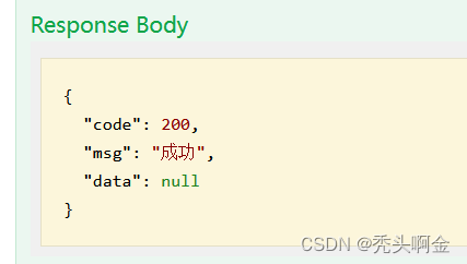
测试:
Controller
// 写shp文件
@PostMapping("/WriteSHP")
public R WriteSHP() throws IOException, ParseException, IllegalAccessException {
String path="D:\\test\\china\\china.shp";
ArrayList<String> arr = new ArrayList<>();
arr.add("the_geom");
arr.add("fid");
arr.add("sheng");
GeoToolsUtils.WriteSHP(path,arr, chinaService.getAll(), MultiPolygon.class);
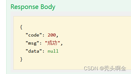
return R.ok();
}
service:
List<China> getAll();
serviceImpl:
    @Autowired
    private ChinaMapper chinaMapper;

    @Override
    public List<China> getAll() {
        return chinaMapper.getAll();
    }
mapper:
int insert(China china);
mapper.xml:
    <resultMap id="BaseChina" type="China">
        <id column="fid" jdbcType="INTEGER" property="fid"/>
        <result column="the_geom" jdbcType="OTHER" property="theGeom" />
        <result column="sheng" jdbcType="OTHER" property="sheng" />
    </resultMap>

    <select id="getAll" resultMap="BaseChina">
        select fid,ST_ASWKT(the_geom) AS the_geom,sheng from china
    </select>
结果:
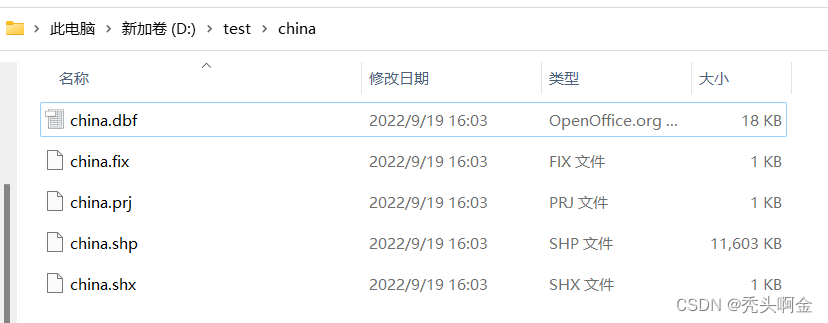
查看 D:\test\china 路径:
使用ArcMap查看china.shp:

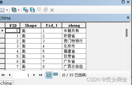
查看china.shp的属性表:
7、怎么读取shp文件并把数据存入数据库表中
工具类
/**
     *     读shp文件并把数据存入数据库
     * @Param: 需要读取的shp文件的路径及名字
     * @return
     */
    public static FeatureCollection<SimpleFeatureType, SimpleFeature> ReadSHP(String path) throws Exception{

        //构建shapefile数据存储的实例
        ShapefileDataStoreFactory dataStoreFactory = new ShapefileDataStoreFactory();

        //基于路径构建文件对象
        File file = new File(path);

        //构建一个已存在的shapfile数据源
        //ShapefileDataStore:数据存储实现,允许从Shapefiles读取和写入
        ShapefileDataStore ds = (ShapefileDataStore) dataStoreFactory.createDataStore(file.toURI().toURL());

        //设置编码,防止中文读取乱码
        ds.setCharset(Charset.forName("GBK"));

        //getFeatureSource():ContentFeatureSource
        //这个特性是由 FeatureCollection提供的操作完成的。单独的特征记忆实现由子类提供:
        //SimpleFeatureSource特征资源明确地使用FeatureCollection【集合】,可迭代
        SimpleFeatureSource featureSource = ds.getFeatureSource();

        //getFeatures():以FeatureCollection的形式检索所有特性。
        //一个用于处理FeatureCollection的实用工具类。提供一个获取FeatureCollection实例的机制
        FeatureCollection<SimpleFeatureType, SimpleFeature> result=featureSource.getFeatures();

        System.out.println("几何对象总共有:"+result.size());

        return result;
    }
测试: 这里的shp文件基于上面第6点所构造的shp文件,while循环中设置China属性值的顺序是按照shp文件属性表中的顺序来的
controller
// 读取shp文件并把数据存入mysql
    @PostMapping("/ReadSHP")
    public R ReadSHP() throws Exception {
        //基于shapfile文件,进行读取
        String path = "D:\\test\\china\\china.shp";

        FeatureCollection<SimpleFeatureType, SimpleFeature> result = GeoToolsUtils.ReadSHP(path);

        System.out.println("几何对象总共有:"+result.size());
        //features():返回一个FeatureIterator迭代器
        SimpleFeatureIterator it =(SimpleFeatureIterator) result.features();

        while(it.hasNext()){
            SimpleFeature feature = it.next();
            //迭代属性【属性我们可以理解为一个几何对象的属性节点,也就是对一个几何图形的描述字段】
            Iterator<Property> ip = feature.getProperties().iterator();
            System.out.println("========================");

            China china = new China();

            Property property = ip.next();
            china.setTheGeom(String.valueOf(property.getValue()));

            property=ip.next();
            china.setFid(Integer.parseInt((String) property.getValue()));

            property=ip.next();
            china.setSheng(String.valueOf(property.getValue()));


            chinaService.insertWKT(china);
        }
        it.close();


        return R.ok();
    }
service:
int insertWKT(China china);
serviceImpl:
    @Override
    public int insertWKT(China china) {
        return chinaMapper.insertWKT(china);
    }
mapper:
int insertWKT(China china);
mapper.xml: 我这里数据库中空间字段the_geom的类型设置为longtext,是以WKT格式直接存入数据库
    <insert id="insertWKT" parameterType="China">
        insert into newchina  (the_geom,sheng) values (#{theGeom},#{sheng})
    </insert>
结果:
数据库中也有值:
8、一些常用的空间函数(mysql版)
ST_AsText(), ST_AsWKT()                        从Geometry格式转换为WKT
ST_AsGeoJSON()                                  从Geometry格式转换为GeoJson
ST_GeomFromText(), ST_GeometryFromText()       从WKT格式返回Geometry
等等


 489
489


 被折叠的 条评论
为什么被折叠?
被折叠的 条评论
为什么被折叠?
 到【灌水乐园】发言


