


 超级会员免费看
前言
路径规划是机器人导航和自主移动中的一个关键问题。其中,A算法是一种广泛应用的最短路径搜索算法,因其高效和最优性而备受关注。本文将介绍如何在MATLAB环境下实现A算法,并在2D网格地图上进行路径规划。该实现为机器人导航、无人车路径规划等应用提供了一个有价值的参考。
正文
A*算法是一种启发式搜索算法,通过评估每个节点到终点的估计代价来确定最优路径。其核心思想如下:
- 维护两个列表:开放列表(Open List)和关闭列表(Closed List)。开放列表存储待搜索的节点,关闭列表存储已经搜索过的节点。
- 从开放列表中选择一个代价最小的节点,将其从开放列表移动到关闭列表。
- 对于选中节点的邻居节点,计算它们到起点的实际代价(g值)和到终点的估计代价(h值)。
- 如果邻居节点不在开放列表或关闭列表中,或者它们的代价更小,则将其加入开放列表,并更新其父节点。
- 重复步骤2-4,直到找到终点或开放列表为空(无解)。
- 从终点回溯到起点,得到最短路径。
在2D网格地图上实现A*算法时,可以使用曼哈顿距离作为启发式函数(h值)。曼哈顿距离是两个点在水平和垂直方向上的绝对距离之和,它是从当前节点到终点的最小距离的下界。
代码实现
以下是MATLAB实现A*算法的代码:
% 创建2D网格地图
map = [
    0 0 0 0 0 0 0 0 0 0;
    0 0 1 1 0 0 0 1 0 0;
    0 0 0 1 0 0 0 1 0 0;
    0 0 0 1 0 0 1 1 0 0;
    0 0 0 1 0 0 1 0 0 0;
    0 0 0 1 1 1 1 0 0 0;
    0 0 0 0 0 0 0 0 0 0;
    0 0 0 1 1 1 1 1 0 0;
    0 0 0 0 0 0 0 1 0 0;
    0 0 0 0 0 0 0 0 0 0;
];

% 设置起点和终点
start = [2, 2];
goal = [9, 9];

% 运行A*算法
path = a_star_path_planning(map, start, goal);

% 可视化结果
visualize_path(map, start, goal, path);

function path = a_star_path_planning(map, start, goal)
    [rows, cols] = size(map);
    open_list = [start, 0, heuristic(start, goal)];
    closed_list = false(rows, cols);
    parent = zeros(rows, cols, 2);
    g_score = inf(rows, cols);
    g_score(start(1), start(2)) = 0;

    while ~isempty(open_list)
        [~, idx] = min(open_list(:, 3));
        current = open_list(idx, 1:2);

        if isequal(current, goal)
            path = reconstruct_path(parent, start, goal);
            return;
        end

        open_list(idx, :) = [];
        closed_list(current(1), current(2)) = true;

        neighbors = get_neighbors(current, rows, cols);
        for i = 1:size(neighbors, 1)
            neighbor = neighbors(i, :);
            if closed_list(neighbor(1), neighbor(2)) || map(neighbor(1), neighbor(2)) == 1
                continue;
            end

            tentative_g = g_score(current(1), current(2)) + 1;

            if tentative_g < g_score(neighbor(1), neighbor(2))
                parent(neighbor(1), neighbor(2), :) = current;
                g_score(neighbor(1), neighbor(2)) = tentative_g;
                f_score = tentative_g + heuristic(neighbor, goal);

                if ~any(ismember(open_list(:, 1:2), neighbor, 'rows'))
                    open_list = [open_list; neighbor, f_score];
                else
                    open_list(ismember(open_list(:, 1:2), neighbor, 'rows'), 3) = f_score;
                end
            end
        end
    end
    path = [];
end

function h = heuristic(node, goal)
    h = norm(node - goal, 1);  % Manhattan distance
end

function neighbors = get_neighbors(node, rows, cols)
    directions = [-1 0; 1 0; 0 -1; 0 1];
    neighbors = node + directions;
    neighbors = neighbors(neighbors(:, 1) > 0 & neighbors(:, 1) <= rows & ...
                          neighbors(:, 2) > 0 & neighbors(:, 2) <= cols, :);
end

function path = reconstruct_path(parent, start, goal)
    path = goal;
    current = goal;
    while ~isequal(current, start)
        current = squeeze(parent(current(1), current(2), :))';
        path = [current; path];
    end
end

function visualize_path(map, start, goal, path)
    figure;
    imagesc(map);
    colormap('gray');
    hold on;
    plot(start(2), start(1), 'go', 'MarkerSize', 10, 'LineWidth', 2);
    plot(goal(2), goal(1), 'ro', 'MarkerSize', 10, 'LineWidth', 2);
    if ~isempty(path)
        plot(path(:, 2), path(:, 1), 'b-', 'LineWidth', 2);
    end
    title('A* 算法路径规划');
    xlabel('X');
    ylabel('Y');
    axis equal;
    grid on;
end
结果与说明
结果图
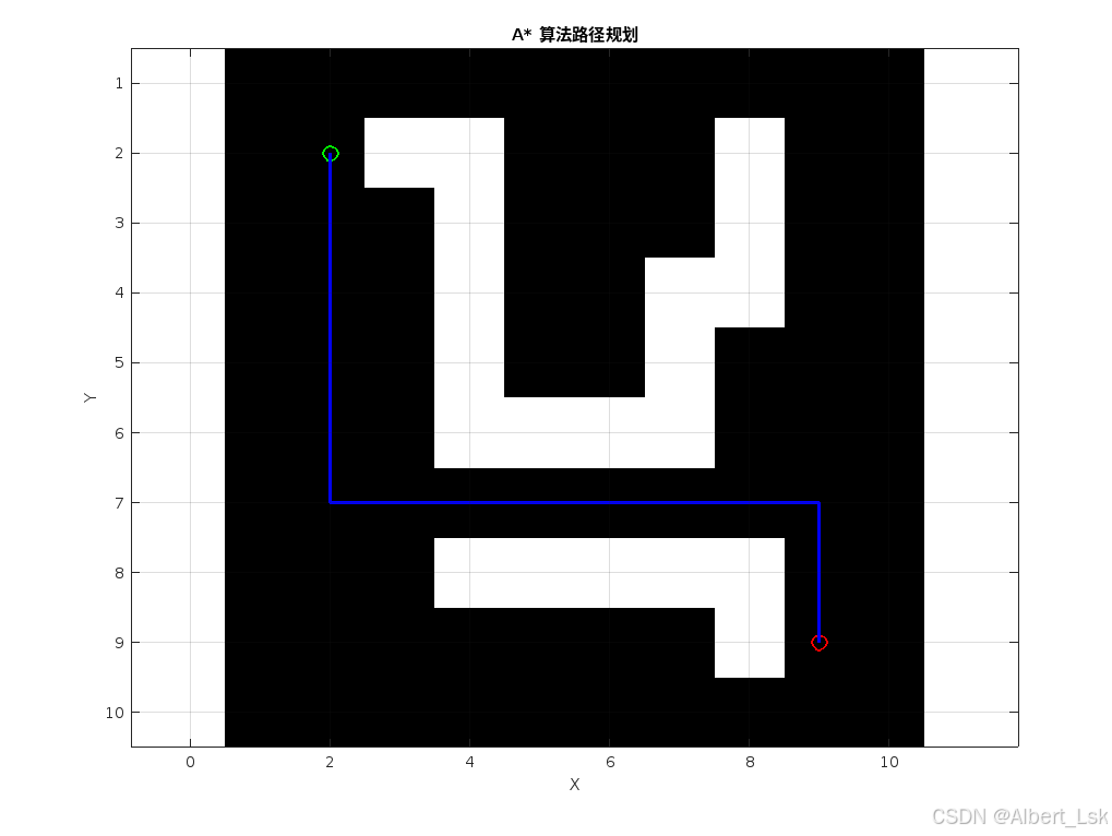
结果说明
上图展示了A*算法在给定2D网格地图上的路径规划结果。图中,白色区域表示可通行区域,黑色区域表示障碍物。绿色圆点表示起点,红色圆点表示终点,蓝色线条表示算法找到的最短路径。
从结果可以看出,A*算法成功避开了障碍物,找到了一条从起点到终点的最短路径。该路径绕过了中间的障碍区域,同时保持了路径的平滑性和效率。
总结
本文介绍了如何使用MATLAB实现基于A算法的路径规划。A算法是一种启发式搜索算法,通过评估每个节点到终点的估计代价来确定最优路径。在2D网格地图上,我们可以使用曼哈顿距离作为启发式函数,并通过维护开放列表和关闭列表来高效地搜索最短路径。
该实现展示了A*算法在MATLAB环境下的应用,为机器人导航、无人车路径规划等领域提供了一个有价值的参考。未来的工作可以进一步扩展该算法,如支持更复杂的地图环境、考虑动态障碍物、结合其他优化技术等,以满足更广泛的应用需求。


 被折叠的 条评论
为什么被折叠?
被折叠的 条评论
为什么被折叠?
 到【灌水乐园】发言


