


记录在学习过程中遇到的水文数据产品,会不断更新补充~~
1.Database for Hydrological Time Series of Inland Waters (DAHITI)
内陆水域水文时间序列数据库(DAHITI)由Deutsches Geodätisches Forschungsinstitut der Technischen Universität München (DGFI-TUM)于2013年开发,提供内陆水域的水位时间序列。
数据集产品主要包括:Water Level Time Series from Satellite Altimetry、Surface Area Time Series from Optical Imagery、Time Series of Volume Variations、Hypsometry等。
测高卫星发展情况:
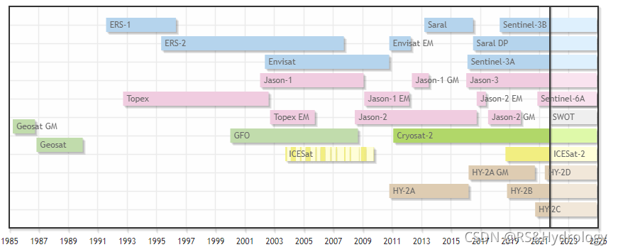
图片来自https://dahiti.dgfi.tum.de/en/products/water-level-altimetry/
遥感影像监测湖面发展情况:
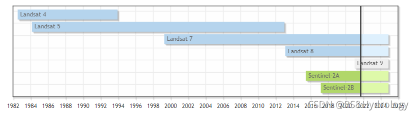
图片来源:https://dahiti.dgfi.tum.de/en/products/surface-area/
官网:https://dahiti.dgfi.tum.de/en/
2.The SRTM Water Body Data (SWBD): SRTM水体数据(SWBD)
SWBD数据集是由美国国家地理空间情报局(NGA)创建的,用于提供全球高分辨率(90米)的海洋、湖泊和河流岸线的数据。
下载链接:https://dds.cr.usgs.gov/srtm/version2_1/SWBD/
3.HydroSHEDS :Hydrological data and maps based on SHuttle Elevation Derivatives at multiple Scales
HydroSHEDS提供一套水流数据集,常用于描述河流流域。
下载链接:http://hydrosheds.cr.usgs.gov/
4.GRACES数据:可以用于监测陆地水储量(TWS)变化的数据。
数据下载链接:https://podaac.jpl.nasa.gov/GRACE
5.GPCP:Global Precipitation Climatology Project
提供1979年至今的月降水资料将观测资料和卫星降水资料,并合并成2.5°× 2.5°(~250 × 250 km)的全球网格数据。
6.Thematic Exploitation Platform (TEP) for Hydrology (https://hydrology-tep.eu/).获取卫星测高数据
7、实测数据下载:
(1)湖北省水情报表:http://113.57.190.228:8001/#!/web/Report/RiverReport
数据处理方法:https://blog.csdn.net/weixin_45058703/article/details/126581471
(2)印度实测水位数据:https://indiawris.gov.in/wris/#/
(3)亚马逊河流水位数据:https://www.gov.br/ana/pt-br/assuntos/monitoramento-e-eventos-criticos/monitoramento-hidrologico
(4)中国水雨信息:http://xxfb.mwr.cn/sq_djdh.html
爬虫下载:https://blog.csdn.net/qq_37948866/article/details/119757528
(5)下载黄河水情日报,实现多日连续爬取,自动保存为excel表格
数据网站:http://61.163.88.227:8006/hwsq.aspx?sr=0nkRxv6s9CTRMlwRgmfFF6jTpJPtAv87
数据爬虫:https://github.com/944568752/Daily-Yellow-River-Information-Download
(6)Polish rivers水位实测数据:National Research Institute(Instytut Meteorologii i Gospodarki Wodnej – Pa´nstwowy InstytutBadawczy, IMGW-PIB)
来源:The accuracy of the Sentinel-3A altimetry over Polish rivers


 4260
4260

 被折叠的 条评论
为什么被折叠?
被折叠的 条评论
为什么被折叠?
 到【灌水乐园】发言


