


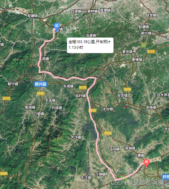
效果:
上代码:
<template>
<section>
    <div id="leafletMap" class="home" :style="{height: '92vh',width: '100vw' ,background:'#000'}"></div>
</section>
</template>

<script>
import L from 'leaflet'
require('../../../util/leaflet.contextmenu.js')
require('../../../util/leaflet-ant-path.js')

import startIcon from '@assets/img/start.png'
import guoIcon from '@assets/img/guo.png'
import stopIcon from '@assets/img/stop.png'


methods:{

      initMap() {

           let map = L.map('leafletMap', {
                minZoom: 6,
                maxZoom: 14,
                center: [22.50, 113.31], //广东的中心
                zoom:10,
                zoomControl: false,
                attributionControl: false,
                crs: L.CRS.Baidu,
                contextmenu: true,
                contextmenuWidth: 140,
                contextmenuItems: [{
                        text: '设置为起点',
                        callback: that.setStartPoint,
                    },
                    {
                        text: '设置为中间点',
                        callback: this.setWaypoints,
                    },
                    {
                        text: '设置为终点',
                        callback: that.setStopPoint,
                    },
                    '-',
                    {
                        text: '开始规划',
                        callback: that.calcRoute,
                    },
                ],
            })
        },
        setStartPoint(e) {
            this.startPoint = [e.latlng.lat, e.latlng.lng]
            L.marker([e.latlng.lat, e.latlng.lng], {
                icon: L.icon({
                    iconUrl: startIcon,
                    iconSize: L.point(20, 30),
                }),
            }).addTo(this.map)
        },
        setWaypoints(e) {
            this.wayPoint = [e.latlng.lat, e.latlng.lng]
            L.marker([e.latlng.lat, e.latlng.lng], {
                icon: L.icon({
                    iconUrl: guoIcon,
                    iconSize: L.point(20, 30),
                }),
            }).addTo(this.map)
        },
        setStopPoint(e) {
            this.endPoint = [e.latlng.lat, e.latlng.lng]
            L.marker([e.latlng.lat, e.latlng.lng], {
                icon: L.icon({
                    iconUrl: stopIcon,
                    iconSize: L.point(20, 30),
                }),
            }).addTo(this.map)
        },
        calcRoute() {
            let that=this
            let url = '/common/route'
            let grahhVo = {
                fromLat: this.startPoint[0],
                fromLng: this.startPoint[1],
                toLat: this.endPoint[0],
                toLng: this.endPoint[1],
                vehicle: '',
            }
            postAction(url, grahhVo).then(res => {
                console.log(res)
                that.success(res)
            })

        },
        success(res) {
             var coords=res.result.point
            // var coords = [
            //     [25.376636777267127, 114.91269229996807],
            //     [25.066564774717097,113.7775998641828],
            //     [24.066564774717097,115.7775998641828]
            // ]
            var path = L.polyline.antPath(coords, {
                "paused": true, //暂停  初始化状态
                "reverse": false, //方向反转
                "delay": 2000, //延迟,数值越大效果越缓慢
                "dashArray": [10, 20], //间隔样式
                "weight": 5, //线宽
                "opacity": 0.9, //透明度
                "color": "pink", //颜色
                "pulseColor": "pink" //块颜色
            });
              path.addTo(this.map);
                var mark=[res.result.point[0]]
                let distance = (res.result.distance/1000).toFixed(2)
                 let time = (res.result.time/1000/3600).toFixed(2)
                for (var a = L.featureGroup().addTo(this.map), t = 0; t < mark.length; t++) {
                    var n = mark[t];
                    var divIcon;
                    divIcon = L.divIcon({
                        iconSize: [0, 0],
                        popupAnchor: [0, 0],
                        html: '<div style="width:150px;height:50px;background:#fff;border-radius:5px;padding:5px;color:#000;margin-left:30px;margin-top:30px;" id="wayTip">全程'+distance+'公里,开车预计'+time+'小时</div>'
                    });
                    var o = L.marker(n, {
                        icon: divIcon
                    });
                    a.addLayer(o);
                }

        },


}


 2509
2509


 被折叠的 条评论
为什么被折叠?
被折叠的 条评论
为什么被折叠?
 到【灌水乐园】发言


