


目录
前言
高德地图官方API:https://lbs.amap.com/demo/javascript-api/example/overlayers/polygon-draw-and-edit
高德地图API版本:1.4.15
使用JS实现高德地图多边形围栏设置(除了简单的例子,还附带本人在项目中的实现)
效果
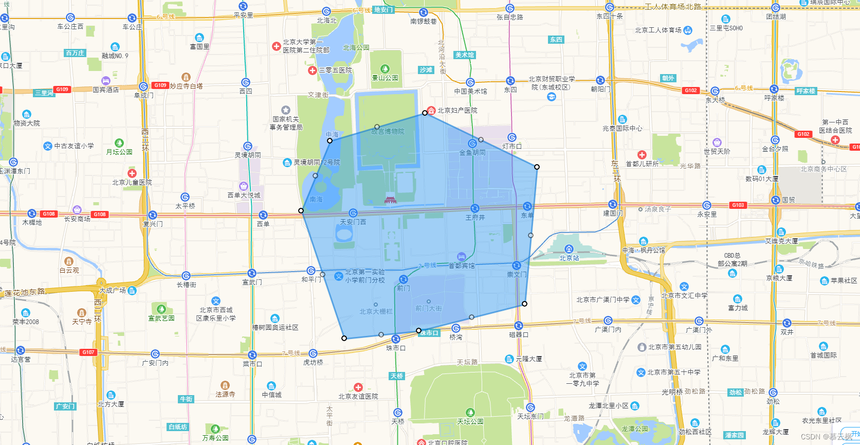
实现
引入js
需要添加安全密钥和key,之所以要使用安全密钥是官方在2021-12-02的时候改的,原本只需要key即可的
参考网址:https://lbs.amap.com/api/javascript-api/guide/abc/prepare
这里plugin=AMap.*****是自己需要到的对象
<script type="text/javascript">
        window._AMapSecurityConfig = {
            securityJsCode:'bf5ed*********************886', // 安全密钥(正式项目官方推荐使用nginx代理方式引入密钥)
        }
</script>
<script type="text/javascript" src="https://webapi.amap.com/maps?v=1.4.15&key=22d1******************b8&plugin=AMap.Autocomplete,AMap.PlaceSearch,AMap.PolyEditor,AMap.Marker"></script>
html实现
<!doctype html>
<html>

	<head>
		<meta charset="utf-8">
		<meta http-equiv="X-UA-Compatible" content="IE=edge">
		<meta name="viewport" content="initial-scale=1.0, user-scalable=no, width=device-width">
		<style>
			html,
			body,
			#container {
				width: 100%;
				height: 100%;
			}
		</style>
		<title>多边形的绘制和编辑</title>
		<link rel="stylesheet" href="https://a.amap.com/jsapi_demos/static/demo-center/css/demo-center.css" />
		<script type="text/javascript">
		        window._AMapSecurityConfig = {
		            securityJsCode:'bf5******************886',
		        }
		</script>
		<script src="https://webapi.amap.com/maps?v=1.4.15&key=22d******************a20b8&plugin=AMap.PolyEditor"></script>
	</head>

	<body>
		<div id="container"></div>
		<div class="input-card" style="width: 120px">
			<button class="btn" onclick="startEdit()" style="margin-bottom: 5px">开始编辑</button>
			<button class="btn" onclick="submitMap()">结束编辑</button>
		</div>
		<script type="text/javascript">

			var temp_lnglat = []; // 临时存储位置
			var tempMap = {}; // 临时存储地图对象

			// 要绘画位置的经纬度
			var lngLat = [116.400274, 39.905812];

			initMap(lngLat);

			/**
			 * ---------------------------------------------------------------------------------------------------------------
			 * 初始化地图
			 */
			function initMap(lngLat){
				tempMap.map = new AMap.Map("container", {
					center: lngLat,
					zoom: 14
				});

				createPolygon(lngLat);
			}

			/**
			 * ---------------------------------------------------------------------------------------------------------------
			 * 创建多边形
			 * @param {Object} paths
			 */
			function createPolygon(lngLat, paths){
				// 绘画多边形的各个角的经纬度(如果没有就使用这个,在当前位置上创建默认的多边形)
				if(!paths || paths.length < 1){
					paths = [
						[lngLat[0] + 0.003048, lngLat[1] + 0.014442],
						[lngLat[0] + 0.010429, lngLat[1] - 0.008257],
						[lngLat[0] + 0.002018, lngLat[1] -  0.013458],
						[lngLat[0] - 0.010427, lngLat[1] - 0.014446]
					]
				}
				// 赋值给临时数组(提交的时候要这些多边形角的经纬度)
				temp_lnglat = paths;
				// 创建绘画
				var polygon = new AMap.Polygon({
					path: paths,
					strokeColor: "#0f79d7",
					strokeWeight: 3,
					strokeOpacity: 0.6,
					fillOpacity: 0.4,
					fillColor: '#1791fc',
					zIndex: 50,
				})
				tempMap.map.add(polygon)
				// 缩放地图到合适的视野级别
				tempMap.map.setFitView([polygon])
				// 编辑绘画对象
				tempMap.polyEditor = new AMap.PolyEditor(tempMap.map, polygon)
				// 事件
				tempMap.polyEditor.on('addnode', function(event) {
					console.log('触发事件:addnode ------------------------------------------')
					console.log("添加:", event)
					console.log("添加-经度:", event.lnglat.lng, "纬度:", event.lnglat.lat)
				})
				tempMap.polyEditor.on('adjust', function(event) {
					console.log('触发事件:adjust ------------------------------------------')
					console.log("修改:", event)
					console.log("修改-经度:", event.lnglat.lng, "纬度:", event.lnglat.lat)
				})
				tempMap.polyEditor.on('removenode', function(event) {
					console.log('触发事件:removenode ------------------------------------------')
					console.log("removenode:", event)
				})
				tempMap.polyEditor.on('end', function(event) {
					console.log('触发事件: end ------------------------------------------')
					console.log("end:", event)
					// event.target 即为编辑后的多边形对象
				})
			}

			/**
			 * ---------------------------------------------------------------------------------------------------------
			 * 清除绘画
			 */
			function clearMap() {
			    tempMap.map.clearMap(tempMap.polyEditor)
			    tempMap.map.remove(tempMap.polyEditor)
			}

			/**
			 * ---------------------------------------------------------------------------------------------------------------
			 * 开始编辑
			 */
			function startEdit(){
				// 打开编辑
				tempMap.polyEditor.open();
			}

			/**
			 * ---------------------------------------------------------------------------------------------------------------
			 * 提交经纬度
			 */
			function submitMap() {
				// 关闭绘画
				//tempMap.polyEditor.close();
				// 获取所有的经纬度
				if(tempMap.polyEditor.bu){
					temp_lnglat = tempMap.polyEditor.bu[0];
				}
				// 去除Q和R属性值,保留lng和lat的值
				temp_lnglat = temp_lnglat.map(function(item, index){
					return [item.lng, item.lat];
				})
				console.log("获取所有坐标:", JSON.stringify(temp_lnglat));
			}

		</script>
	</body>

</html>
html搜索提示
<!doctype html>
<html>
<head>
    <meta charset="utf-8">
    <meta http-equiv="X-UA-Compatible" content="IE=edge">
    <meta name="viewport" content="initial-scale=1.0, user-scalable=no, width=device-width">
    <title>输入提示</title>
    <link rel="stylesheet" href="https://a.amap.com/jsapi_demos/static/demo-center/css/demo-center.css" />
    <style>
        html,
        body,
        #container {
          width: 100%;
          height: 100%;
        }
    </style>
</head>
<body>
<div id="container"></div>
<div class="info">
    <div class="input-item">
      <div class="input-item-prepend">
        <span class="input-item-text" style="width:8rem;">请输入关键字</span>
      </div>
      <input id='tipinput' type="text">
    </div>
</div>

<script type="text/javascript">
        window._AMapSecurityConfig = {
            securityJsCode:'bf5********************886',
        }
</script>
<script type="text/javascript" src="https://webapi.amap.com/maps?v=1.4.15&key=22d********************0b8&plugin=AMap.Autocomplete,AMap.PlaceSearch"></script>
<script type="text/javascript">
    /**
	 * ---------------------------------------------------------------------------------------------------------
	 * 渲染地图
	 */
	function initMap(){
		var map = new AMap.Map('container', {
			resizeEnable: true, //是否监控地图容器尺寸变化
		});
		// 输入提示
	    var autoOptions = {
	        input: "tipinput"
	    };
	    var auto = new AMap.Autocomplete(autoOptions);
	    // 构造地点查询类
	    var placeSearch = new AMap.PlaceSearch({
	        map: map
	    });
	    // 注册监听,当选中某条记录时会触发
	    AMap.event.addListener(auto, "select", selectSearch);
	    function selectSearch(e) {
	    	console.log(e)
	        placeSearch.setCity(e.poi.adcode);
	        placeSearch.search(e.poi.name);  // 关键字查询查询
	    }
	}
	initMap();
</script>
</body>
</html>
在项目中使用
效果图
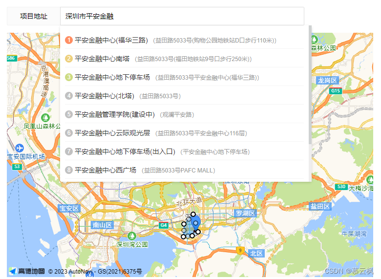
这是本人在项目中的使用(复制粘贴可用)
引入
记得把安全密钥和key改了
<script type="text/javascript">
	window._AMapSecurityConfig = {
		securityJsCode:'bf5e**********************886',
	}
</script>
<script src="https://webapi.amap.com/maps?v=1.4.15&key=22d**********************20b8&plugin=AMap.Autocomplete,AMap.PlaceSearch,AMap.PolyEditor,AMap.Marker"></script>
html
这里使用layui框架的,所有直接复制过来了,只取关键即可
<div class="layui-form-item">
	<label class="layui-form-label">项目地址</label>
	<div class="layui-input-block" style="width: 500px;">
		<input type="text" name="addr" id="addr" placeholder="输入地址后选择详细,再操作地图"autocomplete="off" class="layui-input">
		<div class="lay-search-content">
			<ul></ul>
		</div>
	</div>
</div>
<div class="layui-form-item">
	<!-- map地图 -->
	<div class="container" id="container" style="height: 500px;width: 750px;"></div>
</div>
CSS
自己写的效果
.lay-search-content{
	padding: 10px;
	background: white;
	border-radius: 4px;
	color: #333333;
	line-height: 15px;
	box-shadow: #00000024 0px 2px 5px 0;
	max-height: 300px;
	overflow: auto;
	display: none;
	position: absolute;z-index: 99999;
	width: 99%;
}
.lay-search-content li{
	list-style: none;
	margin: 5px 0px;
	padding: 8px 0px;
	border-bottom: 1px solid whitesmoke;
	cursor: pointer;
}
.lay-search-content li:hover{
	background: #f1f1f1;
}
.lay-search-mark{
	width: 16px;
	display: inline-block;
	height: 16px;
	background: #c1c1c1;
	text-align: center;
	line-height: 16px;
	border-radius: 50%;
	margin-right: 4px;
	color: white;
	font-size: 12px;
	position: relative;
	top: -1px;
}
具体实现JS
var temp_lnglat = [116.400274, 39.905812]; // 临时存储当前位置
var temp_fence_lnglat = []; // 临时存储所有位置
var tempMap = {}; // 临时存储地图对象

/**
 * ---------------------------------------------------------------------------------------------------------
 * 重置地图值
 */
function clearMap(state) {
    if(!state){ // 修改的话不赋值
        temp_lnglat = [116.400274, 39.905812];
        temp_fence_lnglat = [];
    }
    if(tempMap.polyEditor){
        tempMap.map.clearMap(tempMap.polyEditor)
        tempMap.map.remove(tempMap.polyEditor)
    }
}

/**
 * ---------------------------------------------------------------------------------------------------------
 * 渲染地图
 */
function initMap(state){
    tempMap.map = new AMap.Map('container', {
		resizeEnable: true, //是否监控地图容器尺寸变化
        center: temp_lnglat,
        zoom: 14,
	});
    // 构造地点查询类
    tempMap.placeSearch = new AMap.PlaceSearch({
        city: "全国", // 兴趣点城市
    });
    $("#addr").bind('input propertychange', function() {
        var text = $("#addr").val();
        searchAddr(text)
    })
    clickPosition(temp_lnglat[0], temp_lnglat[1], state);
}

/**
 * --------------------------------------------------------------------------------------------------------------------
 * 地图搜索
 * @return
 */
function searchAddr(text) {
    // 关键字查询,设置成输入框input就好了,下面返回的集合中有name,可以自己重新查询结果选择
    tempMap.placeSearch.search(text, function (status, result) {
        // 查询成功时,result即对应匹配的POI信息
        console.log("搜索结果坐标:", result)
        if (!result.poiList){
            return;
        }
        var pois = result.poiList.pois;
        $(".lay-search-content").css("display", "block");
        $(".lay-search-content>ul").empty();
        for (var i = 0; i < pois.length; i++) {
            var poi = pois[i];
            var s = '<li οnclick="clickPosition(' + poi.location.lng + ', ' + poi.location.lat + ')">';
            var index = i + 1;
            if (index == 1) {
                s += '   <span class="lay-search-mark" style="background: #ff8e63;">' + index + '</span>' + poi.name;
            } else if (index == 2) {
                s += '   <span class="lay-search-mark" style="background: #edd07d;">' + index + '</span>' + poi.name;
            } else if (index == 3) {
                s += '   <span class="lay-search-mark" style="background: #cddb82;">' + index + '</span>' + poi.name;
            } else {
                s += '   <span class="lay-search-mark">' + index + '</span>' + poi.name;
            }
            s += '   <span style="color: #999;font-size: 12px">(' + poi.address + ')</span>';
            s += '</li>';
            $(".lay-search-content>ul").append(s);
            var marker = [];
            marker[i] = new AMap.Marker({
                position: poi.location,   // 经纬度对象,也可以是经纬度构成的一维数组[116.39, 39.9]
                offset: new AMap.Pixel(0, -20),// 相对于基点的偏移位置
                title: poi.name
            });
            // [点标上面显示内容信息]
            var infoWindow = new AMap.InfoWindow({offset: new AMap.Pixel(0, -30)});// 地图位置对象
            // 点击弹出内容
            marker[i].content = poi.name;
            marker[i].on('click', markerClick);

            function markerClick(e) {
                var position = e.target.getPosition();
                var content = "<div>" + e.target.content + "</div>"; // 要显示的内容
                content += "<div style='text-align: center'><a class='layui-btn layui-btn-sm' οnclick='clickPosition(" + position.lng + ", " + position.lat + ")'>选择设置围栏</a></div>"
                infoWindow.setContent(content);
                infoWindow.open(tempMap.map, position);
            }
            // 将创建的点标记添加到已有的地图实例:
            tempMap.map.add(marker[i]);
        }
        tempMap.map.setFitView();
    })
}

/**
 * --------------------------------------------------------------------------------------------------------------------
 * 搜索结果选择设置围栏
 * @param lng
 * @param lat
 */
function clickPosition(lng, lat, state) {
    $(".lay-search-content").css("display", "none");
    clearMap(state);
    temp_lnglat = [lng, lat];
    // 添加点标
    var markers = new AMap.Marker({
        position: temp_lnglat,   // 经纬度对象,也可以是经纬度构成的一维数组[116.39, 39.9]
        offset: new AMap.Pixel(0, -20),// 相对于基点的偏移位置
    });
    tempMap.map.add(markers);
    tempMap.map.setCenter(temp_lnglat)
    createPolygon(temp_lnglat, temp_fence_lnglat);
}
/**
 * ---------------------------------------------------------------------------------------------------------------
 * 创建多边形
 * @param {Object} paths
 */
function createPolygon(lngLat, paths){
    // 绘画多边形的各个角的经纬度(如果没有就使用这个,在当前位置上创建默认的多边形)
    if(!paths || paths.length < 1){
        paths = [
            [lngLat[0] + 0.003048, lngLat[1] + 0.014442],
            [lngLat[0] + 0.010429, lngLat[1] - 0.008257],
            [lngLat[0] + 0.002018, lngLat[1] -  0.013458],
            [lngLat[0] - 0.010427, lngLat[1] - 0.014446]
        ]
    }
    // 赋值给临时数组(提交的时候要这些多边形角的经纬度)
    temp_fence_lnglat = paths;
    // 创建绘画
    var polygon = new AMap.Polygon({
        path: paths,
        strokeColor: "#0f79d7",
        strokeWeight: 3,
        strokeOpacity: 0.6,
        fillOpacity: 0.4,
        fillColor: '#1791fc',
        zIndex: 50,
    })
    tempMap.map.add(polygon)
    // 缩放地图到合适的视野级别
    tempMap.map.setFitView([polygon])
    // 编辑绘画对象
    tempMap.polyEditor = new AMap.PolyEditor(tempMap.map, polygon)
    // 事件
    tempMap.polyEditor.on('addnode', function(event) {
        console.log('触发事件:addnode ------------------------------------------')
        console.log("添加:", event)
        console.log("添加-经度:", event.lnglat.lng, "纬度:", event.lnglat.lat)
    })
    tempMap.polyEditor.on('adjust', function(event) {
        console.log('触发事件:adjust ------------------------------------------')
        console.log("修改:", event)
        console.log("修改-经度:", event.lnglat.lng, "纬度:", event.lnglat.lat)
    })
    tempMap.polyEditor.on('removenode', function(event) {
        console.log('触发事件:removenode ------------------------------------------')
        console.log("removenode:", event)
    })
    tempMap.polyEditor.on('end', function(event) {
        console.log('触发事件: end ------------------------------------------')
        console.log("end:", event)
        // event.target 即为编辑后的多边形对象
    })
    // 打开编辑
    tempMap.polyEditor.open();
}

/**
 * ---------------------------------------------------------------------------------------------------------------
 * 开始编辑
 */
function startEdit(){
    // 打开编辑
    tempMap.polyEditor.open();
}

/**
 * ---------------------------------------------------------------------------------------------------------------
 * 提交经纬度
 */
function submitMap() {
    // 关闭绘画
    //tempMap.polyEditor.close();
    // 获取所有的经纬度
    if(tempMap.polyEditor.bu){
        temp_fence_lnglat = tempMap.polyEditor.bu[0];
    }
    // 去除Q和R属性值,保留lng和lat的值
    temp_fence_lnglat = temp_fence_lnglat.map(function(item, index){
        return [item.lng, item.lat];
    })
    console.log("获取所有坐标:", JSON.stringify(temp_fence_lnglat));
}
调用说明
基于上面写好的js,直接复制去调用即可
添加的时候
initMap();
修改的时候
data.lngLat和data.fenceLngLat就是我们存储起来已经设置的经纬度
temp_lnglat = JSON.parse(data.lngLat);
temp_fence_lnglat = JSON.parse(data.fenceLngLat);
initMap(true);
判断是否在范围内
参考API:https://lbs.amap.com/demo/javascript-api/example/relationship-judgment/point-surface-relation
// 创建点(显示当前用户的点位)
var marker = new AMap.Marker({
	map: map,
	position: [116.566298, 40.014179]
});
// 判断是否在范围内
var point = marker.getPosition();
var isPointInRing = AMap.GeometryUtil.isPointInRing(point, paths); // paths 就是多边形的那些坐标数组
console.log("是否在范围内:", isPointInRing?'是':'否')
java绘画和判断是否在范围内
方式一
参考网址1:https://blog.csdn.net/qq_39190679/article/details/102524601
参考网址2:https://www.jianshu.com/p/5a2398a84889
参考网址3:https://zhuanlan.zhihu.com/p/534997829
package cn.geesuntar.utils;

import com.alibaba.fastjson.JSONArray;

import java.awt.geom.Point2D;
import java.util.ArrayList;
import java.util.List;

public class RegionUtil {

    private static double EARTH_RADIUS = 6378137;

    private static double rad(double d) {
        return d * Math.PI / 180.0;
    }

    /**
     * 多边形
     * @param point   要判断的点的横纵坐标
     * @param polygon 组成的顶点坐标集合
     * @return
     */
    public static boolean isInPolygon(Point2D.Double point, List<Point2D.Double> polygon) {
        java.awt.geom.GeneralPath peneralPath = new java.awt.geom.GeneralPath();
        Point2D.Double first = polygon.get(0);
        peneralPath.moveTo(first.x, first.y);
        polygon.remove(0);
        for (Point2D.Double d : polygon) {
            peneralPath.lineTo(d.x, d.y);
        }
        peneralPath.lineTo(first.x, first.y);
        peneralPath.closePath();
        return peneralPath.contains(point);
    }

    /**
     * 通过经纬度获取距离(单位:米)
     *
     * @param lat1 纬度1
     * @param lng1 经度1
     * @param lat2 纬度2
     * @param lng2 经度2
     * @return 距离
     */
    public static double getDistance(double lat1, double lng1, double lat2,
                                     double lng2) {
        double radLat1 = rad(lat1);
        double radLat2 = rad(lat2);
        double a = radLat1 - radLat2;
        double b = rad(lng1) - rad(lng2);
        double s = 2 * Math.asin(Math.sqrt(Math.pow(Math.sin(a / 2), 2) +
                Math.cos(radLat1) * Math.cos(radLat2) * Math.pow(Math.sin(b / 2), 2)));
        s = s * EARTH_RADIUS;
        s = Math.round(s * 10000d) / 10000d;
        return s;
    }

    /**
     * 圆形
     * @param lat1   纬度
     * @param lat2   经度
     * @param lng1   纬度
     * @param lng2   经度
     * @param radius 判断一个点是否在圆形区域内,比较坐标点与圆心的距离是否小于半径
     */
    public static boolean isInCircle(double lng1, double lat1, double lng2, double lat2, double radius) {
        double distance = getDistance(lat1, lng1, lat2, lng2);
        System.out.println("半径:"+radius+"解析半径:"+distance);
        if (distance > radius) {
            return false;
        } else {
            return true;
        }
    }

    public static void main(String[] args) {
        String str = "[[114.125986,22.607612],[114.125241,22.607122],[114.125547,22.606775],[114.126303,22.607236]]";
        JSONArray jsonArray = JSONArray.parseArray(str);
        JSONArray jsonArray1 = null;
        List<Point2D.Double> polygon = new ArrayList<>();
        for (Object o : jsonArray) {
            jsonArray1 = JSONArray.parseArray(o.toString());
            polygon.add(new Point2D.Double(jsonArray1.getDouble(0),jsonArray1.getDouble(1)));
        }
        System.out.println(RegionUtil.isInPolygon(new Point2D.Double(114.125872,22.606983), polygon));
    }

}
方式二
使用“文言一心”AI解答,经过测试校验正常
pom.xml依赖引入
多边形需要
<!-- JTS Topology Suite -->
<dependency>
    <groupId>org.locationtech.jts</groupId>
    <artifactId>jts-core</artifactId>
    <version>1.18.1</version> <!-- 使用时请检查最新版本 -->
</dependency>
多边形实现
package com.modules.util;

import org.locationtech.jts.geom.*;
import org.locationtech.jts.operation.valid.IsValidOp;

/**
 * 高德地图-多边形围栏范围校验
 * @author yyq
 */
public class GeoFenceCheck {


    public static boolean isPointInPolygon(double longitude, double latitude, Coordinate[] polygonCoordinates) {
        // 创建GeometryFactory实例,用于创建几何对象
        GeometryFactory geometryFactory = new GeometryFactory();

        // 创建多边形
        Polygon polygon = geometryFactory.createPolygon(polygonCoordinates); // 第二个参数是多边形的孔(如果有的话),这里为null

        // 确保多边形是有效的
        IsValidOp isValidOp = new IsValidOp(polygon);
        if (!isValidOp.isValid()) {
            throw new IllegalArgumentException("The polygon is not valid.");
        }

        // 创建点
        Point point = geometryFactory.createPoint(new Coordinate(longitude, latitude));

        // 判断点是否在多边形内
        return polygon.contains(point);
    }

    public static void main(String[] args) {
        // 多边形的顶点坐标(经纬度),需要按照顺时针或逆时针顺序排列
        Coordinate[] polygonCoordinates = new Coordinate[] {
                new Coordinate(116.397128, 39.90923),
                new Coordinate(116.407741, 39.899414),
                new Coordinate(116.416826, 39.907761),
                new Coordinate(116.402292, 39.913825),
                new Coordinate(116.397128, 39.90923) // 多边形的起始和结束坐标相同,以闭合多边形
        };

        // 待检查的点(经纬度)
        double longitude = 116.405;
        double latitude = 39.905;

        // 判断点是否在多边形内
        boolean isInside = isPointInPolygon(longitude, latitude, polygonCoordinates);
        System.out.println("点是否在多边形内:" + isInside);
    }

}
圆形实现
package com.modules.util;

/**
 * 高德地图-圆形围栏范围校验
 * @author yyq
 */
public class GaoDeMapUtil {

    /**
     * 判断一个点是否在圆形围栏内。
     *
     * @param longitude     点的经度
     * @param latitude      点的纬度
     * @param centerLong    圆心的经度
     * @param centerLat     圆心的纬度
     * @param radiusInMeter 圆的半径(单位:米)
     * @return 如果点在圆形围栏内,返回true;否则返回false。
     */
    public static boolean isPointInCircle(double longitude, double latitude, double centerLong, double centerLat, double radiusInMeter) {
        // 将经纬度转换为弧度
        double lat1 = Math.toRadians(latitude);
        double lon1 = Math.toRadians(longitude);
        double lat2 = Math.toRadians(centerLat);
        double lon2 = Math.toRadians(centerLong);

        // 使用哈弗辛公式计算两点之间的地球表面距离(单位:米)
        // 地球平均半径(单位:米)
        double EARTH_RADIUS = 6371000;
        double dLat = lat2 - lat1;
        double dLon = lon2 - lon1;
        double a = Math.sin(dLat / 2) * Math.sin(dLat / 2) +
                Math.cos(lat1) * Math.cos(lat2) * Math.sin(dLon / 2) * Math.sin(dLon / 2);
        double c = 2 * Math.atan2(Math.sqrt(a), Math.sqrt(1 - a));
        double distance = EARTH_RADIUS * c;

        // 判断距离是否小于等于圆的半径
        return distance <= radiusInMeter;
    }

    public static void main(String[] args) {
        double longitude = 114.056547; // 待检查的点的经度
        double latitude = 22.532864; // 待检查的点的纬度
        double centerLong = 114.055639; // 圆心的经度
        double centerLat = 22.533181; // 圆心的纬度
        double radiusInMeter = 100; // 圆的半径(单位:米)

        // 判断点是否在圆形围栏内
        boolean isInside = isPointInCircle(longitude, latitude, centerLong, centerLat, radiusInMeter);
        System.out.println("点是否在圆内:" + isInside);
    }

}
所应用的功能大概就是这样啦!
圆形围栏可参考:https://blog.csdn.net/weixin_43992507/article/details/130731955


 904
904


 被折叠的 条评论
为什么被折叠?
被折叠的 条评论
为什么被折叠?
 到【灌水乐园】发言


